File:Geo-Oberflaechen Grosse-Lauter-Stoerung Schwaebische Alb.jpg

Original file (2,338 × 1,520 pixels, file size: 1.19 MB, MIME type: image/jpeg)
Captions
Captions
Summary
[edit]
| Description |
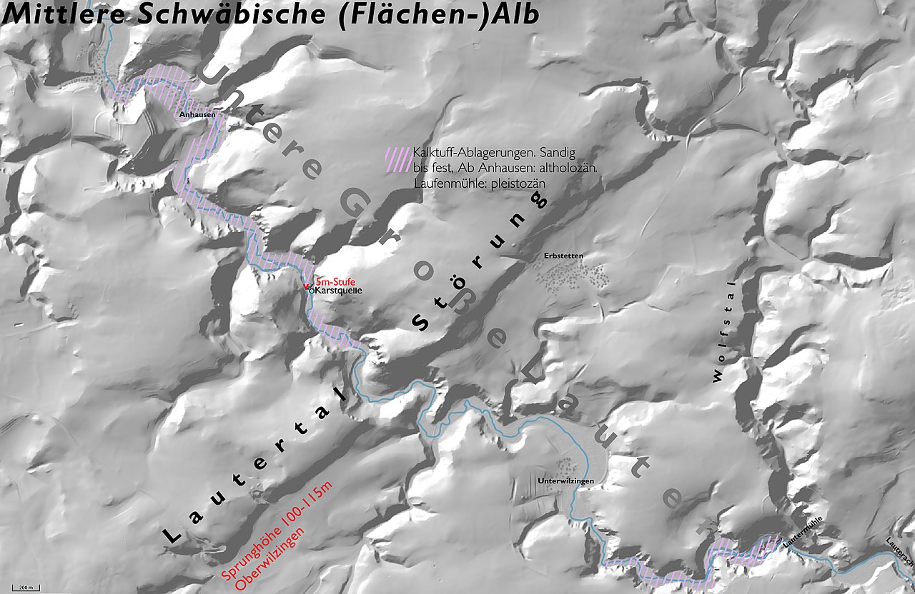
Deutsch: Digitales Höhenmodell mit Geländerelief für das Gebiet der Mittleren Flächenalb (untere Große Lauter mit Umfeld).
Die Lautertal-Störung, SSW-NNE ist in der Graphik, aber auch im Gelände morphologisch deutlich erkennbar. Die südliche Scholle liegt tiefer. Nach H. Prinz, 1959, kann diese Verwerfung in drei Zeitphasen, in Alt-Tertiär (Paläogen), Unteres Miozän und mindestens Mittleres Miozän, aufgeteilt werden. In der dritten Zeitphase, deren Verwerfungsteil südlich der Großen Lauter bei Oberwilzingen liegt, hatte die Verwerfung die beachtliche Sprunghöhe von 100-115m. Nach Prinz hatte die Störung keinen Einfluss auf das Gefälle des Flusstales.
English: digital elevation model of the terrain of the southern part of the Middle Swabian Alb. The map shows the lower Grosse Lauter) in its environment. Most prominent is the normal fault, called “Lauter-Störung”, where the hanging wall is to the south. The part of the fault southwest to the river valley has a throw of approx. 100-115 m. |
| Date | |
| Source | Own work |
| Author | Ustill |
Licensing
[edit]
- You are free:
- to share – to copy, distribute and transmit the work
- to remix – to adapt the work
- Under the following conditions:
- attribution – You must give appropriate credit, provide a link to the license, and indicate if changes were made. You may do so in any reasonable manner, but not in any way that suggests the licensor endorses you or your use.
- share alike – If you remix, transform, or build upon the material, you must distribute your contributions under the same or compatible license as the original.

File history
Click on a date/time to view the file as it appeared at that time.
| Date/Time | Thumbnail | Dimensions | User | Comment | |
|---|---|---|---|---|---|
| current | 15:26, 29 July 2018 | | 2,338 × 1,520 (1.19 MB) | Ustill (talk | contribs) |
You cannot overwrite this file.
File usage on Commons
There are no pages that use this file.
File usage on other wikis
The following other wikis use this file:
- Usage on de.wikipedia.org