File:Generalplan Ost-fr.svg
Jump to navigation
Jump to search

Size of this PNG preview of this SVG file: 425 × 599 pixels. Other resolutions: 170 × 240 pixels | 340 × 480 pixels | 544 × 768 pixels | 726 × 1,024 pixels | 1,452 × 2,048 pixels | 746 × 1,052 pixels.
Original file (SVG file, nominally 746 × 1,052 pixels, file size: 227 KB)
Captions
Captions
Add a one-line explanation of what this file represents
Summary
[edit]| Description |
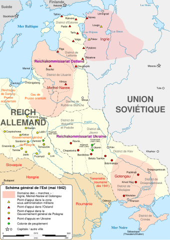
[] English: Map of the "Master Plan for the East" (Generalplan Ost) in May 1942. Español: Mapa del «Plan General del Este» (Generalplan Ost) en mayo 1942. Français : Carte du «schéma directeur pour l'Est» (Generalplan Ost) en mai 1942. |
| Date | |
| Source |
English: * Generalplan Ost.svg by Sir Henry, public domain
Français : * Generalplan Ost.svg de Sir Henry, domaine public
|
| Author | |
| Attribution (required by the license) | © Sémhur / Wikimedia Commons / |
| Other versions |
[]
|
| SVG development |


| Object location | | View this and other nearby images on: OpenStreetMap |
|---|
Licensing
[edit]
I, the copyright holder of this work, hereby publish it under the following licenses:
| Copyleft: This work of art is free; you can redistribute it and/or modify it according to terms of the Free Art License. You will find a specimen of this license on the Copyleft Attitude site as well as on other sites. |
This file is licensed under the Creative Commons Attribution-Share Alike 4.0 International, 3.0 Unported, 2.5 Generic, 2.0 Generic and 1.0 Generic license.
- You are free:
- to share – to copy, distribute and transmit the work
- to remix – to adapt the work
- Under the following conditions:
- attribution – You must give appropriate credit, provide a link to the license, and indicate if changes were made. You may do so in any reasonable manner, but not in any way that suggests the licensor endorses you or your use.
- share alike – If you remix, transform, or build upon the material, you must distribute your contributions under the same or compatible license as the original.
You may select the license of your choice.
File history
Click on a date/time to view the file as it appeared at that time.
| Date/Time | Thumbnail | Dimensions | User | Comment | |
|---|---|---|---|---|---|
| current | 16:50, 13 August 2015 | | 746 × 1,052 (227 KB) | Sémhur (talk | contribs) | Reverted to version as of 20:52, 13 March 2015 : ugly bitmap! |
| 16:10, 13 August 2015 |  | 933 × 1,315 (375 KB) | Spiridon Ion Cepleanu (talk | contribs) | 2 little details according with Westermann Grosser Atlas zur Weltgeschichte, 1985, ISBN 3-14-100919-8 | |
| 20:52, 13 March 2015 |  | 746 × 1,052 (227 KB) | Sémhur (talk | contribs) | == {{int:filedesc}} == {{Information |Description= {{en|1= Map of en:Generalplan Ost in may 1942.}} {{fr|1= Carte du fr:Generalplan Ost en mai 1942.}} |Source= {{en|1= * {{f|Generalplan Ost.svg}} by {{u|Sir Henry}}, public domain ** Itself... |
You cannot overwrite this file.
File usage on Commons
The following 6 pages use this file:
File usage on other wikis
The following other wikis use this file: