File:General view of St. Mary's Church in Katzwang.jpg
Jump to navigation
Jump to search

Size of this preview: 416 × 599 pixels. Other resolutions: 167 × 240 pixels | 333 × 480 pixels | 533 × 768 pixels | 711 × 1,024 pixels | 1,989 × 2,863 pixels.
Original file (1,989 × 2,863 pixels, file size: 4.49 MB, MIME type: image/jpeg)
Captions
Captions
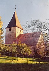
General view of St. Mary's Church in Katzwang..
Summary
[edit]
| Description |
English: The Church is among the top ten architectural and historical attractions of Nuremberg. It is believed that this Church was founded by Wilibald in the 8th century. The modern building was first mentioned in 1287.
The Church is located on the banks of the river Regnitz in the place where there was previously a Ford across the river. The Church was surrounded by a wall, which made it the so-called verkirch-Church and fortress at the same time, protecting the approaches to the strategically important Ford, which lay on the ancient trade route. This route passed through the neighboring settlement of Orenburg and was called the "Venetian road". In addition, the Church could pray for a safe passage through the Ford during the spring flood.Gesamtansicht der Marienkirche in Katzwang.
Ab: .
Die Kirche gehört zu den Top ten der architektonischen und historischen Sehenswürdigkeiten Nürnbergs. Es wird angenommen, dass diese Kirche von Willibald im 8.Jahrhundert gegründet wurde. Das moderne Gebäude wurde erstmals 1287 erwähnt. Die Kirche befindet sich am Ufer der Regnitz an der Stelle, an der früher eine Furt über den Fluss Stand. Die Kirche war von einer Mauer umgeben, die Sie zur sogenannten verkirch-Kirche und Festung machte und gleichzeitig die Annäherungen an die strategisch wichtige Furt, die auf dem alten Handelsweg lag, schützte. Diese route führte durch die benachbarte Siedlung Orenburg und wurde "venezianische Straße"genannt. Darüber hinaus konnte die Kirche während der frühjahrsflut für einen sicheren Durchgang durch die Furt beten.Acèh: .
Церковь входит в первую десятку архитектурно - исторических достопримечательностей Нюрнберга. Существует мнение, что эта церковь основана Вилибальдом еще в 8 веке. Современное здание впервые упоминается в 1287 г. Церковь находится на берегу реки Реднитц в месте, где ранее находился брод через реку. Церковь была окружена стеною, что делало ее так называемой веркирхой - церковью и одновременно крепостью, защищавшей подступы к стратегически важному броду, лежавшему на старинном торговом пути. Этот путь проходил через соседнее поселение Корнбург и назывался «Венецианской дорогой». К тому же в церкви можно было помолится о благополучном переходе через брод во время весеннего половодья. |
| Date | |
| Source | Own work |
| Author | Vitold Muratov |
Licensing
[edit]
I, the copyright holder of this work, hereby publish it under the following license:
This file is licensed under the Creative Commons Attribution-Share Alike 4.0 International license.
- You are free:
- to share – to copy, distribute and transmit the work
- to remix – to adapt the work
- Under the following conditions:
- attribution – You must give appropriate credit, provide a link to the license, and indicate if changes were made. You may do so in any reasonable manner, but not in any way that suggests the licensor endorses you or your use.
- share alike – If you remix, transform, or build upon the material, you must distribute your contributions under the same or compatible license as the original.
File history
Click on a date/time to view the file as it appeared at that time.
| Date/Time | Thumbnail | Dimensions | User | Comment | |
|---|---|---|---|---|---|
| current | 17:38, 28 October 2019 | | 1,989 × 2,863 (4.49 MB) | Vitold Muratov (talk | contribs) | User created page with UploadWizard |
You cannot overwrite this file.
File usage on Commons
There are no pages that use this file.
File usage on other wikis
The following other wikis use this file:
- Usage on pl.wikipedia.org