File:General Map of the City of Lisbon, 1785 WDL926.png
Jump to navigation
Jump to search

Size of this preview: 768 × 600 pixels. Other resolutions: 307 × 240 pixels | 615 × 480 pixels | 983 × 768 pixels | 1,280 × 1,000 pixels | 1,311 × 1,024 pixels.
Original file (1,311 × 1,024 pixels, file size: 2.87 MB, MIME type: image/png)
Captions
Captions
Add a one-line explanation of what this file represents
Summary
[edit]
| Author |
Русский: Милиент, Франк Д.
Français : Milient, Franc D.
English: Milient, Franc D.
中文:米里恩特, 弗兰克 D.
Português: Milient, Franc D.
العربية: ميلينت, فرانك د.
Español: Milient, Franc D. |
| Title |
Русский: Общая карта города Лиссабон, 1785 г.
Français : Carte générale de la ville de Lisbonne, 1785
English: General Map of the City of Lisbon, 1785
中文:里斯本市地形图,1785 年
Português: Mapa Geral da Cidade de Lisboa, 1785
العربية: خريطة عامة لمدينة لشبونة، 1785
Español: Mapa general de la ciudad de Lisboa, 1785 |
| Description |
Русский: Данная подробная карта столицы Португалии — Лиссабон — является работой картографа Франка Д. Милиента. В 1755 году Лиссабон был практически полностью разрушен во время землетрясения, которое вызвало приливную волну. Главный министр того времени Себастьян Жозе де Карвалью е Мело (1699-1782 гг.), известный также как первый маркиз Помбал, решил уничтожить то, что осталось от центра города и перестроить город в соответствии с современными представлениями о городском планировании. Проект реконструкции отражен на этой карте, показывающей продуманный план центральной части города. Карвалью е Мело также проводил испытания архитектурных моделей на способность выдерживать землетрясения и цунами. Его стратегия привела к тому, что восстановленные здания в центре Лиссабона могут по праву считаться первыми в мире сейсмостойкими зданиями.
Français : Cette carte détaillée de la capitale portugaise, Lisbonne, est l'oeuvre du cartographe Franc D. Milient. En 1755, Lisbonne fut presque complètement détruite par un tremblement de terre suivi d'un raz-de-marée. Un ministre de l'époque, Sebastião José de Carvalho e Melo (1699-1782), également connu sous le titre de premier marquis de Pombal, a décidé de raser ce qui restait du centre ville et de reconstruire selon les notions contemporaines d'urbanisation. On peut apprécier la reconstruction sur cette carte, qui montre l'aménagement ordonné de la ville basse à partir d'une schéma géométrique. Carvalho e Melo a également testé des modèles architecturaux en fonction de leur capacité à résister aux tremblements de terre et aux tsunamis. En raison de sa politique, les immeubles reconstruits dans le centre de Lisbonne peuvent être considérés comme les premiers bâtiments parasismiques.
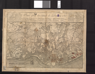
English: This detailed map of the Portuguese capital, Lisbon, is the work of cartographer Franc D. Milient. In 1755, Lisbon was almost completely destroyed by an earthquake followed by a tidal wave. The chief minister at that time, Sebastião José de Carvalho e Melo (1699-1782), also known as the first Marquis of Pombal, decided to raze what remained of the city center and rebuild it according to contemporary ideas about urban planning. The reconstruction can be seen in this map, which shows the orderly layout of the downtown along a grid. Carvalho e Melo also tested architectural models for their ability to withstand earthquakes and tsunamis. As a result of his policies, the reconstructed buildings in the center of Lisbon can be thought of as the world’s first earthquake-proof buildings.
中文:这幅葡萄牙首都里斯本的详细地图出自制图师弗兰克 D. 米利恩特。 1755 年,里斯本几乎被一场地震及其后的海啸完全毁灭。 当时的首相塞巴斯蒂昂·何塞·德·卡瓦略·梅洛(1699-1782 年),亦称为第一彭巴尔侯爵,决定重整灾后的城市中心,按照城市规划的现代理念进行重建。 这幅地图描绘了重建的效果及沿方格网排列顺畅的市中心布局。 卡瓦略·梅洛还测试了建筑模型,以检测其抗震与抵抗海啸的能力。 在他的政策下,里斯本中心重建的建筑可称为世界上第一批抗震建筑。
Português: Este mapa detalhado da capital portuguesa, Lisboa, é o trabalho do cartógrafo Franc D. Milient. Em 1755, Lisboa foi quase completamente destruída por um terremoto seguido de um maremoto. O ministro-chefe da época, Sebastião José de Carvalho e Melo (1699-1782), também conhecido como o primeiro Marquês de Pombal, decidiu demolir o que restara do centro da cidade e reconstruí-lo de acordo com ideias contemporâneas sobre planejamento urbano. A reconstrução pode ser vista neste mapa, que mostra a disposição sistemática do centro da cidade ao longo de uma planilha. Carvalho e Melo testou, também, modelos arquitetônicos quanto à sua capacidade de resistir a terremotos e maremotos. Como resultado de suas políticas, os prédios reconstruídos no centro de Lisboa podem ser considerados os primeiros prédios à prova de abalos sísmicos do mundo.
العربية: أعد هذه الخريطة المفصلة للعاصمة البرتغالية لشبونة رسام الخرائط فرانك د. مايلينت وكانت لشبونة قد دمرت تماما تقريبا في عام 1755 بسبب زلزال أعقبته موجة مد. وقد قرر رئيس الوزراء في ذلك الوقت سباستياو خوسيه دي كارفاليو إي ميلو (1699-1782)، المعروف أيضا بأول ماركيز لبومبال، بهدم ما تبقى من وسط المدينة وإعادة بنائه وفقا للأفكار المعاصرة عن التخطيط الحضري. ويمكن رؤية إعادة الإعمار في هذه الخريطة، حيث تظهر التصميم المنظم لوسط المدينة على امتداد الشبكة. اختبر كارفاليو إي ميلو ايضا نماذج هندسية لمعرفة مدى قدرتها على الصمود أمام الزلازل وموجات المد. ونتيجة لسياساته، يمكن اعتبار المباني التي أُعيد بناؤها في وسط لشبونة بأول مبان في العالم مقاومة للزلازل.
Español: Este mapa detallado de la capital portuguesa, Lisboa, es obra del cartógrafo Franc D. Milient. En 1755, Lisboa fue casi completamente destruida por un terremoto seguido de un maremoto. El primer ministro en ese momento, Sebastião José de Carvalho e Melo (1699-1782), también conocido como el primer Marqués de Pombal, decidió arrasar lo que quedaba del centro de la ciudad y reconstruirla de acuerdo a las ideas contemporáneas sobre planificación urbana. La reconstrucción se puede apreciar en este mapa, que muestra la disposición ordenada de la ciudad a lo largo de una cuadrícula. Carvalho e Melo también probó modelos arquitectónicos por su capacidad para resistir los terremotos y tsunamis. Como resultado de sus políticas, la reconstrucción de edificios en el centro de Lisboa se puede considerar como los primeros edificios a prueba de terremotos. |
| Date | 1785 |
| Medium |
Русский: Карты
Français : Cartes
English: Maps
中文:地图
Português: Mapas
العربية: خرائط
Español: Mapas |
| Dimensions |
English: 1 map : 30 x 41 centimeters |
| Collection |
Русский: Национальная библиотека Бразилии
Français : Bibliothèque nationale du Brésil
English: National Library of Brazil
中文:巴西国家图书馆
Português: Biblioteca Nacional do Brasil
العربية: مكتبة البرازيل الوطنية
Español: Biblioteca Nacional de Brasil |
| Place of creation |
Русский: Португалия
Français : Portugal
English: Portugal
中文:葡萄牙
Português: Portugal
العربية: البرتغال
Español: Portugal |
| Notes | Original language title: Plano geral da cidade de Lisboa em 1785 |
| References | http://hdl.loc.gov/loc.wdl/brrjbn.926 |
| Source/Photographer |
|
Licensing
[edit]
|
This is a faithful photographic reproduction of a two-dimensional, public domain work of art. The work of art itself is in the public domain for the following reason:
The official position taken by the Wikimedia Foundation is that "faithful reproductions of two-dimensional public domain works of art are public domain".
This photographic reproduction is therefore also considered to be in the public domain in the United States. In other jurisdictions, re-use of this content may be restricted; see Reuse of PD-Art photographs for details. | ||||
File history
Click on a date/time to view the file as it appeared at that time.
| Date/Time | Thumbnail | Dimensions | User | Comment | |
|---|---|---|---|---|---|
| current | 02:01, 12 March 2014 | | 1,311 × 1,024 (2.87 MB) | Fæ (talk | contribs) | =={{int:filedesc}}== {{Artwork |artist = |author ={{ru|1=Милиент, Франк Д.}} {{fr|1=Milient, Franc D.}} {{en|1=Milient, Franc D.}} {{zh|1=米里恩特, 弗兰克 D.}} {{pt|1=Milient, Franc D.}} {{ar|1=ميلينت, فرانك د.}} {{es|1=... |
You cannot overwrite this file.
File usage on Commons
The following page uses this file: