File:Generalʹnai︠a︡ Karta Smolenskoĭ Gubernii Sʺ pokazaniemʺ pochtovykhʺ i bolʹshikhʺ proi︠e︡zzhikhʺ dorogʺ, stant︠s︡iĭ i razstoi︠a︡nii︠a︡ mezhdu onymi verstʺ. LOC 2018688655.jpg
Jump to navigation
Jump to search

Size of this preview: 711 × 599 pixels. Other resolutions: 285 × 240 pixels | 570 × 480 pixels | 911 × 768 pixels | 1,215 × 1,024 pixels | 2,430 × 2,048 pixels | 5,744 × 4,841 pixels.
Original file (5,744 × 4,841 pixels, file size: 3.2 MB, MIME type: image/jpeg)
Captions
Captions
Add a one-line explanation of what this file represents
Summary
[edit]| Description |
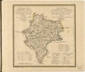
English: This 1821 map of Smolensk Provinceis from a larger work,Geograficheskii atlas Rossiiskoi imperii, tsarstva Pol'skogo i velikogo kniazhestva Finliandskogo(Geographical atlas of the Russian Empire, the Kingdom of Poland, and the Grand Duchy of Finland), containing 60 maps of the Russian Empire. Compiled and engraved by Colonel V.P. Piadyshev, it reflects the detailed mapping carried out by Russian military cartographers in the first quarter of the 19th century. The map shows population centers (six gradations by size), postal stations, roads (four types), state, provincial and district borders,factories, and monasteries. Distances are shown in versts, a Russian measure, now no longer used, equal to 1.07 kilometers.Legends and place-names are in Russian and French. The territory depicted on the map lies near the western border of present-day Russia. Smolensk was founded in the ninth century, soon after Novgorod. Smolensk benefited from being located between the Western Dvina and Dnieper Rivers, and thus was a crucial stop for the Vikings, who used these river systems to trade between the Baltic and Black Seas. Smolensk was in the center of the trade route between the Varangians and the Greeks, which connected Constantinople, Kievan Rus', and Scandinavia, and its economy profited as a result. It eventually became a powerful city in Kievan Rus' that rivalled Kiev itself. Smolensk later fell under the Grand Duchy of Lithuania but was captured by Muscovy in 1514. Grand Prince Vasily III built the famous Novodevichy Convent in Moscow to commemorate this event, replete with a central church and icon named in honor of the capture of Smolensk. After a major battle in 1812, Napoleon entered Smolensk during his Russian campaign, an event noted in Leo Tolstoy's great novel, War and Peace. World Digital Library. |
||
| Title | Generalʹnai︠a︡ Karta Smolenskoĭ Gubernii Sʺ pokazaniemʺ pochtovykhʺ i bolʹshikhʺ proi︠e︡zzhikhʺ dorogʺ, stant︠s︡iĭ i razstoi︠a︡nii︠a︡ mezhdu onymi verstʺ. | ||
| Shelf ID | http://lccn.loc.gov/2018688655 | ||
| Date | |||
| Source | https://www.loc.gov/item/2018688655/ | ||
| Author | Pi︠A︡Dyshev, Vasiliĭ Petrovich; Faleleef; Russia. General Staff. Military Topographical Depot | ||
| Permission (Reusing this file) |
|
||
| Other versions |
|
||
| Location | Russian Federation · Smolensk Oblast | ||
| Part of | Geographical Atlas Of The Russian Empire, The Kingdom Of Poland, And The Grand Duchy Of Finland · Catalog · National Library Of Russia · Meeting Of Frontiers | ||
| Subject | Russian Federation · Maps · Atlases · Smolensk Oblast · Siberia |

Licensing
[edit]
|
This is a faithful photographic reproduction of a two-dimensional, public domain work of art. The work of art itself is in the public domain for the following reason:
The official position taken by the Wikimedia Foundation is that "faithful reproductions of two-dimensional public domain works of art are public domain".
This photographic reproduction is therefore also considered to be in the public domain in the United States. In other jurisdictions, re-use of this content may be restricted; see Reuse of PD-Art photographs for details. | ||||
File history
Click on a date/time to view the file as it appeared at that time.
| Date/Time | Thumbnail | Dimensions | User | Comment | |
|---|---|---|---|---|---|
| current | 00:40, 28 January 2020 | | 5,744 × 4,841 (3.2 MB) | Fæ (talk | contribs) | LOC Maps https://www.loc.gov/item/2018688655/ #21249 |
You cannot overwrite this file.
File usage on Commons
The following page uses this file: