File:Generalʹnai︠a︡ Karta Kostromskoĭ Gubernii Sʺ pokazaniemʺ pochtovykhʺ i bolʹshikhʺ proi︠e︡zzhikhʺ dorogʺ, stant︠s︡iĭ i razstoi︠a︡nii︠a︡ mezhdu onymi verstʺ. LOC 2018688666.jpg
Jump to navigation
Jump to search

Size of this preview: 711 × 600 pixels. Other resolutions: 285 × 240 pixels | 569 × 480 pixels | 910 × 768 pixels | 1,214 × 1,024 pixels | 2,428 × 2,048 pixels | 5,756 × 4,856 pixels.
Original file (5,756 × 4,856 pixels, file size: 3.67 MB, MIME type: image/jpeg)
Captions
Captions
Add a one-line explanation of what this file represents
Summary
[edit]| Description |
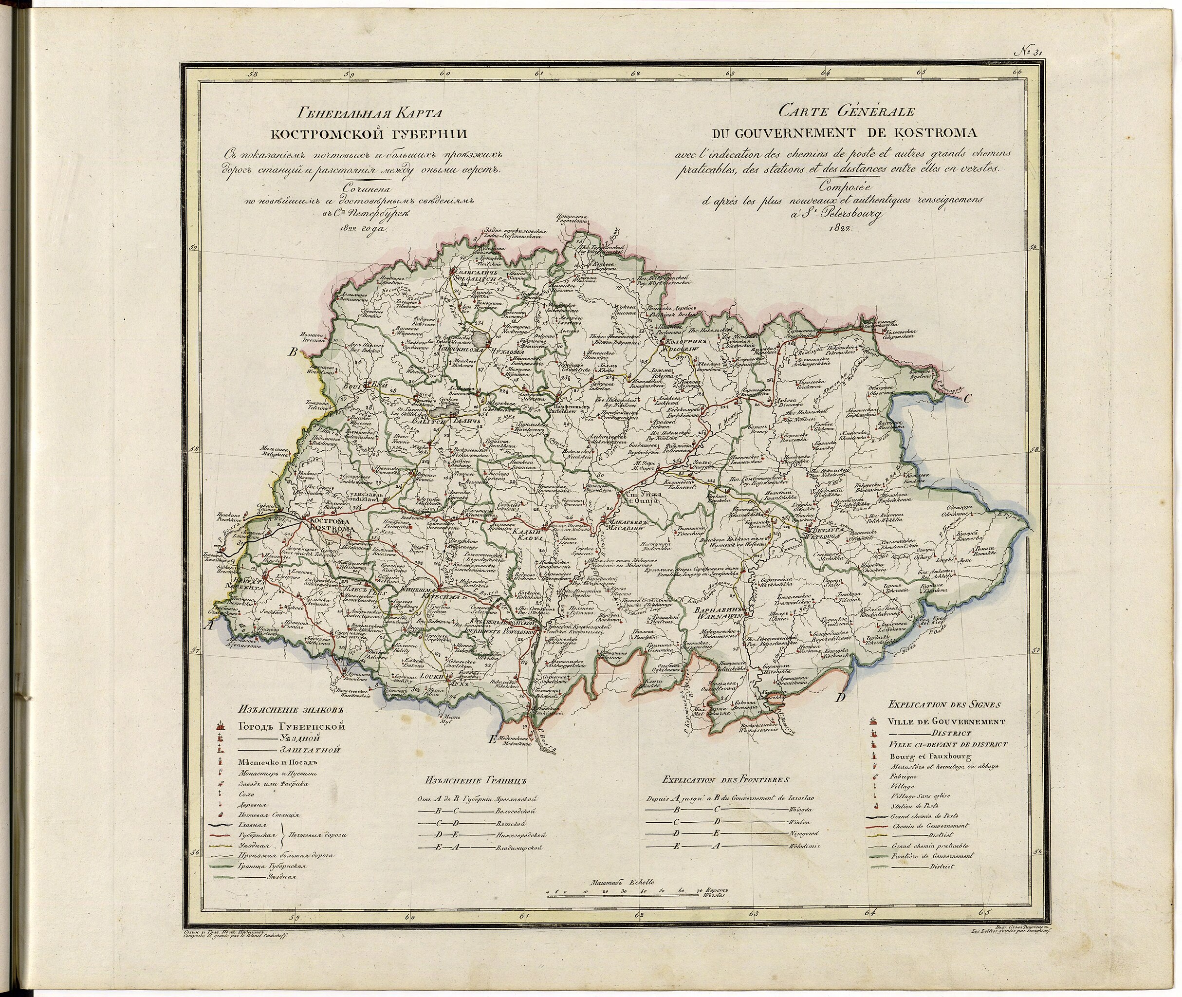
English: This 1822 map of Kostroma Provinceis from a larger work,Geograficheskii atlas Rossiiskoi imperii, tsarstva Pol'skogo i velikogo kniazhestva Finliandskogo(Geographical atlas of the Russian Empire, the Kingdom of Poland, and the Grand Duchy of Finland), containing 60 maps of the Russian Empire. Compiled and engraved by Colonel V.P. Piadyshev, it reflects the detailed mapping carried out by Russian military cartographers in the first quarter of the 19th century. The map shows population centers (six gradations by size), postal stations, roads (four types), provincial and district borders,monasteries, and factories. Distances are shown in versts, a Russian measure, now no longer used, equal to 1.07 kilometers.Legends and place-names are in Russian and French. Kostroma was founded in the 12th century, on a prime location along the Volga River. After withstanding Mongol raids, Kostroma became a refuge in the northern forests for Russian princes seeking to escape the Golden Horde. The city benefited from its location on the main trade route between Moscow and Arkhangelsk on the White Sea (and from there by ship to Western Europe), and grew in wealth and importance over the centuries. Kostroma later became famous for its Ipatiev Monastery, founded around 1330 by a princely Tatar ancestor of Tsar Boris Godunov, who rebuilt it in stone in the early 17th century. The Romanov family also came from the Kostroma region. It was from the Ipatiev Monastery that Mikhail Romanov was summoned to be the tsar of Muscovy in 1613, following a Polish invasion and the Time of Troubles. The town was famously redesigned in a radial pattern by Catherine the Great and her urban planners in the late 18th century. Tsar Nicholas II visited Kostroma in 1913 to commemorate the origins of the Romanov family dynasty amidst the tercentenary celebrations of the Romanov tsars. World Digital Library. |
||
| Title | Generalʹnai︠a︡ Karta Kostromskoĭ Gubernii Sʺ pokazaniemʺ pochtovykhʺ i bolʹshikhʺ proi︠e︡zzhikhʺ dorogʺ, stant︠s︡iĭ i razstoi︠a︡nii︠a︡ mezhdu onymi verstʺ. | ||
| Shelf ID | http://lccn.loc.gov/2018688666 | ||
| Date | |||
| Source | https://www.loc.gov/item/2018688666/ | ||
| Author | Pi︠A︡Dyshev, Vasiliĭ Petrovich; Russia. General Staff. Military Topographical Depot; Finaghenof | ||
| Permission (Reusing this file) |
|
||
| Other versions |
|
||
| Location | Russian Federation · Kostroma Oblast | ||
| Part of | Geographical Atlas Of The Russian Empire, The Kingdom Of Poland, And The Grand Duchy Of Finland · Catalog · National Library Of Russia · Meeting Of Frontiers | ||
| Subject | Russian Federation · Maps · Atlases · Kostroma Oblast · Siberia |


Licensing
[edit]
|
This is a faithful photographic reproduction of a two-dimensional, public domain work of art. The work of art itself is in the public domain for the following reason:
The official position taken by the Wikimedia Foundation is that "faithful reproductions of two-dimensional public domain works of art are public domain".
This photographic reproduction is therefore also considered to be in the public domain in the United States. In other jurisdictions, re-use of this content may be restricted; see Reuse of PD-Art photographs for details. | ||||
File history
Click on a date/time to view the file as it appeared at that time.
| Date/Time | Thumbnail | Dimensions | User | Comment | |
|---|---|---|---|---|---|
| current | 04:45, 28 January 2020 | | 5,756 × 4,856 (3.67 MB) | Fæ (talk | contribs) | LOC Maps https://www.loc.gov/item/2018688666/ #22743 |
You cannot overwrite this file.
File usage on Commons
The following 4 pages use this file:
- User:Aconcagua/Alaska new/2020 March
- File:Generalʹnai︠a︡ Karta Kostromskoĭ Gubernii Sʺ pokazaniemʺ pochtovykhʺ i bolʹshikhʺ proi︠e︡zzhikhʺ dorogʺ, stant︠s︡iĭ i razstoi︠a︡nii︠a︡ mezhdu onymi verstʺ. LOC 2018688666.tif
- File:Geograficheskoĭ atlasʺ Rossiĭskoĭ Imperii, T︠S︡arstva Polʹskago i Velikago kni︠a︡zhestva Finli︠a︡ndskago. LOC 2018688635-33.jpg (file redirect)
- File:Geograficheskoĭ atlasʺ Rossiĭskoĭ Imperii, T︠S︡arstva Polʹskago i Velikago kni︠a︡zhestva Finli︠a︡ndskago. LOC 2018688635-33.tif