File:Generalʹnai︠a︡ Karta Kavkazskoĭ Oblasti i zemelʹ gorskikhʺ narodovʺ Sʺ pokazaniemʺ pochtovykhʺ i bolʹshikhʺ proi︠e︡zzhikhʺ dorogʺ, stant︠s︡iĭ i razstoi︠a︡nii︠a︡ mezhdu onymi verstʺ. LOC 2018688679.jpg
Jump to navigation
Jump to search

Size of this preview: 708 × 599 pixels. Other resolutions: 284 × 240 pixels | 567 × 480 pixels | 907 × 768 pixels | 1,210 × 1,024 pixels | 2,420 × 2,048 pixels | 5,756 × 4,872 pixels.
Original file (5,756 × 4,872 pixels, file size: 4.14 MB, MIME type: image/jpeg)
Captions
Captions
Add a one-line explanation of what this file represents
Summary
[edit]| Description |
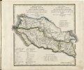
English: This 1825 map of the Caucasus and Land of the Mountain Peoplesis from a larger work,Geograficheskii atlas Rossiiskoi imperii, tsarstva Pol'skogo i velikogo kniazhestva Finliandskogo(Geographical atlas of the Russian Empire, the Kingdom of Poland, and the Grand Duchy of Finland), containing 60 maps of the Russian Empire. Compiled and engraved by Colonel V.P. Piadyshev, it reflects the detailed mapping carried out by Russian military cartographers in the first quarter of the 19th century. The map shows population centers (six gradations by size), postal stations, roads (four types), provincial and district borders,borders with the land of mountain people, borders with the Black Sea Cossack Host, monasteries, factories, forts, and redoubts. Distances are shown in versts, a Russian measure, now no longer used, equal to 1.07 kilometers.Legends and place-names are in Russian and French. The North Caucasus has traditionally been demarcated as the region north of the Caucasus Mountains, between the Sea of Azov and the Caspian Sea. For centuries this area was at the crossroads of several cultures, resulting in a long history of trade and conflict amongst the rulers of Persia, Russia, Central Asia, and Ottoman Turkey. The Russian Empire conquered the region in the late 18th and early 19th centuries. These military conquests were immortalized in the literature of the writer Mikhail Lermontov and in the early writings of Count Leo Tolstoy. Upon victory over Ottoman Turkey in the late 18th century, Catherine the Great ordered the governor-general of Russia's new southern provinces, Grigorii Potemkin, to construct fortresses across the southern regions, one of which was to be in Stavropol. World Digital Library. |
||
| Title | Generalʹnai︠a︡ Karta Kavkazskoĭ Oblasti i zemelʹ gorskikhʺ narodovʺ Sʺ pokazaniemʺ pochtovykhʺ i bolʹshikhʺ proi︠e︡zzhikhʺ dorogʺ, stant︠s︡iĭ i razstoi︠a︡nii︠a︡ mezhdu onymi verstʺ. | ||
| Shelf ID | http://lccn.loc.gov/2018688679 | ||
| Date | |||
| Source | https://www.loc.gov/item/2018688679/ | ||
| Author | Pi︠A︡Dyshev, Vasiliĭ Petrovich; Ieremin; Russia. General Staff. Military Topographical Depot | ||
| Permission (Reusing this file) |
|
||
| Other versions |
|
||
| Location | Russian Federation · Krasnodar Krai | ||
| Part of | Geographical Atlas Of The Russian Empire, The Kingdom Of Poland, And The Grand Duchy Of Finland · Catalog · National Library Of Russia · Meeting Of Frontiers | ||
| Subject | Russian Federation · Maps · Atlases · Siberia · Krasnodar Krai |

Licensing
[edit]
|
This is a faithful photographic reproduction of a two-dimensional, public domain work of art. The work of art itself is in the public domain for the following reason:
The official position taken by the Wikimedia Foundation is that "faithful reproductions of two-dimensional public domain works of art are public domain".
This photographic reproduction is therefore also considered to be in the public domain in the United States. In other jurisdictions, re-use of this content may be restricted; see Reuse of PD-Art photographs for details. | ||||
File history
Click on a date/time to view the file as it appeared at that time.
| Date/Time | Thumbnail | Dimensions | User | Comment | |
|---|---|---|---|---|---|
| current | 12:26, 21 January 2020 | | 5,756 × 4,872 (4.14 MB) | Fæ (talk | contribs) | LOC Maps https://www.loc.gov/item/2018688679/ #24845 |
You cannot overwrite this file.
File usage on Commons
The following page uses this file: