File:Gemarkungskarte Deisendorf.jpg
Jump to navigation
Jump to search

Size of this preview: 458 × 599 pixels. Other resolutions: 183 × 240 pixels | 367 × 480 pixels | 810 × 1,060 pixels.
Original file (810 × 1,060 pixels, file size: 121 KB, MIME type: image/jpeg)
Captions
Captions
Add a one-line explanation of what this file represents
Summary
[edit]
| Description |
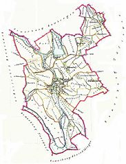
Deutsch: Historische Gemarkungskarte der Gemeinde Deisendorf (selbst aus altem Gemarkungsatlas gescannt)
Leider keine Angabe, wie alt der Atlas war, vermutlich 19. Jh oder frühes 20. Jh. --Crux 00:57, 29. Dez 2005 (CET) |
| Date | 6 September 2005 (original upload date) |
| Source | Transferred from de.wikipedia to Commons by Ireas using CommonsHelper. |
| Author | The original uploader was Raktop at German Wikipedia. |
Licensing
[edit]
|
This work is in the public domain in its country of origin and other countries and areas where the copyright term is the author's life plus 70 years or fewer. | |
| This file has been identified as being free of known restrictions under copyright law, including all related and neighboring rights. | |
Original upload log
[edit]
The original description page was here. All following user names refer to de.wikipedia.
- 2005-09-06 23:01 Raktop 810×1060× (123809 bytes) Historische Gemarkungskarte der Gemeinde Deisendorf (selbst aus altem Gemarkungsatlas gescannt)
File history
Click on a date/time to view the file as it appeared at that time.
| Date/Time | Thumbnail | Dimensions | User | Comment | |
|---|---|---|---|---|---|
| current | 03:11, 7 October 2010 | | 810 × 1,060 (121 KB) | File Upload Bot (Magnus Manske) (talk | contribs) | {{BotMoveToCommons|de.wikipedia|year={{subst:CURRENTYEAR}}|month={{subst:CURRENTMONTHNAME}}|day={{subst:CURRENTDAY}}}} {{Information |Description={{de|Historische Gemarkungskarte der Gemeinde Deisendorf (selbst aus altem Gemarkungsatlas gescannt) Leide |
You cannot overwrite this file.
File usage on Commons
There are no pages that use this file.
File usage on other wikis
The following other wikis use this file:
- Usage on de.wikipedia.org