File:Gelmerbahn near the edge.JPG
Jump to navigation
Jump to search

Size of this preview: 450 × 600 pixels. Other resolutions: 180 × 240 pixels | 360 × 480 pixels | 576 × 768 pixels | 768 × 1,024 pixels | 1,944 × 2,592 pixels.
Original file (1,944 × 2,592 pixels, file size: 3.61 MB, MIME type: image/jpeg)
Captions
Captions
Add a one-line explanation of what this file represents
Summary
[edit]
| Description |
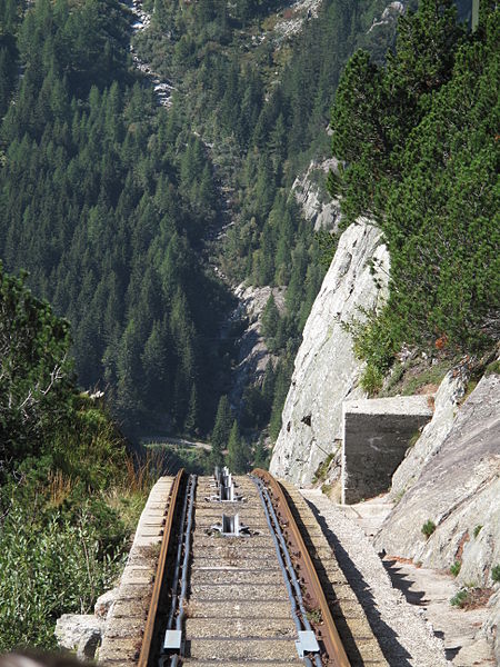
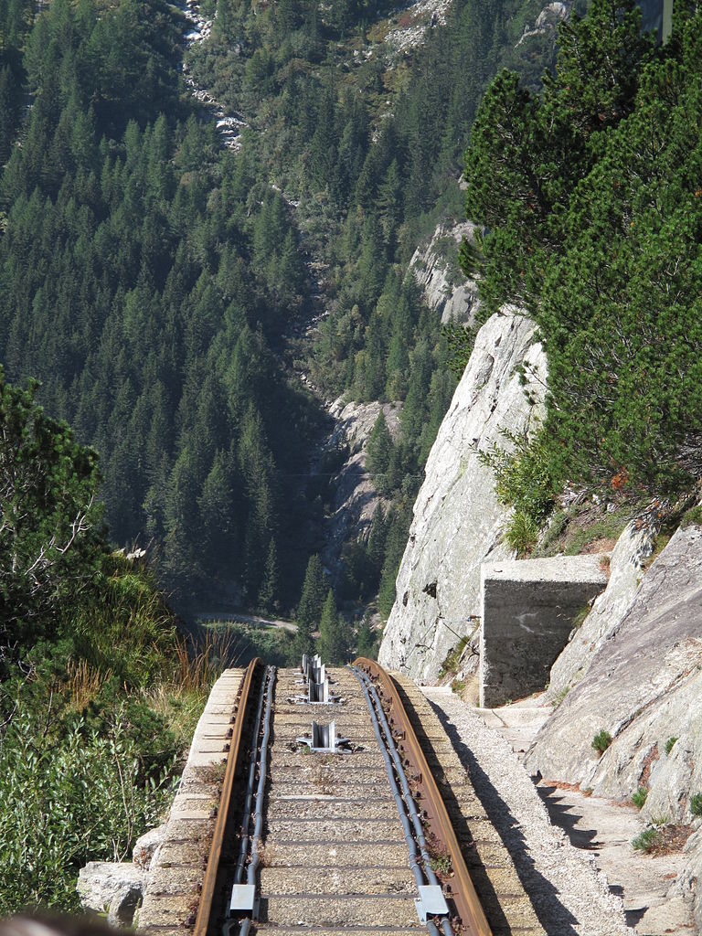
English: Starting near the shore of the Gelmersee (1850m) the track of the Gelmerbahn plunges into the valley. The steepest part has an inclination of 106%.
Deutsch: Kurz nach dem Start bei der Bergstation beim Gelmersee (1850m) tauchen die Gleise der Gelmerbahn ins Tal. Der steilste Teil der Strecke hat eine Neigung von 106%. |
| Date | |
| Source | Own work |
| Author | Maurice Chédel |
Licensing
[edit]
I, the copyright holder of this work, hereby publish it under the following licenses:

|
Permission is granted to copy, distribute and/or modify this document under the terms of the GNU Free Documentation License, Version 1.2 or any later version published by the Free Software Foundation; with no Invariant Sections, no Front-Cover Texts, and no Back-Cover Texts. A copy of the license is included in the section entitled GNU Free Documentation License. |
This file is licensed under the Creative Commons Attribution-Share Alike 3.0 Unported, 2.5 Generic, 2.0 Generic and 1.0 Generic license.
- You are free:
- to share – to copy, distribute and transmit the work
- to remix – to adapt the work
- Under the following conditions:
- attribution – You must give appropriate credit, provide a link to the license, and indicate if changes were made. You may do so in any reasonable manner, but not in any way that suggests the licensor endorses you or your use.
- share alike – If you remix, transform, or build upon the material, you must distribute your contributions under the same or compatible license as the original.
You may select the license of your choice.
File history
Click on a date/time to view the file as it appeared at that time.
| Date/Time | Thumbnail | Dimensions | User | Comment | |
|---|---|---|---|---|---|
| current | 13:07, 16 January 2013 | | 1,944 × 2,592 (3.61 MB) | Altiplano (talk | contribs) | {{Information |Description ={{en|1=Starting near the shore of the Gelmersee (1850m) the track of the Gelmerbahn plunges into the valley. The steepest part has an inclination of 106%.}} {{de|1=Kurz nach dem Start bei der Bergstation beim Gelmersee (1... |
You cannot overwrite this file.
File usage on Commons
There are no pages that use this file.