File:Gaur Kotwali Gate by Ravenshaw 1860.jpg
Jump to navigation
Jump to search

Size of this preview: 754 × 600 pixels. Other resolutions: 302 × 240 pixels | 604 × 480 pixels | 966 × 768 pixels | 1,280 × 1,018 pixels | 2,560 × 2,036 pixels | 4,000 × 3,181 pixels.
Original file (4,000 × 3,181 pixels, file size: 2.01 MB, MIME type: image/jpeg)
Captions
Captions
Add a one-line explanation of what this file represents
Summary
[edit]
| Description |
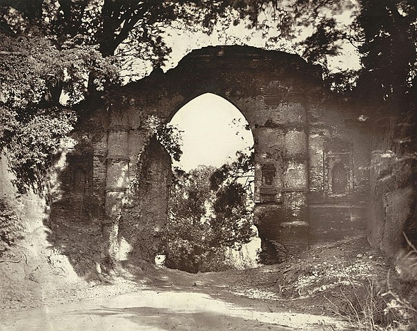
English: Photograph taken in the 1860s by John Henry Ravenshaw, one of 45 prints in the album 'Gaur: Its Ruins and Inscriptions'. Once known as Lakshmanavati or Lakhnauti, Gaur was an ancient capital of the rulers of Bengal. It came to prominence under the Buddhist Palas from the 8th century, and then prospered under the Hindu Senas from the 12th century. It fell to the Delhi Sultanate in the 13th century and later served as the capital for the independent Sultans of Bengal from the mid-14th century till the 16th century, except for an interval between 1354 to 1442 when neighbouring Pandua was made capital. Gaur was relinquished to ruin and decay by the end of the 16th century. With its history as a provincial centre of Islamic culture, Gaur has the remnants of many monuments. Part of the 15th century fort remains along with its much ruined gateways or darwazas. Ravenshaw wrote of this view looking along the road towards the arched Kotwali Darwaza which marked the southern end: 'Two miles further down the road brings us to the southern rampart of the city, through which the road passes, under a magnificent archway known as the Kotwali Gate. It is fifty-one feet under the arch, and was provided with a semicircular abutment on either side, for the military guard on duty. Even in its present ruined state, this gateway is one of the most imposing sights in Gaur; tamarind trees overhang it on all sides, while large pipal trees may be observed springing from the centre of its walls.' |
| Date | |
| Source | The British Library Board |
| Author | Thomas Edward Ravenshaw |
| Camera location | | View this and other nearby images on: OpenStreetMap |
|---|
Licensing
[edit]
|
This is a faithful photographic reproduction of a two-dimensional, public domain work of art. The work of art itself is in the public domain for the following reason:
The official position taken by the Wikimedia Foundation is that "faithful reproductions of two-dimensional public domain works of art are public domain".
This photographic reproduction is therefore also considered to be in the public domain in the United States. In other jurisdictions, re-use of this content may be restricted; see Reuse of PD-Art photographs for details. | ||||
File history
Click on a date/time to view the file as it appeared at that time.
| Date/Time | Thumbnail | Dimensions | User | Comment | |
|---|---|---|---|---|---|
| current | 13:50, 4 August 2020 | | 4,000 × 3,181 (2.01 MB) | Remitamine (talk | contribs) | Higher resolution version |
| 03:19, 18 April 2020 |  | 712 × 566 (194 KB) | NahidHossain (talk | contribs) | Uploaded a work by Thomas Edward Ravenshaw from [http://www.bl.uk/onlinegallery/onlineex/apac/photocoll/g/019pho000000978u00019000.html The British Library Board] with UploadWizard |
You cannot overwrite this file.
File usage on Commons
There are no pages that use this file.
File usage on other wikis
The following other wikis use this file:
- Usage on bn.wikipedia.org