File:Garbach (Hönne) in Balve-Garbeck vor Überflutung der Straße.png
Jump to navigation
Jump to search
Size of this preview: 337 × 599 pixels. Other resolutions: 135 × 240 pixels | 270 × 480 pixels | 1,012 × 1,800 pixels.
Original file (1,012 × 1,800 pixels, file size: 2.96 MB, MIME type: image/png)
Captions
Captions
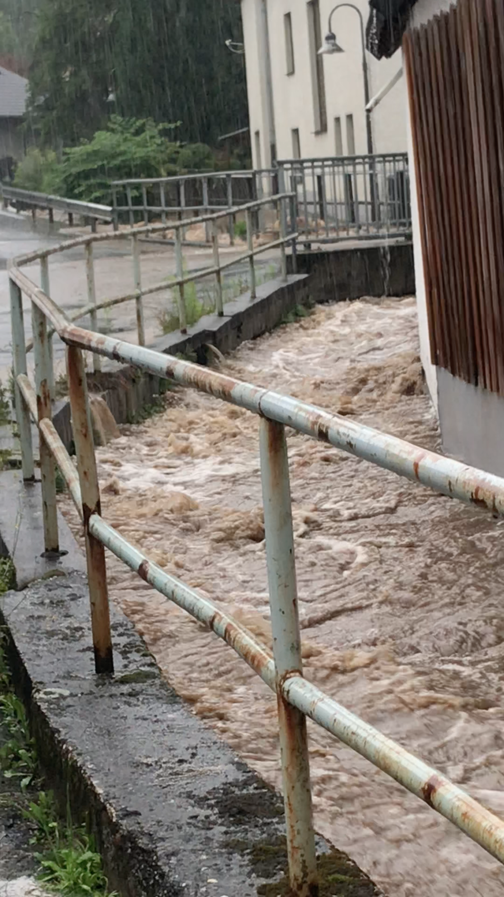
Garbach (left tributary of Hönne River) in Balve-Garbeck, Germany shortly before flooding the streets (07/14/2021)
Summary
[edit]_in_Balve-Garbeck_vor_%C3%9Cberflutung_der_Stra%C3%9Fe.png&action=edit§ion=1)
| Description |
English: In this picture, one can see the Garbach brook, a left tributary of the Hönne River (which flows over Ruhr and Rhine into the North Sea), shortly before it exceeds its riverbed. The picture was taken in Balve-Garbeck, North Rhine - Westphalia, Germany on July 14, 2021, 15:30 CEST as part of a video. It was later took as a screenshot from the video. July 14, 2021 was the day of the most heavy rainfalls and floodings in western Germany in decades. In the background, there is a bridge. The small village brook already reaches the bottom of the bridge's roadway slab. Waves are visible hitting the bridge. Upstream, the creek was already overflowing its banks at the time because another bridge was not letting enough water through. Hours later, the central roads of the village of Garbeck were flooded. Basements were full of water. Luckily, no one died in Garbeck. Other places were hit severely harder. Over 180 people lost their lives in Germany (as of July 18, 2020).
Deutsch: In diesem Bild sieht man den Garbach, einen linken Nebenfluss des Flusses Hönne (Abfluss über Rhein und Ruhr in die Nordsee), kurz bevor er über die Ufer tritt.
Das Foto wurde in Balve-Garbeck im Märkischen Kreis (NRW) aufgenommen. Es war der Nachmittag des 14. Juli 2021 gegen 15:30, der Tag der heftigsten Regenfälle und Fluten in Westdeutschland seit Jahrzehnten. Im Hintergrund ist eine Brücke zu sehen. Der kleine Dorfbach erreicht bereits den Boden der Fahrbahnplatte der Brücke. Es sind Wellen zu sehen, die gegen die Brücke schlagen. Flussaufwärts war der Bach zu diesem Zeitpunkt bereits über die Ufer getreten, weil eine andere Brücke nicht genug Wasser durchließ. Stunden später war die Dorfstraße Garbecks überflutet. Keller liefen voll mit Wasser. Glücklicherweise kam in Garbeck niemand ums Leben. Andere Orte traf es deutlich härter. Über 180 Menschen verloren in Deutschland ihr Leben in den Fluten (Stand 18. Juli 2020). |
| Date | |
| Source | Own work |
| Author | Pagabei |
| Camera location | | View this and other nearby images on: OpenStreetMap |
|---|
_in_Balve-Garbeck_vor_%C3%9Cberflutung_der_Stra%C3%9Fe.png¶ms=051.316902_N_0007.830480_E_globe:Earth_type:camera_heading:240.00&language=en)
Screenshot from self-filmed video Bildschirmfoto aus selbst gedrehtem Video
Licensing
[edit]_in_Balve-Garbeck_vor_%C3%9Cberflutung_der_Stra%C3%9Fe.png&action=edit§ion=2)
I, the copyright holder of this work, hereby publish it under the following license:
This file is licensed under the Creative Commons Attribution-Share Alike 4.0 International license.
- You are free:
- to share – to copy, distribute and transmit the work
- to remix – to adapt the work
- Under the following conditions:
- attribution – You must give appropriate credit, provide a link to the license, and indicate if changes were made. You may do so in any reasonable manner, but not in any way that suggests the licensor endorses you or your use.
- share alike – If you remix, transform, or build upon the material, you must distribute your contributions under the same or compatible license as the original.
File history
Click on a date/time to view the file as it appeared at that time.
| Date/Time | Thumbnail | Dimensions | User | Comment | |
|---|---|---|---|---|---|
| current | 23:07, 18 July 2021 | | 1,012 × 1,800 (2.96 MB) | Pagabei (talk | contribs) | Uploaded own work with UploadWizard |
You cannot overwrite this file.
File usage on Commons
There are no pages that use this file.
_in_Balve-Garbeck_vor_Überflutung_der_Straße.png&oldid=581998570)