File:Gap in the Hedgerow - geograph.org.uk - 1543321.jpg
Jump to navigation
Jump to search
Size of this preview: 450 × 600 pixels. Other resolutions: 180 × 240 pixels | 480 × 640 pixels.
Original file (480 × 640 pixels, file size: 89 KB, MIME type: image/jpeg)
Captions
Captions
Add a one-line explanation of what this file represents
Summary
[edit]| Description |
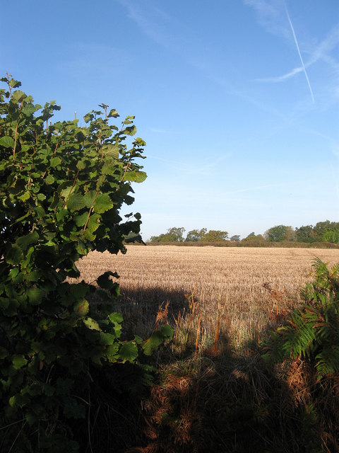
English: Gap in the Hedgerow Allowing a peak into the field to the west of the bridleway that links Chiltington to Warningore Wood. It is noticeable that the level of the field is higher than the bridleway which has been formed by two different processes over the centuries. The first is the use of the bridleway as a drove road tramped up and down by countless farmers and their herds of livestock which gradually flattens the highway down. In the meantime the ploughing of the field raises the level of the field by throwing up the earth to the side, though it is not as pronounced as some where the head of the field was used as a turning point which would through up even more earth, which was added to by the dumping of any boulders or stones uncovered during the ploughing. Much of this earth was fashioned into embankments and planted with hedgerows to prevent animals either getting in or out of the field. |
| Date | |
| Source | From geograph.org.uk |
| Author | Simon Carey |
| Attribution (required by the license) | Simon Carey / Gap in the Hedgerow / |
| Camera location | | View this and other nearby images on: OpenStreetMap |
|---|
| Object location | | View this and other nearby images on: OpenStreetMap |
|---|
Licensing
[edit]
|
This image was taken from the Geograph project collection. See this photograph's page on the Geograph website for the photographer's contact details. The copyright on this image is owned by Simon Carey and is licensed for reuse under the Creative Commons Attribution-ShareAlike 2.0 license.
|
This file is licensed under the Creative Commons Attribution-Share Alike 2.0 Generic license.
Attribution: Simon Carey
- You are free:
- to share – to copy, distribute and transmit the work
- to remix – to adapt the work
- Under the following conditions:
- attribution – You must give appropriate credit, provide a link to the license, and indicate if changes were made. You may do so in any reasonable manner, but not in any way that suggests the licensor endorses you or your use.
- share alike – If you remix, transform, or build upon the material, you must distribute your contributions under the same or compatible license as the original.

_heading:292.00&language=en)
_heading:292.00&language=en)
File history
Click on a date/time to view the file as it appeared at that time.
| Date/Time | Thumbnail | Dimensions | User | Comment | |
|---|---|---|---|---|---|
| current | 09:49, 3 March 2011 | | 480 × 640 (89 KB) | GeographBot (talk | contribs) | == {{int:filedesc}} == {{Information |description={{en|1=Gap in the Hedgerow Allowing a peak into the field to the west of the bridleway that links Chiltington to Warningore Wood. It is noticeable that the level of the field is higher than the bridleway w |
You cannot overwrite this file.
File usage on Commons
There are no pages that use this file.