File:Gantz Neue Und Vollstaendige Geographische General-Charte Vom Gantzen Churfürstenthum Sachsen Zusatz.jpg
Jump to navigation
Jump to search
Size of this preview: 430 × 599 pixels. Other resolutions: 172 × 240 pixels | 344 × 480 pixels | 551 × 768 pixels | 734 × 1,024 pixels | 1,469 × 2,048 pixels | 2,612 × 3,641 pixels.
Original file (2,612 × 3,641 pixels, file size: 1.82 MB, MIME type: image/jpeg)
Captions
Captions
Add a one-line explanation of what this file represents
Summary
[edit]
| Description |
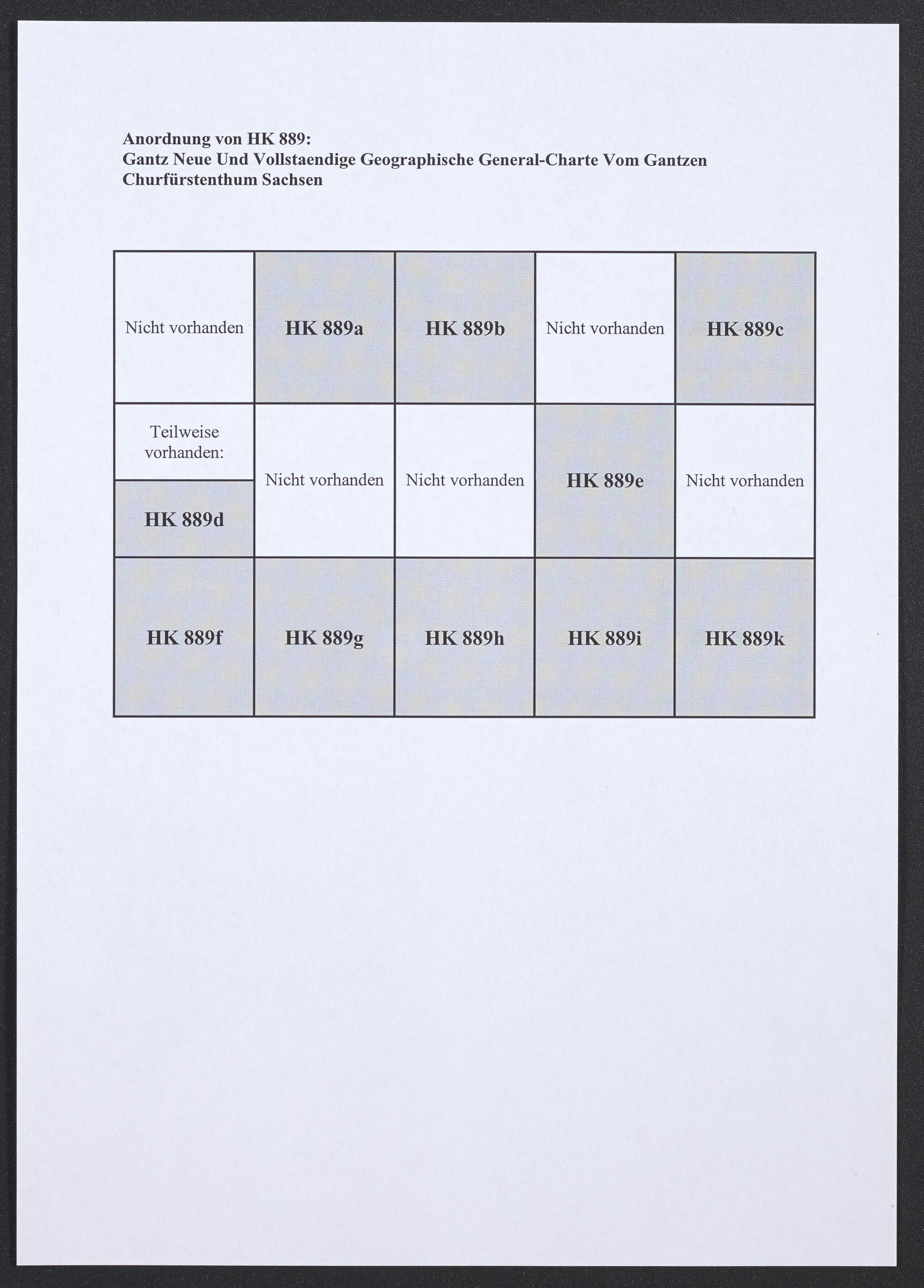
Deutsch: 1 Kt. auf 15 Bl. : teilw. Grenzen kolor. (Gesamtgr. 222 x 161 cm, je Teil versch. Gr.) ; Koordinaten E 11°18'59"-E 12°20'50"/N 52°10'25"-N 51°40'31" ; Kt. nicht vollst. vorhanden: 5 Teile fehlen, 1 Teil nur teilw. vorh. - Maßstab in graph. Form (Teutsche Meilen). - Maßstab und Titelkartusche oben Mitte. - Erläuterungskartusche mit Legende unten links. - Nullmeridian: Ferro. - Relief: Mit Bergschraffen ; Zusatz dient zur Kartenordnung |
| Date | between 1764 and 1767 |
| Source | Leibniz-Institut für Länderkunde e.V., Leipzig |
| Author | Petri, Isaak Jakob von ; Schleuen, Johann David |
Altkarte ; Übersichtskarte
Licensing
[edit]
| This file is made available under the Creative Commons CC0 1.0 Universal Public Domain Dedication. | |
| The person who associated a work with this deed has dedicated the work to the public domain by waiving all of their rights to the work worldwide under copyright law, including all related and neighboring rights, to the extent allowed by law. You can copy, modify, distribute and perform the work, even for commercial purposes, all without asking permission.
|
File history
Click on a date/time to view the file as it appeared at that time.
| Date/Time | Thumbnail | Dimensions | User | Comment | |
|---|---|---|---|---|---|
| current | 13:12, 6 December 2018 | | 2,612 × 3,641 (1.82 MB) | Higgenhorscht (talk | contribs) | User created page with UploadWizard |
You cannot overwrite this file.
File usage on Commons
There are no pages that use this file.