File:Galgenscheid Flur.jpg
Jump to navigation
Jump to search

Size of this preview: 799 × 366 pixels. Other resolutions: 320 × 147 pixels | 640 × 293 pixels | 1,024 × 469 pixels | 1,280 × 586 pixels | 2,362 × 1,082 pixels.
Original file (2,362 × 1,082 pixels, file size: 2.64 MB, MIME type: image/jpeg)
Captions
Captions
Add a one-line explanation of what this file represents
Summary
[edit]
| Description |
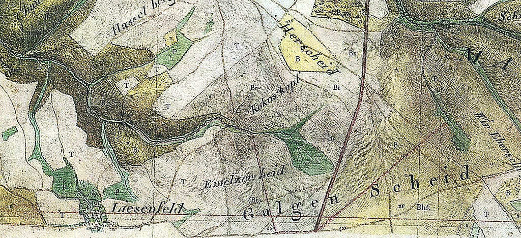
Deutsch: Vemutl. erste geometrische Darstellung des Richtstätten-Geländes Gallscheider Gerichtauf dem Vorderhunsrück |
| Date | 1810/11-1819 |
| Source | Scann-Repro von Kartenblatt 161 Boppard aus der Kartenaufnahme der Rheinlande durch Tranchot und v. Müffling 1803-1820 (Ausschnitt) |
| Author | Ing.- Geograph Dumesnil, preußische Endausführung Leutnant Fromholz |
Licensing
[edit]
|
This work is in the public domain in its country of origin and other countries and areas where the copyright term is the author's life plus 70 years or fewer. | |
| This file has been identified as being free of known restrictions under copyright law, including all related and neighboring rights. | |
Original upload log
[edit]
Transferred from de.wikipedia to Commons by Wdwdbot using script bot_filetrans.pl.
The original description page was here. All following user names refer to de.wikipedia.
- 2015-05-12 16:27:27 Dieter rogge (2772168 Bytes) {{Information |Beschreibung = Vemutl. erste geometrische Darstellung des Richtstätten-Geländes [[Gallscheider Gericht]]auf dem Vorderhunsrück |Quelle = Scann-Repro von Kartenblatt 161 Boppard aus der Kartenaufnahme der Rheinlande durch…
File history
Click on a date/time to view the file as it appeared at that time.
| Date/Time | Thumbnail | Dimensions | User | Comment | |
|---|---|---|---|---|---|
| current | 22:34, 13 May 2015 | | 2,362 × 1,082 (2.64 MB) | Wdwdbot (talk | contribs) | Bot Move: Original uploader of this revision (#1) was Dieter rogge at de.wikipedia |
You cannot overwrite this file.
File usage on Commons
There are no pages that use this file.
File usage on other wikis
The following other wikis use this file:
- Usage on de.wikipedia.org