File:Galgen bei Messern II.jpg
Original file (4,500 × 3,000 pixels, file size: 4.81 MB, MIME type: image/jpeg)
Captions
Summary
[edit]DescriptionGalgen bei Messern II.jpg |
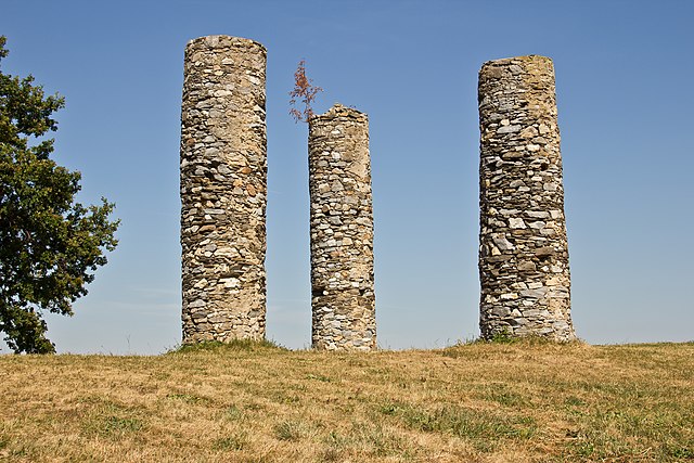
Deutsch: Auf dem Galgenberg nordwestlich des Ortes befindet sich eine weithin sichtbare mittelalterliche Richtstätte, von der drei gemauerte Rundpfeiler mit Pfostenlöchern erhalten sind. |
Date | |
Source | Own work |
Author | Duke of W4 |
Camera location | 48° 43′ 53.09″ N, 15° 30′ 22.82″ E | View this and other nearby images on: OpenStreetMap | 48.731413; 15.506338 |
---|
Object location | 48° 43′ 53.04″ N, 15° 30′ 23.15″ E | View this and other nearby images on: OpenStreetMap | 48.731400; 15.506430 |
---|
Licensing
[edit]- You are free:
- to share – to copy, distribute and transmit the work
- to remix – to adapt the work
- Under the following conditions:
- attribution – You must give appropriate credit, provide a link to the license, and indicate if changes were made. You may do so in any reasonable manner, but not in any way that suggests the licensor endorses you or your use.
- share alike – If you remix, transform, or build upon the material, you must distribute your contributions under the same or compatible license as the original.
This image was uploaded as part of Wiki Loves Monuments 2013.
Afrikaans ∙ Alemannisch ∙ azərbaycanca ∙ Bahasa Indonesia ∙ Bahasa Melayu ∙ Bikol Central ∙ bosanski ∙ brezhoneg ∙ català ∙ čeština ∙ Cymraeg ∙ dansk ∙ davvisámegiella ∙ Deutsch ∙ eesti ∙ English ∙ español ∙ Esperanto ∙ euskara ∙ français ∙ Frysk ∙ Gaeilge ∙ galego ∙ hrvatski ∙ Ido ∙ italiano ∙ latviešu ∙ Lëtzebuergesch ∙ Malagasy ∙ magyar ∙ Malti ∙ Nederlands ∙ norsk ∙ norsk nynorsk ∙ norsk bokmål ∙ polski ∙ português ∙ português do Brasil ∙ română ∙ shqip ∙ sicilianu ∙ slovenčina ∙ slovenščina ∙ suomi ∙ svenska ∙ Tagalog ∙ Türkçe ∙ Yorùbá ∙ Zazaki ∙ Ελληνικά ∙ беларуская ∙ беларуская (тарашкевіца) ∙ български ∙ кыргызча ∙ македонски ∙ русский ∙ српски / srpski ∙ українська ∙ ქართული ∙ հայերեն ∙ नेपाली ∙ हिन्दी ∙ বাংলা ∙ മലയാളം ∙ ไทย ∙ 한국어 ∙ +/− |
File history
Click on a date/time to view the file as it appeared at that time.
Date/Time | Thumbnail | Dimensions | User | Comment | |
---|---|---|---|---|---|
current | 15:45, 11 September 2013 | 4,500 × 3,000 (4.81 MB) | Duke of W4 (talk | contribs) | User created page with UploadWizard |
You cannot overwrite this file.
File usage on Commons
The following 3 pages use this file:
File usage on other wikis
The following other wikis use this file:
- Usage on de.wikipedia.org
- Irnfritz-Messern
- Liste der denkmalgeschützten Objekte in Irnfritz-Messern
- Wikipedia:Wiki Loves Monuments 2013/Österreich/Inhalt
- Wikipedia:Wiki Loves Monuments Österreich/WLM 2013
- Wikipedia:Wiki Loves Monuments 2014/Österreich
- Wikipedia:Wiki Loves Monuments 2014/Österreich/Inhalt
- Messern (Gemeinde Irnfritz-Messern)
- Wikipedia:WikiProjekt Österreich/checks/Denkmalschutz/WP - WD diffs 03
- Usage on nl.wikipedia.org
Metadata
This file contains additional information such as Exif metadata which may have been added by the digital camera, scanner, or software program used to create or digitize it. If the file has been modified from its original state, some details such as the timestamp may not fully reflect those of the original file. The timestamp is only as accurate as the clock in the camera, and it may be completely wrong.
Camera manufacturer | Canon |
---|---|
Camera model | Canon EOS 60D |
Author | Duke of W4 |
Exposure time | 1/250 sec (0.004) |
F-number | f/10 |
ISO speed rating | 100 |
Date and time of data generation | 15:48, 16 August 2013 |
Lens focal length | 33 mm |
Latitude | 48° 43′ 53.09″ N |
Longitude | 15° 30′ 22.82″ E |
Altitude | 536 meters above sea level |
Orientation | Normal |
Horizontal resolution | 240 dpi |
Vertical resolution | 240 dpi |
Software used | Adobe Photoshop Elements 8.0 Windows |
File change date and time | 17:38, 11 September 2013 |
Exposure Program | Normal program |
Exif version | 2.3 |
Date and time of digitizing | 15:48, 16 August 2013 |
APEX shutter speed | 7.965784 |
APEX aperture | 6.643856 |
APEX exposure bias | 0.33333333333333 |
Maximum land aperture | 4.25 APEX (f/4.36) |
Subject distance | 7.94 meters |
Metering mode | Pattern |
Flash | Flash did not fire, compulsory flash suppression |
DateTime subseconds | 63 |
DateTimeOriginal subseconds | 63 |
DateTimeDigitized subseconds | 63 |
Color space | sRGB |
Focal plane X resolution | 5,728.1767955801 |
Focal plane Y resolution | 5,808.4033613445 |
Focal plane resolution unit | inches |
Custom image processing | Normal process |
Exposure mode | Auto exposure |
White balance | Manual white balance |
Scene capture type | Standard |
GPS time (atomic clock) | 13:48 |
Geodetic survey data used | WGS-84 |
GPS date | 16 August 2013 |
GPS tag version | 0.0.2.2 |
Lens used | EF-S18-135mm f/3.5-5.6 IS |
Serial number of camera | 1380948212 |
Image width | 4,500 px |
Image height | 3,000 px |
Date metadata was last modified | 19:38, 11 September 2013 |
Unique ID of original document | xmp.did:25619138F81AE3119640EE815FE8E1FA |
IIM version | 23,439 |
Structured data
Items portrayed in this file
depicts
16 August 2013
48°43'53.08504"N, 15°30'22.81853"E
48°43'53.04"N, 15°30'23.15"E
0.004 second
10
33 millimetre
100
image/jpeg
- Cultural heritage monuments in Austria with known IDs
- CC-BY-SA-3.0-AT
- Self-published work
- Images from Wiki Loves Monuments 2013
- Images from Wiki Loves Monuments 2013 in Austria
- Cultural heritage monuments in Austria check done
- Uploaded via Campaign:wlm-at
- Winners of Wiki Loves Monuments 2013 in Austria
- Austria photographs taken on 2013-08-16