File:Gaelic Games County Map.svg
Jump to navigation
Jump to search

Size of this PNG preview of this SVG file: 424 × 600 pixels. Other resolutions: 170 × 240 pixels | 339 × 480 pixels | 543 × 768 pixels | 724 × 1,024 pixels | 1,448 × 2,048 pixels | 744 × 1,052 pixels.
Original file (SVG file, nominally 744 × 1,052 pixels, file size: 1.08 MB)
Captions
Captions
Add a one-line explanation of what this file represents
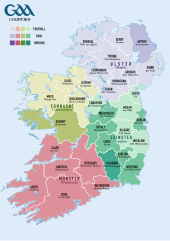
| Description | Counties contesting the All-Ireland Senior Football Championship (yellow), All-Ireland Senior Hurling Championship (blue), or both (green) |
| Date | (UTC) |
| Source | |
| Author |
|
| This is a retouched picture, which means that it has been digitally altered from its original version. Modifications: Altered colours of counties and legend. The original can be viewed here: Population density of Ireland map2002.svg:
|
I, the copyright holder of this work, hereby publish it under the following license:
| I, the copyright holder of this work, release this work into the public domain. This applies worldwide. In some countries this may not be legally possible; if so: I grant anyone the right to use this work for any purpose, without any conditions, unless such conditions are required by law. |
Original upload log
[edit]
This image is a derivative work of the following images:
- File:Population_density_of_Ireland_map2002.svg licensed with PD-self
- 2009-10-17T14:30:14Z The Illusional Ministry 800x1000 (635831 Bytes) Dublin now in black text
- 2009-10-17T14:27:13Z The Illusional Ministry 800x1000 (636262 Bytes) {{Information |Description=Map of Ireland's population density (people per km2). Based upon Republic of Ireland - 2002 Census results. |Source=*[[:File:Ireland_complete.svg|]] |Date=2009-10-17 14:25 (UTC) |Author=*[[:File:Ire
Uploaded with derivativeFX
File history
Click on a date/time to view the file as it appeared at that time.
| Date/Time | Thumbnail | Dimensions | User | Comment | |
|---|---|---|---|---|---|
| current | 09:49, 6 January 2019 | | 744 × 1,052 (1.08 MB) | XrysD (talk | contribs) | Fixed typo: Offlay-->Offaly |
| 18:22, 7 July 2018 |  | 744 × 1,052 (1.08 MB) | XrysD (talk | contribs) | Added missing province names. Converted remaining text to shapes. | |
| 18:14, 7 July 2018 |  | 744 × 1,052 (1.03 MB) | XrysD (talk | contribs) | Updated version based on File:Ireland_trad_counties_named.svg. New version has actual GAA borders which are based on 1884 counties with some changes. Also different provinces have been made clearer through use of ColorBrewer colour palette. Made map dual language by adding Irish county and province names. | |
| 14:53, 22 March 2016 |  | 800 × 1,000 (481 KB) | ELIincapitals (talk | contribs) | Reverted to version as of 14:45, 22 March 2016 (UTC) | |
| 14:48, 22 March 2016 |  | 800 × 1,000 (481 KB) | ELIincapitals (talk | contribs) | Reverted to version as of 14:42, 22 March 2016 (UTC) | |
| 14:46, 22 March 2016 |  | 800 × 1,000 (481 KB) | ELIincapitals (talk | contribs) | Reverted to version as of 14:45, 22 March 2016 (UTC) | |
| 14:45, 22 March 2016 |  | 800 × 1,000 (481 KB) | ELIincapitals (talk | contribs) | Reverted to version as of 14:42, 22 March 2016 (UTC) | |
| 14:45, 22 March 2016 |  | 800 × 1,000 (481 KB) | ELIincapitals (talk | contribs) | Changed Kerry to a duel county seeing as they now compete in the Leinster championship. *http://www.gaa.ie/hurling/leinster-gaa-hurling-senior-championship/ | |
| 14:42, 22 March 2016 |  | 800 × 1,000 (481 KB) | ELIincapitals (talk | contribs) | Changed Kerry to a duel county seeing as they now compete in the Leinster championship. *http://www.gaa.ie/hurling/leinster-gaa-hurling-senior-championship/ | |
| 08:55, 15 August 2011 |  | 800 × 1,000 (481 KB) | Rwxrwxrwx (talk | contribs) | Fixed county name to Derry. This is not a political map but a map of the GAA's county divisions, where is it always Derry. See http://gaa.ie/about-the-gaa/provinces-and-counties/about-county/ . |
You cannot overwrite this file.
File usage on Commons
The following 4 pages use this file:
File usage on other wikis
The following other wikis use this file:
- Usage on arz.wikipedia.org
- Usage on en.wikipedia.org
- Usage on eo.wikipedia.org
- Usage on es.wikipedia.org
- Usage on eu.wikipedia.org
- Usage on it.wikipedia.org
- Usage on pl.wikipedia.org
- Usage on ru.wikipedia.org
- Usage on www.wikidata.org
- Usage on zh.wikipedia.org