File:Gadental 4 Alpen.JPG
From Wikimedia Commons, the free media repository
Jump to navigation
Jump to search
Size of this preview: 800 × 533 pixels. Other resolutions: 320 × 213 pixels | 640 × 427 pixels | 1,024 × 683 pixels | 1,280 × 853 pixels | 2,560 × 1,707 pixels | 4,800 × 3,200 pixels.
Original file (4,800 × 3,200 pixels, file size: 7.16 MB, MIME type: image/jpeg)
File information
Structured data
Captions
DescriptionGadental 4 Alpen.JPG |
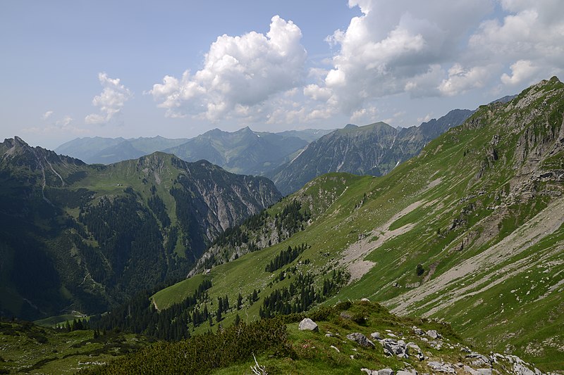
Deutsch: Unter dem Mutterwangjoch (Mutawangjoch) das das Metzgertobel mit dem Gadental verbindet sieht man alle vier Alpen des Auf dem Weg zum Gadentales. Links oben, unter der Wangspitze liegt die Matonaalpe. Auf gleicher Höhe befindet sich visa vis die Stellialpe auf einem Sattel. In der unteren linken Bildmitte ist die Disnerbergalpe und am linken Bildrand erkennt man noch die drei Dächer der Gadneralpe. |
||
Date | |||
Source | Own work | ||
Author |
|
||
Permission (Reusing this file) |
I, the copyright holder of this work, hereby publish it under the following license: This file is licensed under the Creative Commons Attribution-Share Alike 3.0 Austria license.
|
Camera location | 47° 13′ 24.3″ N, 10° 00′ 35.84″ E | View this and other nearby images on: OpenStreetMap | 47.223417; 10.009956 |
---|
Annotations InfoField | This image is annotated: View the annotations at Commons |
1308
1267
48
48
4800
3200
Wangspitze
2082
1003
48
48
4800
3200
Glatthorn
972
1549
78
60
4800
3200
Matonaalpe
426
2756
156
78
4800
3200
Gadenalpe
1728
2275
90
84
4800
3200
Disnerbergalpe
3144
1477
84
78
4800
3200
Stellialpe
4656
588
48
48
4800
3200
Feuerstein
File history
Click on a date/time to view the file as it appeared at that time.
Date/Time | Thumbnail | Dimensions | User | Comment | |
---|---|---|---|---|---|
current | 21:07, 28 August 2013 | 4,800 × 3,200 (7.16 MB) | Böhringer (talk | contribs) | {{Information |Description= {{de| Unter dem Mutterwangjoch (Mutawangjoch) das das Metzgertobel mit dem Gadental verbindet sieht man alle vier Alpen des Auf dem Weg zum Gadentales. Links oben, unter der Wangspitze liegt die Matonaalpe. ... |
You cannot overwrite this file.
File usage on Commons
The following page uses this file:
File usage on other wikis
The following other wikis use this file:
- Usage on de.wikipedia.org
- Usage on ro.wikipedia.org
- Usage on www.wikidata.org
Metadata
This file contains additional information such as Exif metadata which may have been added by the digital camera, scanner, or software program used to create or digitize it. If the file has been modified from its original state, some details such as the timestamp may not fully reflect those of the original file. The timestamp is only as accurate as the clock in the camera, and it may be completely wrong.
Camera manufacturer | NIKON CORPORATION |
---|---|
Camera model | NIKON D800E |
Author | rufre@lenz-nennig.at |
Copyright holder | Boehringer Friedrich [Fred] |
Exposure time | 1/200 sec (0.005) |
F-number | f/7.1 |
Date and time of data generation | 14:18, 13 July 2013 |
Lens focal length | 17 mm |
User comments | Nenne den Autor! |
Orientation | Normal |
Horizontal resolution | 300 dpi |
Vertical resolution | 300 dpi |
Software used | Ver.1.01 |
File change date and time | 14:18, 13 July 2013 |
Y and C positioning | Co-sited |
Exposure Program | Normal program |
Exif version | 2.3 |
Date and time of digitizing | 14:18, 13 July 2013 |
Meaning of each component |
|
Image compression mode | 4 |
APEX exposure bias | 0 |
Maximum land aperture | 3 APEX (f/2.83) |
Metering mode | Pattern |
Light source | Unknown |
Flash | Flash did not fire, compulsory flash suppression |
DateTime subseconds | 50 |
DateTimeOriginal subseconds | 50 |
DateTimeDigitized subseconds | 50 |
Supported Flashpix version | 1 |
Color space | sRGB |
Sensing method | One-chip color area sensor |
File source | Digital still camera |
Scene type | A directly photographed image |
Custom image processing | Normal process |
Exposure mode | Auto exposure |
White balance | Auto white balance |
Digital zoom ratio | 1.53 |
Focal length in 35 mm film | 25 mm |
Scene capture type | Standard |
Scene control | None |
Contrast | Normal |
Saturation | Normal |
Sharpness | Normal |
Subject distance range | Unknown |
GPS tag version | 2.3.0.0 |