File:GOES 12 Eastern US image 12212013.JPG
GOES_12_Eastern_US_image_12212013.JPG (640 × 480 pixels, file size: 72 KB, MIME type: image/jpeg)
Captions
Captions
Summary
[edit]
| Description |
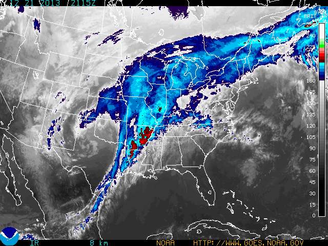
English: GOES Eastern US SECTOR Infrared Image
Meteorologists use color enhanced imagery as an aid in satellite interpretation. The colors enable them to easily and quickly see features which are of special interest. Usually they look for high clouds or areas with a large amount of water vapor. In an infrared (IR) image cold clouds are high clouds, so the colors typically highlight the colder regions. The bar on the right side of the image indicates the pixel brightness values for the corresponding color. The temperature can be determined from the following formulas: For B > 176 T = 418 - B or when B <=176 T = 330 - (B/2) Note that the resulting temperatures are in Kelvin. For IR data, the highest pixel values correspond to the coldest temperatures. |
| Date | |
| Source | http://www.goes.noaa.gov/ECIR4.html |
| Author | US NOAA |
Licensing
[edit]
This image is in the public domain because it contains materials that originally came from the U.S. National Oceanic and Atmospheric Administration, taken or made as part of an employee's official duties.
|
File history
Click on a date/time to view the file as it appeared at that time.
| Date/Time | Thumbnail | Dimensions | User | Comment | |
|---|---|---|---|---|---|
| current | 22:16, 21 December 2013 | | 640 × 480 (72 KB) | Oaktree b (talk | contribs) | User created page with UploadWizard |
You cannot overwrite this file.
File usage on Commons
The following 2 pages use this file:
File usage on other wikis
The following other wikis use this file:
- Usage on fr.wikipedia.org
- Usage on www.wikidata.org