File:GNW1020.jpg
Jump to navigation
Jump to search

Size of this preview: 800 × 534 pixels. Other resolutions: 320 × 214 pixels | 640 × 427 pixels | 1,024 × 683 pixels | 1,280 × 854 pixels | 2,560 × 1,708 pixels | 3,072 × 2,050 pixels.
Original file (3,072 × 2,050 pixels, file size: 1.03 MB, MIME type: image/jpeg)
Captions
Captions
Add a one-line explanation of what this file represents
Summary
[edit]
| Description |
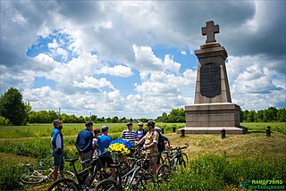
Українська: Велосипедна екскурсія-презентація «З картою в руці: поле Полтавської битви сьогодні» |
| Date | |
| Source | Own work |
| Author | Yurii-mr |
| Camera location | | View this and other nearby images on: OpenStreetMap |
|---|
Проєкт «Популяризація туристичного маршруту «Шляхами союзної армії шведського короля Карла ХІІ та гетьмана України Івана Мазепи: від Гадяча до Переволочної» в 2020 році від ГО «ВелоПолтава»
Licensing
[edit]
I, the copyright holder of this work, hereby publish it under the following license:
This file is licensed under the Creative Commons Attribution-Share Alike 4.0 International license.
- You are free:
- to share – to copy, distribute and transmit the work
- to remix – to adapt the work
- Under the following conditions:
- attribution – You must give appropriate credit, provide a link to the license, and indicate if changes were made. You may do so in any reasonable manner, but not in any way that suggests the licensor endorses you or your use.
- share alike – If you remix, transform, or build upon the material, you must distribute your contributions under the same or compatible license as the original.
File history
Click on a date/time to view the file as it appeared at that time.
| Date/Time | Thumbnail | Dimensions | User | Comment | |
|---|---|---|---|---|---|
| current | 13:55, 18 January 2021 | | 3,072 × 2,050 (1.03 MB) | Yurii-mr (talk | contribs) | Uploaded own work with UploadWizard |
You cannot overwrite this file.
File usage on Commons
There are no pages that use this file.
File usage on other wikis
The following other wikis use this file:
- Usage on ru.wikipedia.org