File:GLO-624FA7 Medieval Barrel Padlock (FindID 826488).jpg
Jump to navigation
Jump to search
Size of this preview: 800 × 527 pixels. Other resolutions: 320 × 211 pixels | 640 × 422 pixels | 1,024 × 675 pixels | 1,280 × 843 pixels | 2,296 × 1,513 pixels.
Original file (2,296 × 1,513 pixels, file size: 859 KB, MIME type: image/jpeg)
Captions
Captions
Add a one-line explanation of what this file represents
Summary
[edit].jpg&action=edit§ion=1)
| GLO-624FA7 Medieval Barrel Padlock | |||
|---|---|---|---|
| Photographer |
Bristol City Council, Kurt Adams, 2017-02-02 13:36:30 |
||
| Title |
GLO-624FA7 Medieval Barrel Padlock |
||
| Description |
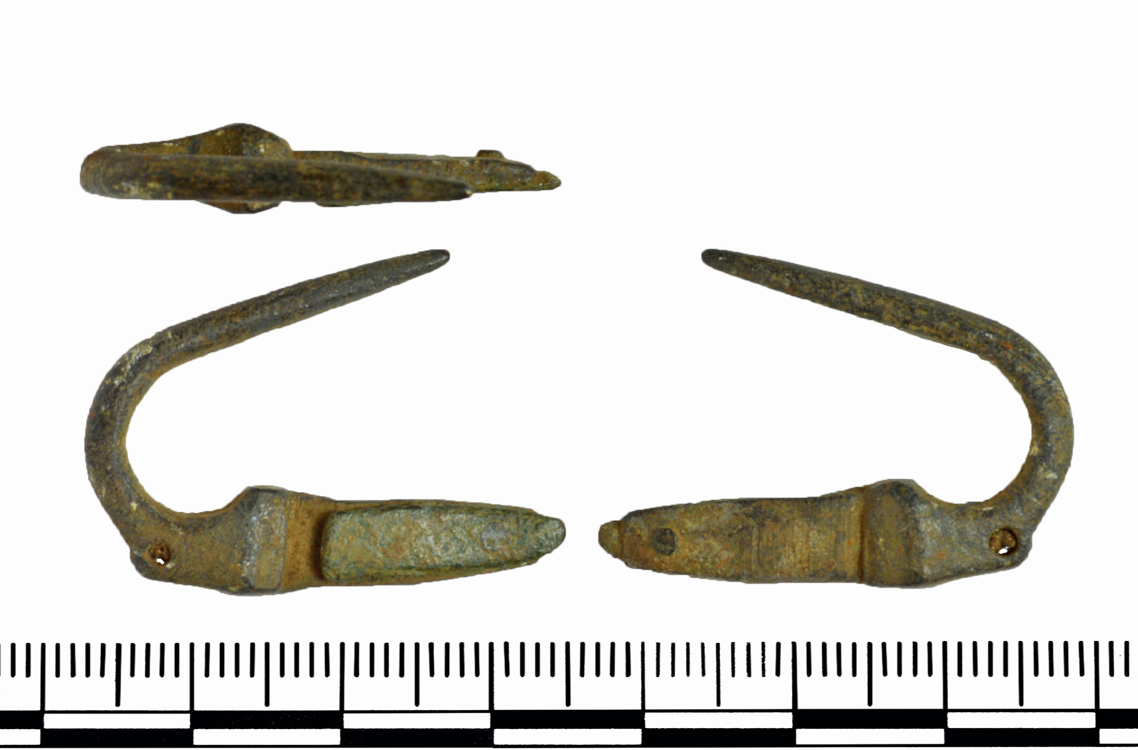
English: ~~Copper alloy barrel padlock bolt comprises of the spring element that would be inserted in to the hollow chamber of the padlock. This has a thin circular cross section shaft that would be inserted into external loops of the barrel, this curves back on itself to the lock that runs parallel to the shaft. The lock has an external loop at the base of the curve, followed by an expanded rectangular ridge on either side from which emanates the lock that is formed from a flat rectangular arm that has a rounded tip. Riveted to the end of this section (via a copper alloy rivet) is a sheet copper alloy plate on either side that forms the spring of the bolt (one spring is missing). |
||
| Depicted place | (County of findspot) Gloucestershire | ||
| Date | between 1200 and 1500 | ||
| Accession number |
FindID: 826488 Old ref: GLO-624FA7 Filename: GLO624FA7.jpg |
||
| Credit line |
|
||
| Source |
https://finds.org.uk/database/ajax/download/id/600018 Catalog: https://finds.org.uk/database/images/image/id/600018/recordtype/artefacts archive copy at the Wayback Machine Artefact: https://finds.org.uk/database/artefacts/record/id/826488 |
||
| Permission (Reusing this file) |
Attribution License | ||
| Object location | | View this and other nearby images on: OpenStreetMap |
|---|
.jpg¶ms=051.807300_N_-002.092970_E_globe:Earth_class:object_type:object__&language=en)
Licensing
[edit].jpg&action=edit§ion=2)
This file is licensed under the Creative Commons Attribution 2.0 Generic license.
Attribution: Bristol City Council
- You are free:
- to share – to copy, distribute and transmit the work
- to remix – to adapt the work
- Under the following conditions:
- attribution – You must give appropriate credit, provide a link to the license, and indicate if changes were made. You may do so in any reasonable manner, but not in any way that suggests the licensor endorses you or your use.
File history
Click on a date/time to view the file as it appeared at that time.
| Date/Time | Thumbnail | Dimensions | User | Comment | |
|---|---|---|---|---|---|
| current | 15:36, 18 December 2018 | | 2,296 × 1,513 (859 KB) | Fæ (talk | contribs) | Portable Antiquities Scheme, GLO, FindID: 826488, medieval, page 2405, batch count 21504 |
You cannot overwrite this file.
File usage on Commons
The following page uses this file:
.jpg)
.jpg&oldid=643503992)