File:GEOS-FP Near Surface Temperature (SVS5147).jpg
Jump to navigation
Jump to search
Size of this preview: 800 × 400 pixels. Other resolutions: 320 × 160 pixels | 640 × 320 pixels | 1,024 × 512 pixels.
Original file (1,024 × 512 pixels, file size: 160 KB, MIME type: image/jpeg)
Captions
Captions
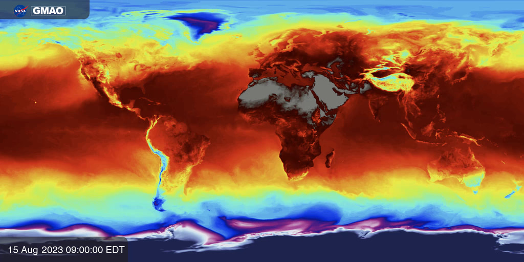
Near surface temperature is calculated by sampling 3-D atmospheric fields from NASA’s GEOS-FP system 3 meters above Earth’s surface.
Summary
[edit].jpg&action=edit§ion=1)
| Description |
English: Near surface temperature is calculated by sampling 3-D atmospheric fields from NASA’s GEOS-FP system 3 meters above Earth’s surface. GEOS-FP combines millions of weather observations with a predictive model to create a global best estimate of weather conditions that are used to begin a forecast. |
| Date | 26 September 2023 (upload date) |
| Source | GEOS-FP Near Surface Temperature |
| Author | NASA's Scientific Visualization Studio - NASA/GSFC/Joseph V. Ardizzone |
| Other versions |
|
| Keywords | GMAO; Hyperwall; Weather and Atmospheric Dynamics; Earth Information Center |
Licensing
[edit].jpg&action=edit§ion=2)
| This file is in the public domain in the United States because it was solely created by NASA. NASA copyright policy states that "NASA material is not protected by copyright unless noted". (See Template:PD-USGov, NASA copyright policy page or JPL Image Use Policy.) | ||
 |
Warnings:
|
File history
Click on a date/time to view the file as it appeared at that time.
| Date/Time | Thumbnail | Dimensions | User | Comment | |
|---|---|---|---|---|---|
| current | 14:12, 3 August 2024 | | 1,024 × 512 (160 KB) | OptimusPrimeBot (talk | contribs) | #Spacemedia - Upload of https://svs.gsfc.nasa.gov/vis/a000000/a005100/a005147/MC01_stage3_GMAO_near_surface_temperature_2048x1024_en.00001_print.jpg via Commons:Spacemedia |
You cannot overwrite this file.
File usage on Commons
The following page uses this file:
.jpg&oldid=906187294)