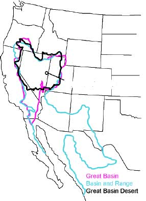
File:GB-Definition-Map.jpg
From Wikimedia Commons, the free media repository
Jump to navigation
Jump to search
GB-Definition-Map.jpg (286 × 392 pixels, file size: 17 KB, MIME type: image/jpeg)
File information
Structured data
Captions
Captions
Add a one-line explanation of what this file represents

|
This geology image could be re-created using vector graphics as an SVG file. This has several advantages; see Commons:Media for cleanup for more information. If an SVG form of this image is available, please upload it and afterwards replace this template with
{{vector version available|new image name}}.
It is recommended to name the SVG file “GB-Definition-Map.svg”—then the template Vector version available (or Vva) does not need the new image name parameter. |
 | This geology image was uploaded in the JPEG format even though it consists of non-photographic data. This information could be stored more efficiently or accurately in the PNG or SVG format. If possible, please upload a PNG or SVG version of this image without compression artifacts, derived from a non-JPEG source (or with existing artifacts removed). After doing so, please tag the JPEG version with {{Superseded|NewImage.ext}} and remove this tag. This tag should not be applied to photographs or scans. If this image is a diagram or other image suitable for vectorisation, please tag this image with {{Convert to SVG}} instead of {{BadJPEG}}. If not suitable for vectorisation, use {{Convert to PNG}}. For more information, see {{BadJPEG}}. |
Summary
[edit]| DescriptionGB-Definition-Map.jpg |
English: The Great Basin can be defined hydrographically (in purple), topographically (in blue), or biologically (in black). |
||||
| Date | 30 August 2006 (original upload date) | ||||
| Source | http://www.nps.gov/grba/planyourvisit/the-great-basin.htm | ||||
| Author | U.S. National Park Service | ||||
| Permission (Reusing this file) |
|
||||
| Other versions | cleaned-up gif version |
Original upload log
[edit]Transferred from en.wikipedia to Commons by Psemper.
- 2006-08-30 05:11 Bplewe 286×392×8 (17013 bytes) source: Great Basin National Park, http://www.nps.gov/grba/planyourvisit/the-great-basin.htm
File history
Click on a date/time to view the file as it appeared at that time.
| Date/Time | Thumbnail | Dimensions | User | Comment | |
|---|---|---|---|---|---|
| current | 05:24, 13 July 2015 |  | 286 × 392 (17 KB) | Hike395 (talk | contribs) | revert original research |
| 14:19, 4 January 2011 |  | 652 × 1,014 (138 KB) | Hike796 (talk | contribs) | +Great Basin tribes area | |
| 14:23, 2 January 2008 |  | 286 × 392 (17 KB) | Psemper (talk | contribs) | {{Information |Description= |Source=http://en.wikipedia.org/wiki/Image:GB-Definition-Map.jpg |Date= |Author= |Permission= |other_versions= }} |
You cannot overwrite this file.
File usage on Commons
The following page uses this file:


