File:Fussweg bsa schloss rothestein ds osm wv 07 2011.PNG
Jump to navigation
Jump to search
Size of this preview: 800 × 458 pixels. Other resolutions: 320 × 183 pixels | 640 × 367 pixels | 1,024 × 586 pixels | 1,507 × 863 pixels.
Original file (1,507 × 863 pixels, file size: 518 KB, MIME type: image/png)
Captions
Captions
Add a one-line explanation of what this file represents
Summary
[edit]
| Description |
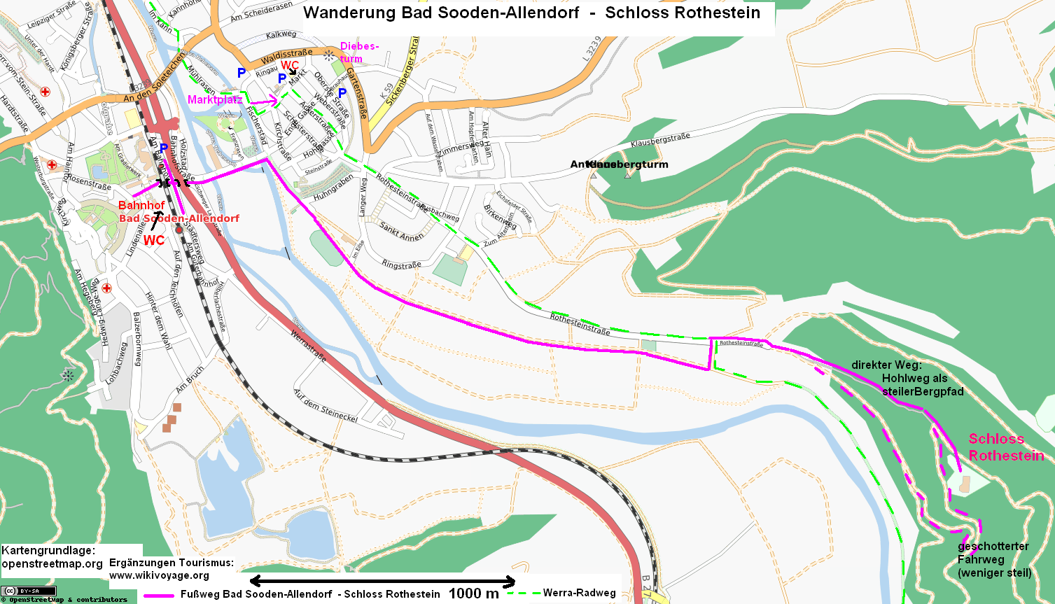
English: Bad Sooden Allendorf / Germany: map of walking-tour to castle Rothestein
Deutsch: Kassel: Wanderung Bad Sooden-Allendorf - Schloss Rothestein (gleichzeitig Fernwanderweg E6) (separat in Din A4 Querformat ausdrucken.) Ein Dank an die Kartografen von Openstreetmap für die Kartengrundlage. |
| Date | |
| Source |
English: based on map of openstreetmap.org
Deutsch: Karte auf Basis von openstreetmap.org |
| Author | Kartengrundlage: openstreetmap.org. Ergänzungen Tourismus: Dirk Schmidt (celsius) |
| Permission (Reusing this file) |
© OpenStreetMap contributors |
Licensing
[edit]
User: Celsius at wikivoyage shared, the copyright holder of this work, hereby publishes it under the following licenses:

|
Permission is granted to copy, distribute and/or modify this document under the terms of the GNU Free Documentation License, Version 1.2 or any later version published by the Free Software Foundation; with no Invariant Sections, no Front-Cover Texts, and no Back-Cover Texts. A copy of the license is included in the section entitled GNU Free Documentation License. |
This file is licensed under the Creative Commons Attribution-Share Alike 3.0 Unported, 2.5 Generic, 2.0 Generic and 1.0 Generic license.
Attribution: User: Celsius at wikivoyage shared
- You are free:
- to share – to copy, distribute and transmit the work
- to remix – to adapt the work
- Under the following conditions:
- attribution – You must give appropriate credit, provide a link to the license, and indicate if changes were made. You may do so in any reasonable manner, but not in any way that suggests the licensor endorses you or your use.
- share alike – If you remix, transform, or build upon the material, you must distribute your contributions under the same or compatible license as the original.
You may select the license of your choice.
Original upload log
[edit]
| This file was imported from Wikivoyage Shared. |
The original description page was here. All following user names refer to wikivoyage-old/shared.
- 2011-07-03 23:15 Celsius archive copy at the Wayback Machine 1507×863 (530717 bytes) {{Information |Description= {{en|Bad Sooden Allendorf / Germany: map of walking-tour to castle Rothestein}} {{de|Kassel: Wanderung Bad Sooden-Allendorf - Schloss Rothestein (separat in Din A4 Querformat ausdrucken.) Ein Dank an die Kartografen von Openstreetmap für die Kartengrundlage.}} |Author= Kartengrundlage: openstreetmap.org. Ergänzungen Tourismus: Dirk Schmidt (celsius) |Date= 07-2011 |Source= {{en|based on map of openstreetmap.org}} {{de|Karte auf Basis von openstreetmap.org}} |Permission= |other_versions= }} [[Category:Kassel/Karlsaue]] [[Category:Images by Celsius]]
File history
Click on a date/time to view the file as it appeared at that time.
| Date/Time | Thumbnail | Dimensions | User | Comment | |
|---|---|---|---|---|---|
| current | 06:22, 15 November 2012 | | 1,507 × 863 (518 KB) | MGA73bot2 (talk | contribs) | {{BotMoveToCommons|shared.oldwikivoyage|year={{subst:CURRENTYEAR}}|month={{subst:CURRENTMONTHNAME}}|day={{subst:CURRENTDAY}}}} == {{int:filedesc}} == {{Information |description={{en|Bad Sooden Allendorf / Germany: map of walking-tour to castle Rotheste... |
You cannot overwrite this file.
File usage on Commons
There are no pages that use this file.
File usage on other wikis
The following other wikis use this file:
- Usage on de.wikivoyage.org