File:Fusha e Tiranës 2008.jpg
Jump to navigation
Jump to search

Size of this preview: 800 × 576 pixels. Other resolutions: 320 × 230 pixels | 640 × 461 pixels | 1,024 × 737 pixels | 1,280 × 922 pixels | 2,500 × 1,800 pixels.
Original file (2,500 × 1,800 pixels, file size: 1.78 MB, MIME type: image/jpeg)
Captions
Captions
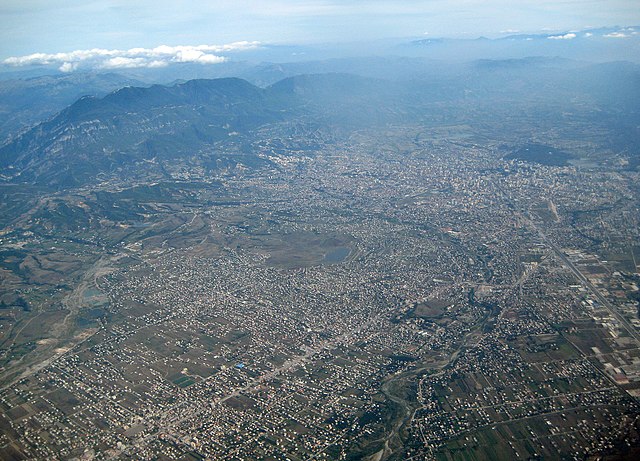
Aerial view of Tirana and surroundings
Summary
[edit]
| Description |
English: The Southern part of the Plain of Tirana (Albania). The mount Dajti at its Eastern end is in the upper left corner of the image. Tirana's high rise buildings and parks can be seen in the upper right corner. The motorway from Durrës in the West leading directly in Tirana's center is on the right hand side. From the lower left corner, the street from North Albania is heading to Tirana through the town of Kamza. Along this street, many new illegal settlements can be seen in the center of the picture. Between Kamza and Tirana, Tirana river makes its way to the Ocean (bottom center), as on the far left the River Zeza is to be recognized.
Deutsch: Der südliche Teil der Ebene von Tirana (Albanien) mit dem Berg Dajti links oben (Osten), den Hochhäusern und Grünflächen von Tirana rechts oben (Süden), der von Durrës im Westen herführenden Autobahn rechts, die als Hauptachse bis ins Stadtzentrum weitergeführt wird, dem Fluss Tirana unten, dem Fluss Zeza ganz links und der Strasse nach Norden unten links, entlang der rund um das Städtchen Kamza gewaltige Siedlungsflächen illegal überbaut wurden (Bildmitte) |
| Date | |
| Source | Own work |
| Author | Albinfo |
Licensing
[edit]
I, the copyright holder of this work, hereby publish it under the following license:
This file is licensed under the Creative Commons Attribution-Share Alike 3.0 Unported license.
- You are free:
- to share – to copy, distribute and transmit the work
- to remix – to adapt the work
- Under the following conditions:
- attribution – You must give appropriate credit, provide a link to the license, and indicate if changes were made. You may do so in any reasonable manner, but not in any way that suggests the licensor endorses you or your use.
- share alike – If you remix, transform, or build upon the material, you must distribute your contributions under the same or compatible license as the original.
| Annotations | This image is annotated: View the annotations at Commons |
File history
Click on a date/time to view the file as it appeared at that time.
| Date/Time | Thumbnail | Dimensions | User | Comment | |
|---|---|---|---|---|---|
| current | 11:38, 12 November 2008 | | 2,500 × 1,800 (1.78 MB) | Albinfo (talk | contribs) | {{Information |Description={{en|1=The Southern part of the Plain of Tirana (Albania). The mount Dajti at its Eastern end is in the upper left corner of the image. Tirana's high rise buildings and parks can be seen in the upper right corner. The motorway f |
You cannot overwrite this file.
File usage on Commons
There are no pages that use this file.
File usage on other wikis
The following other wikis use this file:
- Usage on ba.wikipedia.org
- Usage on be.wikipedia.org
- Usage on bg.wikipedia.org
- Usage on de.wikipedia.org
- Usage on en.wikipedia.org
- Usage on fa.wikipedia.org
- Usage on lv.wikipedia.org
- Usage on mdf.wikipedia.org
- Usage on mk.wikipedia.org
- Usage on mn.wikipedia.org
- Usage on rm.wikipedia.org
- Usage on ru.wikipedia.org
- Usage on sco.wikipedia.org
- Usage on sl.wikipedia.org
- Usage on sq.wikipedia.org
- Usage on sv.wikipedia.org
- Usage on zh.wikipedia.org