File:FukushimaGrid.JPG
FukushimaGrid.JPG (404 × 437 pixels, file size: 43 KB, MIME type: image/jpeg)
Captions
Captions
Summary
[edit]| DescriptionFukushimaGrid.JPG |
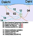
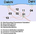
English: Transmission grid serving the two Fukushima nuclear power stations. This diagram is based on the Google Maps of the area, and was made by tracing the transmission towers across the land, from the switch yard at the two plants to the termination at the substation. Google Maps Version of the work available here.
The Shin-Fukushima (新福島) substation connects to the Fukushima Daini plant by the Tomioka Line (富岡線) and the Fukushima Daiichi plant by the Futaba Line (双葉線) and the Ookuma Lines (大熊線). Its major connection to the north is Iwaki Line (いわき幹線), which is owned by Tohoku Power. It has two paths to the south-west that connect it to TEPCO's Shin-Iwaki substation (新いわき). Reference: Tepco Annual Report 2003. Page 24. (Japanese). Also shown are Tomoku's distribution substation that serves Tomioka, Tohoku's Yonomori line from that substation to TEPCO's Fukushima Daiichi plant. |
| Date | |
| Source | Own work |
| Author | MartinGugino |
 | This image was uploaded in the JPEG format even though it consists of non-photographic data. This information could be stored more efficiently or accurately in the PNG or SVG format. If possible, please upload a PNG or SVG version of this image without compression artifacts, derived from a non-JPEG source (or with existing artifacts removed). After doing so, please tag the JPEG version with {{Superseded|NewImage.ext}} and remove this tag. This tag should not be applied to photographs or scans. If this image is a diagram or other image suitable for vectorisation, please tag this image with {{Convert to SVG}} instead of {{BadJPEG}}. If not suitable for vectorisation, use {{Convert to PNG}}. For more information, see {{BadJPEG}}. |
Licensing
[edit]- You are free:
- to share – to copy, distribute and transmit the work
- to remix – to adapt the work
- Under the following conditions:
- attribution – You must give appropriate credit, provide a link to the license, and indicate if changes were made. You may do so in any reasonable manner, but not in any way that suggests the licensor endorses you or your use.
| Annotations InfoField | This image is annotated: View the annotations at Commons |
Futaba Line (双葉線) 500KV
Ookuma Lines (大熊線) 275KV
Fukuoka Line (福岡線) 500KV
File history
Click on a date/time to view the file as it appeared at that time.
| Date/Time | Thumbnail | Dimensions | User | Comment | |
|---|---|---|---|---|---|
| current | 13:12, 9 May 2011 |  | 404 × 437 (43 KB) | MartinGugino (talk | contribs) | Add the TEPCO Yonomori line as a shared tower with the second Okuma towers |
| 21:02, 8 May 2011 |  | 404 × 437 (43 KB) | MartinGugino (talk | contribs) | Corrected name of line to Daini to Tomioka from Fukuoka. Added name in Japanese. Correct typos. | |
| 00:59, 8 May 2011 |  | 404 × 437 (41 KB) | MartinGugino (talk | contribs) | Add Tohoku's Iwaki line, and used colors. | |
| 21:15, 7 May 2011 |  | 433 × 415 (39 KB) | MartinGugino (talk | contribs) | added lines and substation owned by Tohoku | |
| 00:27, 10 April 2011 |  | 474 × 262 (17 KB) | MartinGugino (talk | contribs) | {{Information |Description ={{en|1=transmission grid serving the two Fukushima nuclear power stations}} |Source ={{own}} |Author =MartinGugino |Date =2011-04-09 |Permission = |other_versions = }} |
You cannot overwrite this file.
File usage on Commons
There are no pages that use this file.
File usage on other wikis
The following other wikis use this file:
Metadata
This file contains additional information such as Exif metadata which may have been added by the digital camera, scanner, or software program used to create or digitize it. If the file has been modified from its original state, some details such as the timestamp may not fully reflect those of the original file. The timestamp is only as accurate as the clock in the camera, and it may be completely wrong.
| _error | 0 |
|---|
