File:Ft Sumter 2016.07.13 (100).jpg
Original file (3,008 × 1,692 pixels, file size: 2.92 MB, MIME type: image/jpeg)
Captions
Summary
[edit]DescriptionFt Sumter 2016.07.13 (100).jpg |
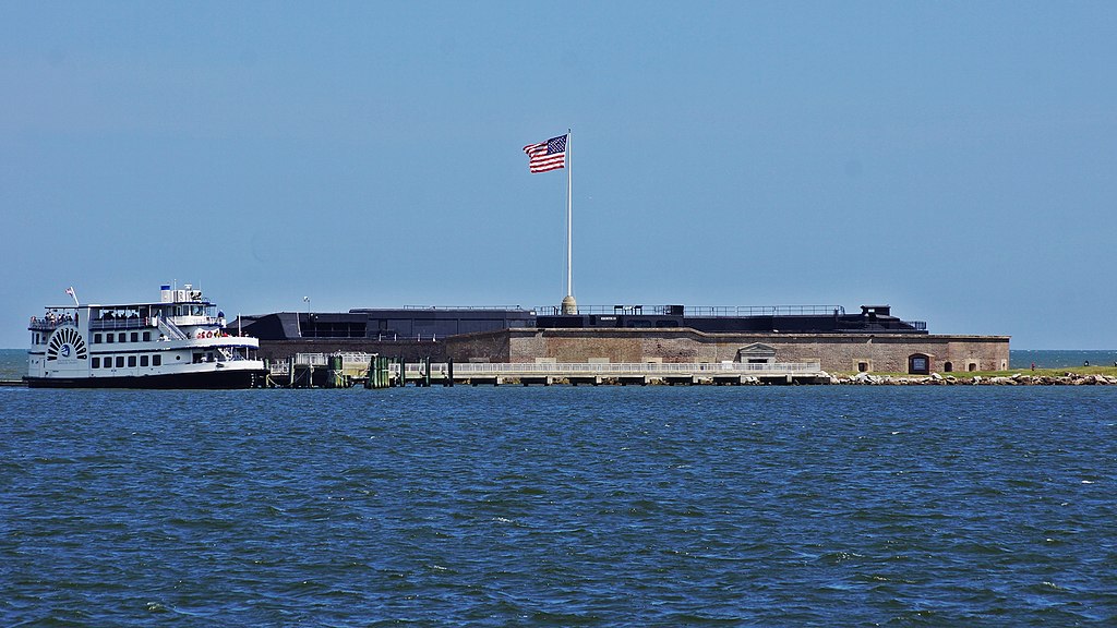
English: Construction of the South Carolina Fort Sumter National Monument on an island at the mouth of the Charleston harbor, began in 1829, and was still unfinished when the Civil War began in 1861. Seventy thousand tons of granite were dumped on a sandbar to build up the ground the fort stands on. The design, with five, 50 foot tall walls about five feet thick was built to house 135 guns and more than 600 soldiers. After the 1865 bombardment that led to the Confederate surrender, it was never rebuilt despite considerations during the Spanish American War. |
Date | |
Source | Own work |
Author | NealVickers |
Camera location | 32° 45′ 27.89″ N, 79° 52′ 51.16″ W | View this and other nearby images on: OpenStreetMap | 32.757747; -79.880878 |
---|
Licensing
[edit]- You are free:
- to share – to copy, distribute and transmit the work
- to remix – to adapt the work
- Under the following conditions:
- attribution – You must give appropriate credit, provide a link to the license, and indicate if changes were made. You may do so in any reasonable manner, but not in any way that suggests the licensor endorses you or your use.
- share alike – If you remix, transform, or build upon the material, you must distribute your contributions under the same or compatible license as the original.
This image was uploaded as part of Wiki Loves Monuments 2018.
Afrikaans ∙ Alemannisch ∙ العربية ∙ جازايرية ∙ azərbaycanca ∙ Bikol Central ∙ беларуская ∙ беларуская (тарашкевіца) ∙ български ∙ বাংলা ∙ brezhoneg ∙ bosanski ∙ català ∙ čeština ∙ Cymraeg ∙ dansk ∙ Deutsch ∙ Zazaki ∙ Ελληνικά ∙ English ∙ Esperanto ∙ español ∙ eesti ∙ euskara ∙ فارسی ∙ suomi ∙ français ∙ Frysk ∙ Gaeilge ∙ galego ∙ עברית ∙ हिन्दी ∙ hrvatski ∙ magyar ∙ հայերեն ∙ Bahasa Indonesia ∙ Ido ∙ italiano ∙ 日本語 ∙ ქართული ∙ 한국어 ∙ кыргызча ∙ Lëtzebuergesch ∙ latviešu ∙ Malagasy ∙ македонски ∙ മലയാളം ∙ Bahasa Melayu ∙ Malti ∙ norsk bokmål ∙ नेपाली ∙ Nederlands ∙ norsk nynorsk ∙ norsk ∙ polski ∙ português ∙ português do Brasil ∙ română ∙ русский ∙ sicilianu ∙ davvisámegiella ∙ slovenčina ∙ slovenščina ∙ shqip ∙ српски / srpski ∙ svenska ∙ ไทย ∙ Tagalog ∙ Türkçe ∙ українська ∙ اردو ∙ oʻzbekcha / ўзбекча ∙ Yorùbá ∙ 中文 ∙ 中文(中国大陆) ∙ 中文(简体) ∙ 中文(繁體) ∙ 中文(香港) ∙ 中文(臺灣) ∙ +/− |
File history
Click on a date/time to view the file as it appeared at that time.
Date/Time | Thumbnail | Dimensions | User | Comment | |
---|---|---|---|---|---|
current | 02:03, 24 September 2018 | 3,008 × 1,692 (2.92 MB) | NealVickers (talk | contribs) | User created page with UploadWizard |
You cannot overwrite this file.
File usage on Commons
There are no pages that use this file.
Metadata
This file contains additional information such as Exif metadata which may have been added by the digital camera, scanner, or software program used to create or digitize it. If the file has been modified from its original state, some details such as the timestamp may not fully reflect those of the original file. The timestamp is only as accurate as the clock in the camera, and it may be completely wrong.
Camera manufacturer | SONY |
---|---|
Camera model | SLT-A77V |
Exposure time | 1/320 sec (0.003125) |
F-number | f/10 |
ISO speed rating | 100 |
Date and time of data generation | 15:17, 13 July 2016 |
Lens focal length | 135 mm |
Latitude | 32° 45′ 27.89″ N |
Longitude | 79° 52′ 51.16″ W |
Altitude | 6.758 meters above sea level |
Horizontal resolution | 350 dpi |
Vertical resolution | 350 dpi |
Software used | PhotoScape |
File change date and time | 15:17, 13 July 2016 |
Y and C positioning | Co-sited |
Exposure Program | Normal program |
Exif version | 2.3 |
Date and time of digitizing | 15:17, 13 July 2016 |
Meaning of each component |
|
Image compression mode | 2 |
APEX brightness | 10.4703125 |
APEX exposure bias | 0 |
Maximum land aperture | 4.96875 APEX (f/5.6) |
Metering mode | Pattern |
Light source | Unknown |
Flash | Flash did not fire, auto mode |
Supported Flashpix version | 1 |
Color space | sRGB |
File source | Digital still camera |
Scene type | A directly photographed image |
Custom image processing | Normal process |
Exposure mode | Auto exposure |
White balance | Auto white balance |
Focal length in 35 mm film | 202 mm |
Scene capture type | Standard |
Contrast | Normal |
Saturation | Normal |
Sharpness | Normal |
GPS time (atomic clock) | 19:17 |
Receiver status | Measurement in progress |
Measurement mode | 3-dimensional measurement |
Measurement precision | Poor (1.3197) |
Speed unit | Kilometers per hour |
Speed of GPS receiver | 15.74 |
Reference for direction of movement | True direction |
Direction of movement | 284.28 |
Geodetic survey data used | WGS-84 |
GPS date | 13 July 2016 |
GPS differential correction | 0 |
GPS tag version | 2.3.0.0 |
Structured data
Items portrayed in this file
depicts
13 July 2016
32°45'27.889"N, 79°52'51.161"W
100
0.003125 second
10
135 millimetre
- Files with coordinates missing SDC location of creation
- CC-BY-SA-4.0
- Self-published work
- Images from Wiki Loves Monuments 2018
- Images from Wiki Loves Monuments 2018 in the United States
- Images from Wiki Loves Monuments 2018 in the United States missing state categorization
- Images from Wiki Loves Monuments missing SDC depicts
- Images from Wiki Loves Monuments missing SDC location of creation
- Wiki Loves Monuments 2018 in the United States unreviewed
- Uploaded via Campaign:wlm-us-other
- United States photographs taken on 2016-07-13