File:Frozen bog - geograph.org.uk - 1725525.jpg
Jump to navigation
Jump to search

Size of this preview: 800 × 600 pixels. Other resolutions: 320 × 240 pixels | 640 × 480 pixels | 1,024 × 768 pixels.
Original file (1,024 × 768 pixels, file size: 736 KB, MIME type: image/jpeg)
Captions
Captions
Add a one-line explanation of what this file represents
Summary
[edit]
| Description |
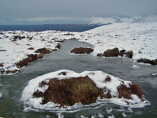
English: Frozen bog This is on the boggy summit ridge of the Waternish peninsula. After an unusually cold February, much of the surface water is frozen. I discovered that water remains unfrozen under the blanket of snow and moss on the moorland... In this picture, the line of black dots in the water beyond the hill are the Ascrib islands, and the land beyond is the tip of the Trotterish peninsula. |
| Date | |
| Source | From geograph.org.uk |
| Author | Richard Dorrell |
| Attribution (required by the license) | Richard Dorrell / Frozen bog / |
| Camera location | | View this and other nearby images on: OpenStreetMap |
|---|
_heading:67.00&language=en)
| Object location | | View this and other nearby images on: OpenStreetMap |
|---|
_heading:67.00&language=en)
Licensing
[edit]

|
This image was taken from the Geograph project collection. See this photograph's page on the Geograph website for the photographer's contact details. The copyright on this image is owned by Richard Dorrell and is licensed for reuse under the Creative Commons Attribution-ShareAlike 2.0 license.
|
This file is licensed under the Creative Commons Attribution-Share Alike 2.0 Generic license.
Attribution: Richard Dorrell
- You are free:
- to share – to copy, distribute and transmit the work
- to remix – to adapt the work
- Under the following conditions:
- attribution – You must give appropriate credit, provide a link to the license, and indicate if changes were made. You may do so in any reasonable manner, but not in any way that suggests the licensor endorses you or your use.
- share alike – If you remix, transform, or build upon the material, you must distribute your contributions under the same or compatible license as the original.
File history
Click on a date/time to view the file as it appeared at that time.
| Date/Time | Thumbnail | Dimensions | User | Comment | |
|---|---|---|---|---|---|
| current | 11:45, 5 March 2011 | | 1,024 × 768 (736 KB) | GeographBot (talk | contribs) | == {{int:filedesc}} == {{Information |description={{en|1=Frozen bog This is on the boggy summit ridge of the Waternish peninsula. After an unusually cold February, much of the surface water is frozen. I discovered that water remains unfrozen under the bla |
You cannot overwrite this file.
File usage on Commons
There are no pages that use this file.