File:FresnilloMap.jpg
Jump to navigation
Jump to search

Size of this preview: 582 × 599 pixels. Other resolutions: 233 × 240 pixels | 466 × 480 pixels | 971 × 1,000 pixels.
Original file (971 × 1,000 pixels, file size: 73 KB, MIME type: image/jpeg)
Captions
Captions
Add a one-line explanation of what this file represents
Summary
[edit]| Description |
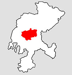
English: Map of location of Fresnillo within Zacatecas state |
| Date | 21 July 2006 (original upload date) |
| Source | Transferred from en.wikipedia to Commons. |
| Author | Arturoramos at English Wikipedia |


Licensing
[edit]
| This work has been released into the public domain by its author, Arturoramos at English Wikipedia. This applies worldwide. In some countries this may not be legally possible; if so: Arturoramos grants anyone the right to use this work for any purpose, without any conditions, unless such conditions are required by law. |
Original upload log
[edit]
The original description page was here. All following user names refer to en.wikipedia.
- 2006-07-21 23:21 Arturoramos 971×1000× (74909 bytes) Map of location of Fresnillo within Zacatecas state
File history
Click on a date/time to view the file as it appeared at that time.
| Date/Time | Thumbnail | Dimensions | User | Comment | |
|---|---|---|---|---|---|
| current | 02:36, 10 September 2012 | | 971 × 1,000 (73 KB) | OgreBot (talk | contribs) | (BOT): Uploading old version of file from en.wikipedia; originally uploaded on 2006-07-21 23:21:41 by Arturoramos |
| 23:36, 24 September 2006 |  | 240 × 247 (7 KB) | Befree~commonswiki (talk | contribs) |
You cannot overwrite this file.
File usage on Commons
The following page uses this file:
File usage on other wikis
The following other wikis use this file:
- Usage on ca.wikipedia.org
- Usage on es.wikipedia.org
- Usage on eu.wikipedia.org
- Usage on www.wikidata.org