File:Fresh Snow in the Andes (MODIS 2022-07-03).jpg

Original file (4,536 × 3,525 pixels, file size: 2.28 MB, MIME type: image/jpeg)
Captions
Captions
Summary
[edit].jpg&action=edit§ion=1)
| Description |
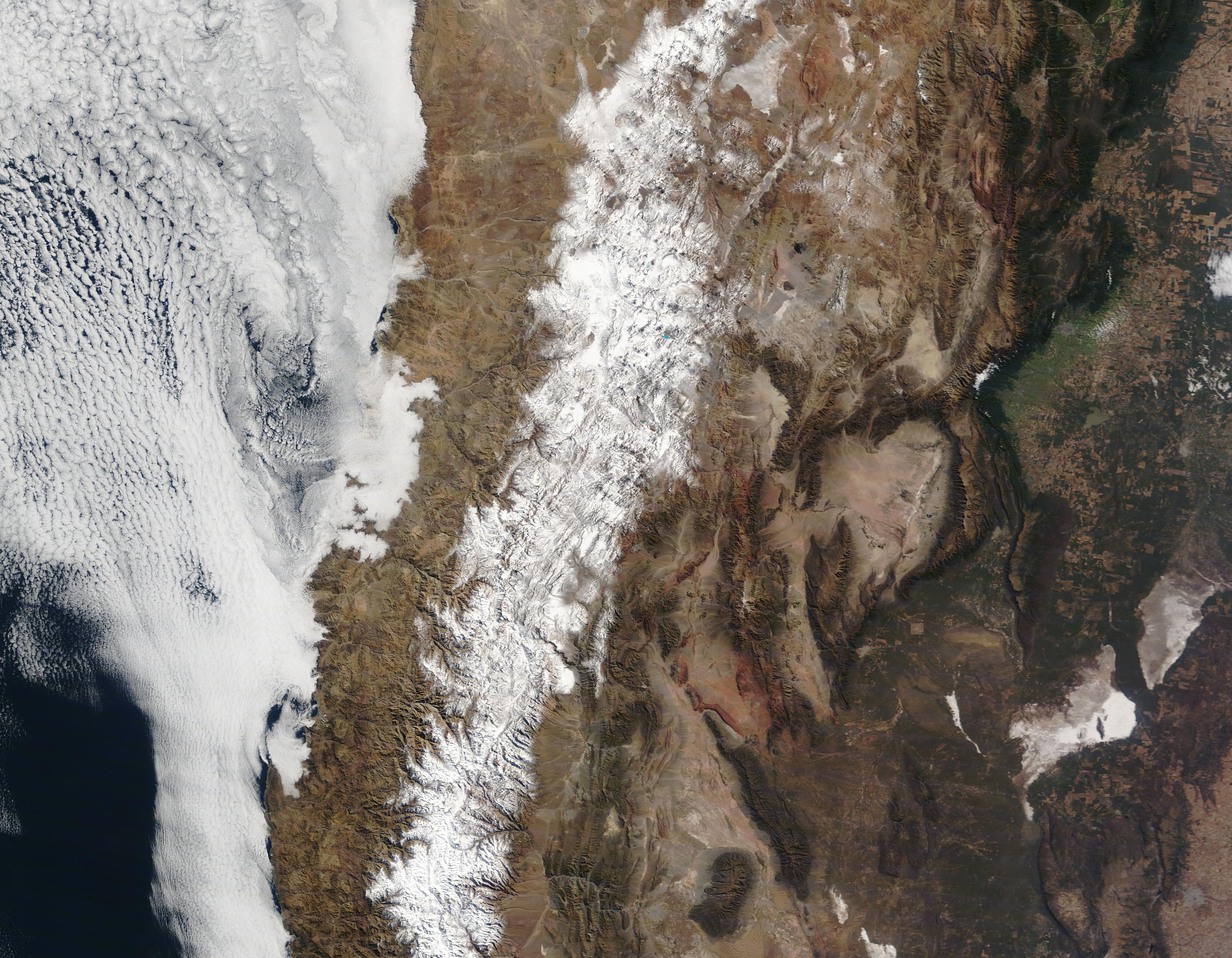
English: On June 25-27, 2022, an early winter storm brought a layer of fresh snow to the central Andes Mountains.
On June 30, three days after the skies cleared, the Moderate Resolution Imaging Spectroradiometer (MODIS) on board NASA’s Terra satellite acquired a true-color image showing a bright white blanket of snow atop the high elevations straddling both Chile (west) and Argentina (east). A gorgeous bank of marine stratocumulus cloud covered the Pacific Ocean while low cloud (fog) crept over part of Chile’s coastal plain. According to a report published on June 30 by Ski Portillo, a ski resort located near the bottom of the image, 150 cm (59 in) of snow had fallen this season. Ski Portillo opened on June 16. The Andes—the longest series of mountain ranges the world—span about 7,242 kilometers (4,500 miles) and runs through seven countries. The area captured in the image extends about 870 km (540 mi) from north to south. The snowpack that accumulates atop this extraordinary mountain chain each winter is extremely important for many reasons, including the fact that it provides the primary source of water for communities at lower altitudes. In both Chile and Argentina, springtime and summertime meltwater fill the streams that cascade off the mountains, filling reservoirs used for drinking water, power generation, and agriculture. In the central Andes, the winter snowfall is so generous that a light blanket of snow lingers most of the summer. This summer snowcover plays another important role: protecting glaciers. Fresh snow is highly reflective, preventing underlying glacial ice from absorbing the Sun’s energy, warming up, and melting. During this past summer, the snow across most of the mountaintops melted early, the result of a dry winter and a January 2022 heatwave that sent temperatures soaring to 40°C (104°F) in some locations, creating conditions ripe for rapid glacial melting. On June 14, 2022, NASA’s Earth Observatory published an Image of the Day that discussed the January 2022 heatwave and the impact on the glaciers of the Andes. Entitled “Losing a Layer of Protection”, that story can be found by clicking here. |
||
| Date | Taken on 30 June 2022 | ||
| Source |
Fresh Snow in the Andes (direct link)
|
||
| Author | MODIS Land Rapid Response Team, NASA GSFC |
| This media is a product of the Terra mission Credit and attribution belongs to the mission team, if not already specified in the "author" row |
Licensing
[edit].jpg&action=edit§ion=2)
| This file is in the public domain in the United States because it was solely created by NASA. NASA copyright policy states that "NASA material is not protected by copyright unless noted". (See Template:PD-USGov, NASA copyright policy page or JPL Image Use Policy.) | ||
 |
Warnings:
|
File history
Click on a date/time to view the file as it appeared at that time.
| Date/Time | Thumbnail | Dimensions | User | Comment | |
|---|---|---|---|---|---|
| current | 21:58, 9 January 2024 | | 4,536 × 3,525 (2.28 MB) | OptimusPrimeBot (talk | contribs) | #Spacemedia - Upload of http://modis.gsfc.nasa.gov/gallery/images/image07032022_250m.jpg via Commons:Spacemedia |
You cannot overwrite this file.
File usage on Commons
There are no pages that use this file.
.jpg&oldid=909384488)