File:Fraser Island southwest Topo Map 1942.jpg
Jump to navigation
Jump to search
Size of this preview: 800 × 549 pixels. Other resolutions: 320 × 220 pixels | 640 × 439 pixels | 1,024 × 703 pixels | 1,280 × 879 pixels | 2,560 × 1,757 pixels | 5,000 × 3,432 pixels.
Original file (5,000 × 3,432 pixels, file size: 10.89 MB, MIME type: image/jpeg)
Captions
Captions
Add a one-line explanation of what this file represents
Summary
[edit]
| Description |
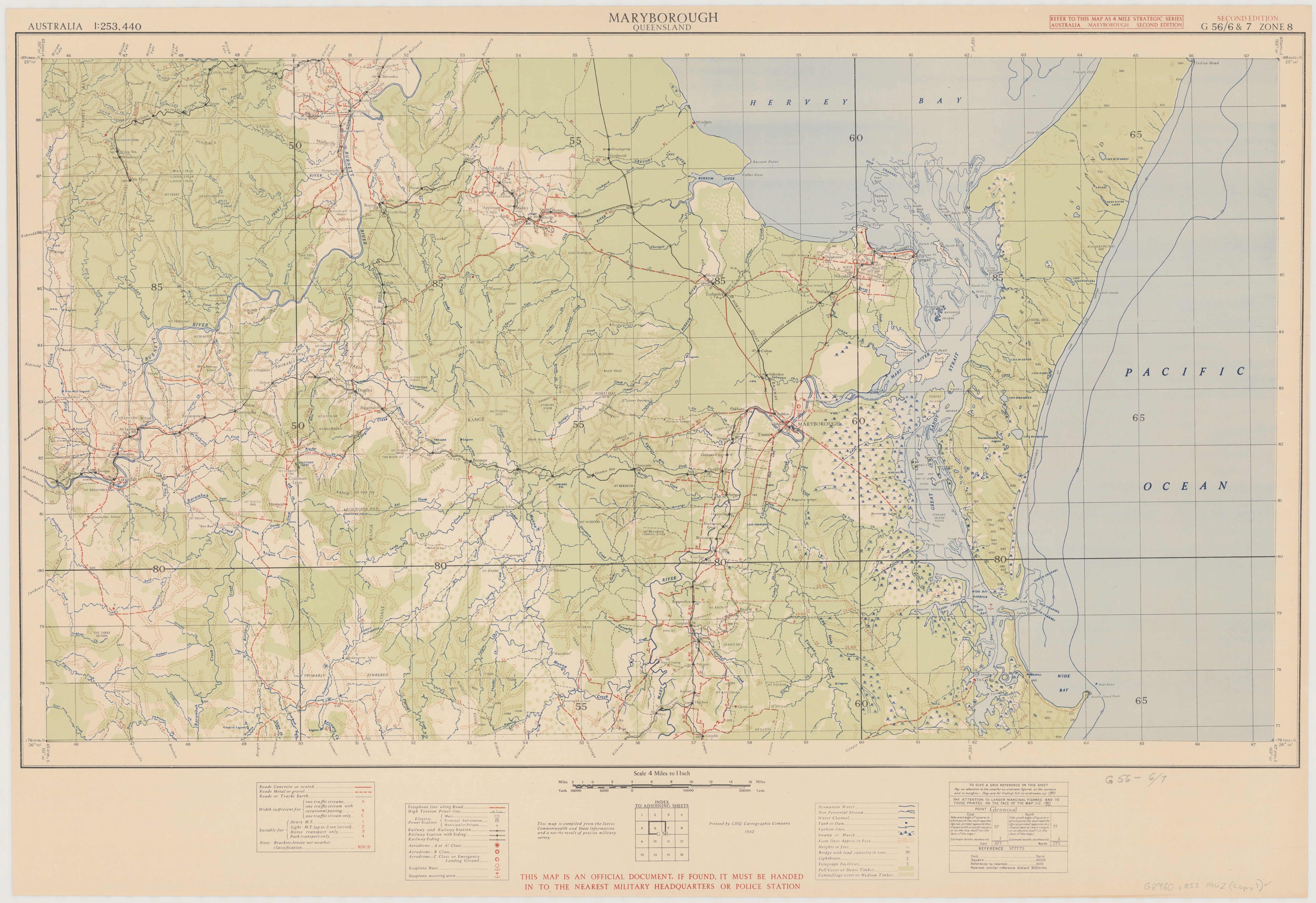
Deutsch: Topographic map sheet Maryborough, Queensland, scale 1:253,440, G 56/6 & 7 zone 8., E 151⁰30'--E 153⁰30'/S 25⁰00'--S 26⁰00', original size 47 x 82 cm., on sheet 58 x 84 cm. |
| Date | |
| Source | https://nla.gov.au/nla.obj-234104685/view |
| Author | G.H.Q. Cartographic Company |
Licensing
[edit]
| This work has been released into the public domain by its author, Out of copyright according to Copyright Information (PDF) attached to map download from https://nla.gov.au/nla.obj-234104685/view. This applies worldwide. In some countries this may not be legally possible; if so: 'Out of copyright according to Copyright Information (PDF) attached to map download from https://nla.gov.au/nla.obj-234104685/view grants anyone the right to use this work for any purpose, without any conditions, unless such conditions are required by law.
|
- Out of copyright according to Copyright Information (PDF) attached to map download from https://nla.gov.au/nla.obj-234104685/view
File history
Click on a date/time to view the file as it appeared at that time.
| Date/Time | Thumbnail | Dimensions | User | Comment | |
|---|---|---|---|---|---|
| current | 10:28, 18 April 2018 | | 5,000 × 3,432 (10.89 MB) | Ratzer (talk | contribs) | User created page with UploadWizard |
You cannot overwrite this file.
File usage on Commons
The following page uses this file:
File usage on other wikis
The following other wikis use this file:
- Usage on de.wikipedia.org
- Usage on en.wikipedia.org
- Usage on www.wikidata.org