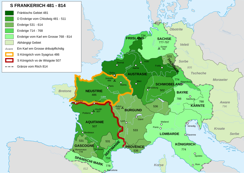
File:Frankish Empire 481 to 814-als.svg
From Wikimedia Commons, the free media repository
(Redirected from File:Frankish Empire 481 to 814-en als.svg)

Size of this PNG preview of this SVG file: 800 × 566 pixels. Other resolutions: 320 × 226 pixels | 640 × 453 pixels | 1,024 × 724 pixels | 1,280 × 905 pixels | 2,560 × 1,810 pixels | 1,735 × 1,227 pixels.
Original file (SVG file, nominally 1,735 × 1,227 pixels, file size: 331 KB)
File information
Structured data
Captions
Captions
Add a one-line explanation of what this file represents
| DescriptionFrankish Empire 481 to 814-als.svg |
[edit] Afrikaans: Die veranderende strekking van die Frankiese Ryk van 481 tot 814. Alemannisch: S Frankeriich vo 481 bis 814. Bahasa Indonesia: Peta kebangkitan Kekaisaran Franka, dari tahun 481 hingga 814. Català: Mapa de l'expansió de l'Imperi Franc, de 481 a 814. Deutsch: Karte der Ausdehnung des Fränkischen Reichs 481 bis 814. English: Map of the rise of Frankish Empire, from 481 to 814. Español: Mapa de la expansión del Imperio Franco, entre 481 y 814. Euskara: Frankoen Inperioaren hedapenaren mapa, 481-814 urteen bitartean. Français : Carte de l'expansion de l'empire Franc, entre 481 et 814. Italiano: Carta dell'espansione dell'impero dei Franchi tra il 481 e il 814. Magyar: Frank Birodalom 481-814 Nederlands: Kaart van de opkomst van het Frankische Rijk, van 481 tot 814. Polski: Mapa rozwoju Imperium Franków w latach 481-814 Português: Mapa da expansão do Império Franco, entre 481 e 814. Română: Harta ascensiunii Imperiului franc, 481-814. Svenska: Karantanien i det frankiska riket (år 788 - 843). Ελληνικά: Η Φραγκική Αυτοκρατορία 481-814 Македонски: Карта на подемот на Франкското царство, од 481 до 814 г. Русский: Карта расширения империи франков, между 481 и 814. Українська: Карта розширення імперії Франків в період 481-814 рр. 日本語: カロリング朝の版図。 中文: 墨洛温王朝到加洛林王朝(481—814)的法兰克王国。 العربية : إمبراطوريَّة الفرنجة ما بين عاميّ 481 و814م |
|||
| Source |
|
|||
| Author | Sémhur | |||
| Permission (Reusing this file) |
GFDL | |||
| Other versions |
[edit]
|

|
Permission is granted to copy, distribute and/or modify this document under the terms of the GNU Free Documentation License, Version 1.2 or any later version published by the Free Software Foundation; with no Invariant Sections, no Front-Cover Texts, and no Back-Cover Texts. A copy of the license is included in the section entitled GNU Free Documentation License.http://www.gnu.org/copyleft/fdl.htmlGFDLGNU Free Documentation Licensetruetrue |
| This file is licensed under the Creative Commons Attribution-Share Alike 3.0 Unported license. | ||
| ||
| This licensing tag was added to this file as part of the GFDL licensing update.http://creativecommons.org/licenses/by-sa/3.0/CC BY-SA 3.0Creative Commons Attribution-Share Alike 3.0truetrue |
File history
Click on a date/time to view the file as it appeared at that time.
| Date/Time | Thumbnail | Dimensions | User | Comment | |
|---|---|---|---|---|---|
| current | 15:51, 28 February 2009 |  | 1,735 × 1,227 (331 KB) | Andi d (talk | contribs) | {{Information |Description=S Frankeriich vo 481 bis 814 |Source=from Image:Frankish empire.jpg, itself from en:Image:Frankish power 481 814.jpg, from the Historical Atlas by William R. Shepherd (Shepherd, William. Historical Atlas. New York: Henry Holt an |
You cannot overwrite this file.
File usage on Commons
The following 2 pages use this file:
- File:Frankish Empire 481 to 814-en als.svg (file redirect)
- Category:Frankish people
File usage on other wikis
The following other wikis use this file:
- Usage on als.wikipedia.org
- Usage on ar.wikipedia.org
- Usage on ast.wikipedia.org
- Usage on ia.wikipedia.org
- Usage on www.wikidata.org
Metadata
This file contains additional information such as Exif metadata which may have been added by the digital camera, scanner, or software program used to create or digitize it. If the file has been modified from its original state, some details such as the timestamp may not fully reflect those of the original file. The timestamp is only as accurate as the clock in the camera, and it may be completely wrong.
| Width | 1735 |
|---|---|
| Height | 1226.7548 |
