File:Francuskie i brytyjskie forty 1753 1758.jpg
Jump to navigation
Jump to search
No higher resolution available.
Francuskie_i_brytyjskie_forty_1753_1758.jpg (457 × 591 pixels, file size: 179 KB, MIME type: image/jpeg)
Captions
Captions
Add a one-line explanation of what this file represents
| Description |
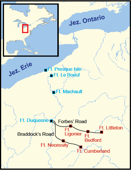
Polski: Mapa pokazuje pozycje francuskich (niebieski) i brytyjskich (czerwony) fortów w latach 1753-1758, oraz przybliżoną trasę Drogi Braddocka (Braddock's Road) i Forbesa (Forbes' Road). |
| Date | (UTC) |
| Source | |
| Author |
|
| This is a retouched picture, which means that it has been digitally altered from its original version. Modifications: Polish labels, minor graphical edits. The original can be viewed here: French British Forts 1753 1758.png:
|
I, the copyright holder of this work, hereby publish it under the following licenses:
This image is in the public domain because it came from the site https://www.demis.nl/products/web-map-server/examples/ and was released by the copyright holder. Permission is granted to copy, distribute and/or modify this map since it is based on free of copyright images from: www.demis.nl. See also approval email on de.wp and its clarification.
|
| This work has been released into the public domain by its copyright holder, www.demis.nl. This applies worldwide. In some countries this may not be legally possible; if so: www.demis.nl grants anyone the right to use this work for any purpose, without any conditions, unless such conditions are required by law.
|
| I, the copyright holder of this work, release this work into the public domain. This applies worldwide. In some countries this may not be legally possible; if so: I grant anyone the right to use this work for any purpose, without any conditions, unless such conditions are required by law. |
You may select the license of your choice.
Original upload log
[edit]
This image is a derivative work of the following images:
- File:French_British_Forts_1753_1758.png licensed with PD-Demis, PD-self
- 2007-01-07T21:46:11Z Tomcool 328x423 (32279 Bytes)
- 2007-01-07T21:31:23Z Tomcool 328x423 (32315 Bytes)
- 2007-01-07T21:27:02Z Tomcool 328x423 (32225 Bytes)
- 2007-01-02T23:27:31Z Tomcool 328x423 (31772 Bytes)
- 2006-12-27T02:24:25Z Tomcool 328x423 (29345 Bytes)
- 2006-12-27T02:22:05Z Tomcool 328x423 (20473 Bytes)
- 2006-12-27T02:07:43Z Tomcool 328x423 (29006 Bytes)
- 2006-12-27T01:57:41Z Tomcool 328x423 (24780 Bytes)
- 2006-12-27T01:10:18Z Tomcool 715x762 (72748 Bytes)
- 2006-03-25T16:03:13Z Tomcool 813x549 (736319 Bytes) ==Description== French and British forts built in the Ohio Country from 1753 to 1758. Includes French Forts (New France): Fort Presque Isle, Fort Le Boeuf, Fort Machault and Fort Duquesne. Also, Britsh Forts: Fort Littleton
Uploaded with derivativeFX
File history
Click on a date/time to view the file as it appeared at that time.
| Date/Time | Thumbnail | Dimensions | User | Comment | |
|---|---|---|---|---|---|
| current | 14:13, 14 May 2011 | | 457 × 591 (179 KB) | Hoodinski (talk | contribs) | {{Information |Description={{en|1=French and British forts built in the Ohio Country from 1753 to 1758. Includes French Forts (New France): Fort Presque Isle, Fort Le Boeuf, Fort Machault and Fort Duquesne. Also, Britsh Forts: Fort Littleton, Fort Bedfo |
You cannot overwrite this file.
File usage on Commons
There are no pages that use this file.
File usage on other wikis
The following other wikis use this file:
- Usage on fr.wikipedia.org
- Usage on pl.wikipedia.org