File:France départementale.svg

Original file (SVG file, nominally 2,000 × 1,898 pixels, file size: 1.87 MB)
Captions
Captions
Summary
[edit]| Description |
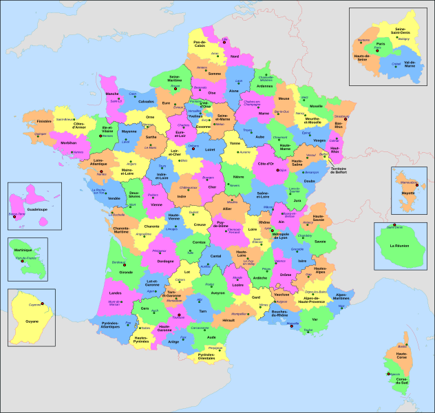
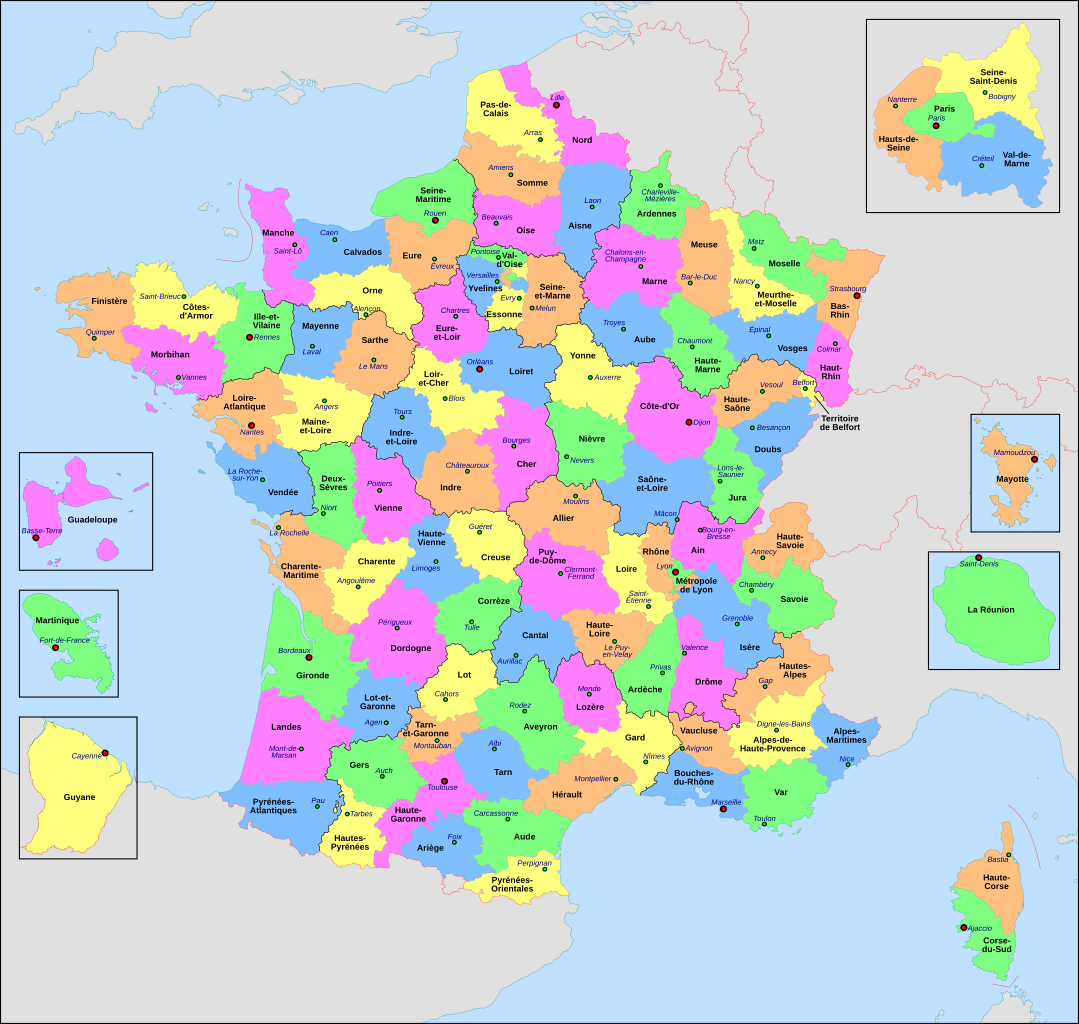
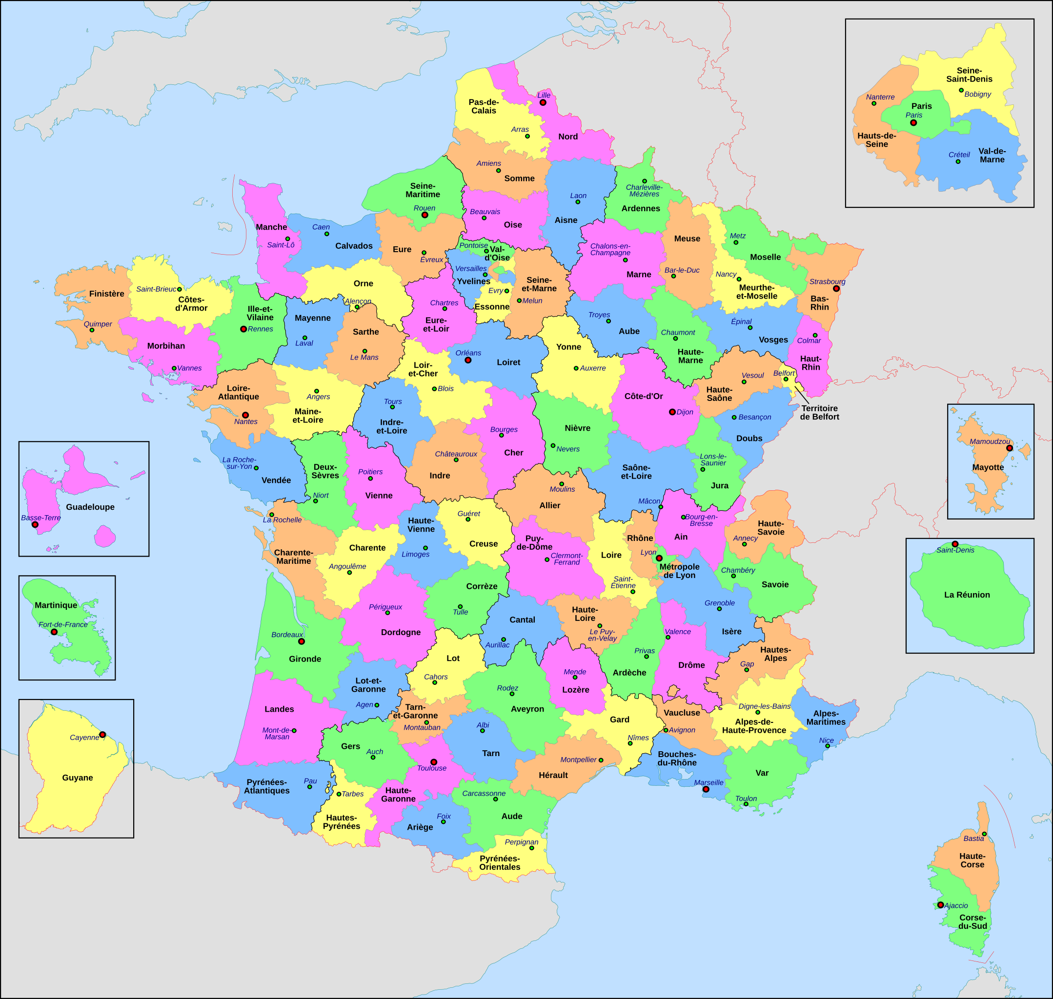
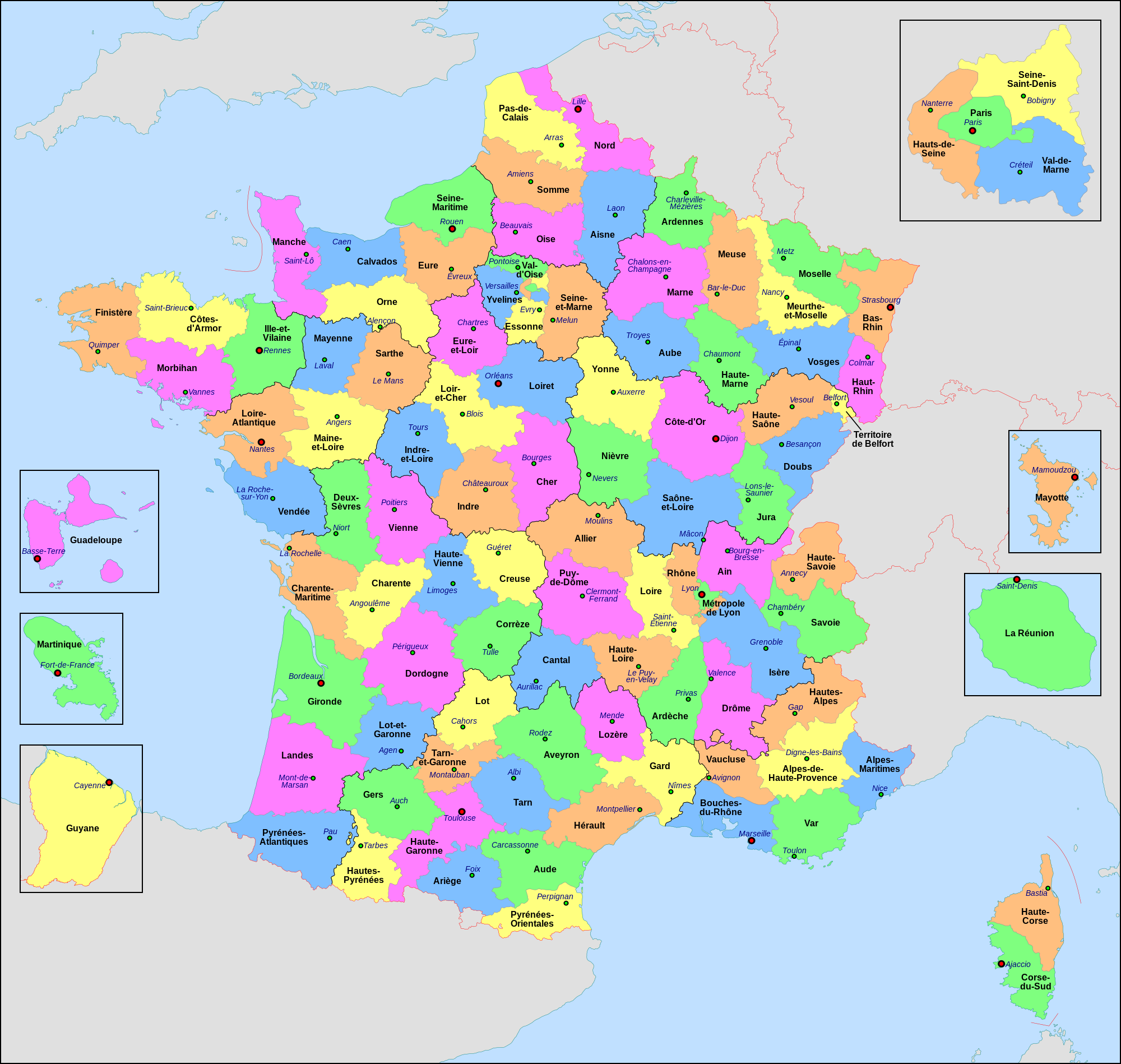
Français : Carte administrative de la France, créée sous Inkscape 0.47 à partir de plusieurs cartes (notamment celle-ci) créées par Sting.
Le fichier comporte vingt-quatre calques : Cadre, Chef-lieux de région, Villes, Chef-lieux de département, Numéros de département, Noms des régions, Nom des départements, **Encarts Départements d'Outre-Mer, **Encart Paris-Petite-Couronne, Coordonnées, Échelle et Mini-carte, Frontières internationales, Côtes, Limites régionales, Limites départementales, Lacs, Fleuves, *Régions métropolitaines, *Départements métropolitains, Terres françaises, Terres étrangères, Mers et océans, Échelle altimétrique, Topographie.
English: Administrative map of France, created under Inkscape 0.47 from several of the maps (especially this one) created by Sting.
The file consists of twenty-four layers: Frame, Administrative Centres of Regions, Towns, Administrative Centres of Departments, Numbers of Departments, Names of Regions, Names of Departments, **Overseas Departements Insets, **Paris Conurbation Inset, Coordinates, Scale and Mini-map, International boundaries, Coasts, Regional boundaries, Departmental boundaries, Lakes, Rivers, *Metropolitan Regions, *Metropolitan Departments, French lands, Foreign lands, Seas and Oceans, Altimetric Scale, Topography.
|
| Date | |
| Source | Own work |
| Author | Nilstilar |
| Other versions |
|
| SVG development |


Licensing
[edit]
- You are free:
- to share – to copy, distribute and transmit the work
- to remix – to adapt the work
- Under the following conditions:
- attribution – You must give appropriate credit, provide a link to the license, and indicate if changes were made. You may do so in any reasonable manner, but not in any way that suggests the licensor endorses you or your use.
- share alike – If you remix, transform, or build upon the material, you must distribute your contributions under the same or compatible license as the original.
This image is used on a user page of a Wikimedia user and is stored on Commons according to the rules set out in Commons:Project scope#File in use on Commons only: the uploading of small numbers of images (e.g. of yourself) for use on a personal Commons user page is allowed or Commons:Project scope#File in use in another Wikimedia project: the uploading of small numbers of images (e.g. of yourself) for use on a personal user page of another project is allowed as long as that user is or was an active participant on that project.
If the image ceases to be used it may be eligible for deletion as it may have no educational purpose.
File history
Click on a date/time to view the file as it appeared at that time.
| Date/Time | Thumbnail | Dimensions | User | Comment | |
|---|---|---|---|---|---|
| current | 20:29, 22 June 2022 | | 2,000 × 1,898 (1.87 MB) | OpesMentis (talk | contribs) | Added hyphens on departments' names and towns' names and fixed "Réunion" to "La Réunion" |
| 18:10, 9 November 2021 |  | 2,000 × 1,898 (1.87 MB) | Puck04 (talk | contribs) | fixed SVG code (was "W3C-invalid") + cleanup using text editor; contains some invisible pathes | |
| 00:40, 1 May 2020 |  | 2,000 × 1,898 (4.7 MB) | ChrisPtDe (talk | contribs) | File uploaded using svgtranslate tool (https://tools.wmflabs.org/svgtranslate/). Added translation for frp. | |
| 22:17, 28 April 2020 |  | 2,000 × 1,898 (4.7 MB) | ChrisPtDe (talk | contribs) | File uploaded using svgtranslate tool (https://tools.wmflabs.org/svgtranslate/). Added translation for frp. | |
| 22:56, 25 April 2020 |  | 2,000 × 1,898 (4.68 MB) | ChrisPtDe (talk | contribs) | File uploaded using svgtranslate tool (https://tools.wmflabs.org/svgtranslate/). Added translation for frp. | |
| 14:13, 4 November 2018 |  | 2,000 × 1,898 (4.55 MB) | Nilstilar (talk | contribs) | Corse "réunifiée" pose problème | |
| 12:05, 4 November 2018 |  | 2,000 × 1,898 (4.54 MB) | Nilstilar (talk | contribs) | Corse "réunifiée" (collectivité territoriale unique — département & région — au 1/1/2018) | |
| 13:01, 15 October 2018 |  | 2,000 × 1,898 (4.55 MB) | Nilstilar (talk | contribs) | Reverted to version as of 18:52, 10 May 2017 (UTC) | |
| 22:30, 28 December 2017 |  | 2,000 × 1,898 (2.24 MB) | Ras67 (talk | contribs) | frame removed, all invisible data stripped | |
| 18:52, 10 May 2017 |  | 2,000 × 1,898 (4.55 MB) | Nilstilar (talk | contribs) | Rétablissement des limites régionales (au 01/10/2016) |
You cannot overwrite this file.
File usage on Commons
The following 7 pages use this file:
File usage on other wikis
The following other wikis use this file:
- Usage on ar.wikipedia.org
- Usage on arz.wikipedia.org
- Usage on ast.wikipedia.org
- Usage on ast.wiktionary.org
- Usage on az.wikipedia.org
- Usage on bg.wikipedia.org
- Usage on br.wikipedia.org
- Usage on ca.wikipedia.org
- Usage on cy.wikipedia.org
- Usage on el.wikipedia.org
- Usage on en.wikipedia.org
- Usage on es.wikipedia.org
- Usage on eu.wikipedia.org
- Usage on fr.wikipedia.org
- Département français
- Monument historique (France)
- Géographie de la Guadeloupe
- Économie de la Guadeloupe
- Transports en France
- Liste des ponts de Paris
- Géographie de la Drôme
- Liste des anciennes communes du Loiret
- Économie de La Réunion
- Politique dans la Haute-Vienne
- Politique dans la Creuse
- Climat des Yvelines
- Géographie du Territoire de Belfort
- Culture en Guyane
- Économie du Puy-de-Dôme
- Géographie de la Charente-Maritime
- Économie de l'Oise
- Économie de la Haute-Savoie
- Climat de l'Aveyron
- Climat du Bas-Rhin
- Climat du Haut-Rhin
- Géographie du Loiret
- Arboretum de Balaine
- Transports dans la métropole de Lyon
- Économie de la Haute-Saône
- Climat du Finistère
- Politique à La Réunion
- Géographie d'Eure-et-Loir
- Transport en Corse
- Liste des musées de Paris
View more global usage of this file.