File:Fra Mauro World Map Satellite Comparison.jpg
Jump to navigation
Jump to search

Size of this preview: 800 × 393 pixels. Other resolutions: 320 × 157 pixels | 640 × 315 pixels | 1,024 × 504 pixels | 1,991 × 979 pixels.
Original file (1,991 × 979 pixels, file size: 2.26 MB, MIME type: image/jpeg)
Captions
Captions
Add a one-line explanation of what this file represents
Summary
[edit]
| Description |
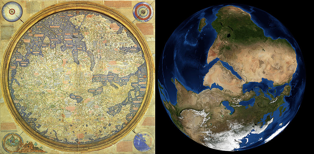
English: A comparison of the Frau Mauro World Map from AD 1450 and a satellite image of Earth, rotated to correspond to the map. The satellite image - the Blue Marble - was created using data from the MODIS instrument onboard the Terra and Aqua satellites. |
| Date | |
| Source | http://landsat.gsfc.nasa.gov/wp-content/uploads/2014/01/Fra-Mauro_Global-comparison-south.jpg |
| Author | NASA |
Licensing
[edit]
| This file is in the public domain in the United States because it was solely created by NASA. NASA copyright policy states that "NASA material is not protected by copyright unless noted". (See Template:PD-USGov, NASA copyright policy page or JPL Image Use Policy.) | ||
 |
Warnings:
|
File history
Click on a date/time to view the file as it appeared at that time.
| Date/Time | Thumbnail | Dimensions | User | Comment | |
|---|---|---|---|---|---|
| current | 05:07, 3 March 2015 | | 1,991 × 979 (2.26 MB) | Koyos (talk | contribs) | User created page with UploadWizard |
You cannot overwrite this file.
File usage on Commons
There are no pages that use this file.
File usage on other wikis
The following other wikis use this file:
- Usage on id.wikipedia.org
- Usage on lt.wikipedia.org
- Usage on sl.wikipedia.org
- Usage on su.wikipedia.org
- Usage on uk.wikipedia.org