File:Frökinds härad (Hermelin 1807).jpg
Jump to navigation
Jump to search

Size of this preview: 791 × 600 pixels. Other resolutions: 317 × 240 pixels | 633 × 480 pixels | 1,013 × 768 pixels | 1,280 × 971 pixels | 1,461 × 1,108 pixels.
Original file (1,461 × 1,108 pixels, file size: 2.3 MB, MIME type: image/jpeg)
Captions
Captions
Add a one-line explanation of what this file represents
Summary
[edit]| Description |
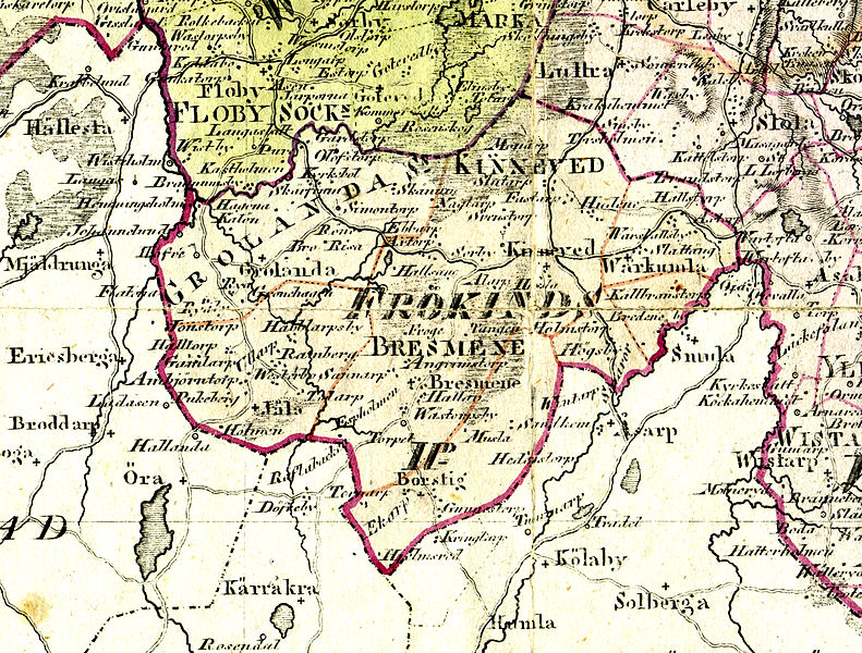
English: Frökind hundred in Skaraborg county, Västergötland, Sweden in the year 1807. Detail from the old map "Karta öfver Skaraborgs Höfdingsdöme Utgiven av Friherre S. G. Hermelin Efter Geometriska Kartor, nyaste Astronomiska Observationer och under Resor gjorda Rättelser, Författad av C. G. Forssell 1807". Scanned an adjusted by Achird 2010. In this map the parished Kinneved, Vårkumla, Brismene, and Jäla (sic!) is fully included in the Frökind hundred, and two thirds of Börstig parish (Börstig and Mussla, but not Döve), and parts of the parishes Smula and Norra Åsarp. Note that this is the only source that includes Jäla parish in Frökind hundred!
Svenska: Frökinds härad i Skaraborgs län i Västergötland i Sverige år 1807. Detalj ur den gamla kartan "Karta öfver Skaraborgs Höfdingsdöme Utgiven av Friherre S. G. Hermelin Efter Geometriska Kartor, nyaste Astronomiska Observationer och under Resor gjorda Rättelser, Författad av C. G. Forssell 1807". Skannad och justerad av Achird 2010. På denna karta ingår socknarna Kinneved, Vårkumla, Brismene och Jäla (sic!) helt i Frökinds härad, samt 2/3 av Börstigs socken (Börstig och Mussla, men inte Döve), och delar av socknarna Smula och Norra Åsarp. Notera att detta är den enda källa som inkluderar Jäla socken i Frökinds härad! Jäla socken och västra tredjedelen av Grolanda socken brukar nämligen föras till Vilske härad. Den breda röda gräns som löper över kartan är den dåvarande gränsen mellan Skaraborgs län och Älvsborgs län. |
|||||||||||||||||
| Date | ||||||||||||||||||
| Source | Own work | |||||||||||||||||
| Author |
S.G. Hermelin and C.G. Forssell / Achird |
|||||||||||||||||

.jpg&action=edit§ion=1)
Licensing
[edit].jpg&action=edit§ion=2)
|
This work is in the public domain in its country of origin and other countries and areas where the copyright term is the author's life plus 100 years or fewer. This work is in the public domain in the United States because it was published (or registered with the U.S. Copyright Office) before January 1, 1929. | |
| This file has been identified as being free of known restrictions under copyright law, including all related and neighboring rights. | |
File history
Click on a date/time to view the file as it appeared at that time.
| Date/Time | Thumbnail | Dimensions | User | Comment | |
|---|---|---|---|---|---|
| current | 15:14, 12 October 2010 | | 1,461 × 1,108 (2.3 MB) | Achird (talk | contribs) | {{Information |Description={{en|1=Frökind hundred in Västergötland, Sweden in the year 1807. Detail from the old map "Karta öfver Skaraborgs Höfdingsdöme Utgiven av Friherre S. G. Hermelin Efter Geometriska Kartor, nyaste Astronomiska Observationer |
You cannot overwrite this file.
File usage on Commons
The following page uses this file:
.jpg&oldid=705283217)