File:Foxe Basin to Cumberland Sound, Canada (MODIS 2018-09-06).jpg

Original file (3,051 × 2,800 pixels, file size: 1.31 MB, MIME type: image/jpeg)
Captions
Captions
Summary
[edit].jpg&action=edit§ion=1)
| Description |
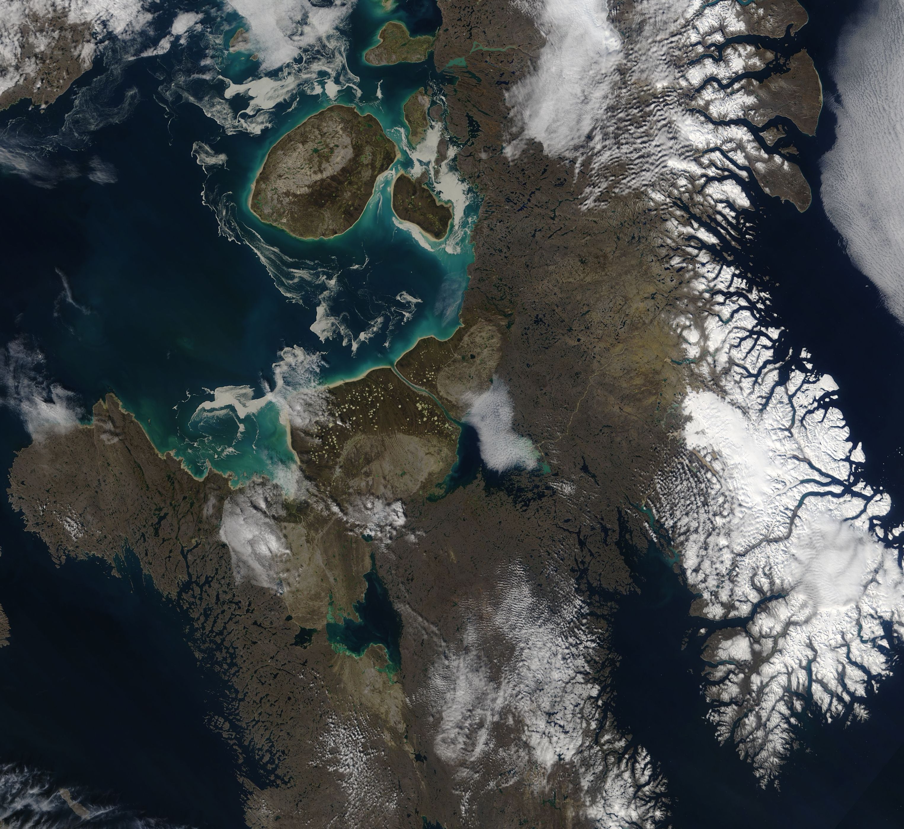
English: As the calendar marches towards the closing days of summer in the Northern Hemisphere, swirls of sea ice remain in Canada’s Foxe Basin. The Moderate Resolution Imaging Spectroradiometer (MODIS) on board NASA’s Aqua satellite acquired a true-color image of Foxe Basin and the Cumberland Sound on September 3, 2018.
Foxe Basin lies north of Hudson Bay between the Melville Peninsula (west) and Baffin Island, which remains largely covered in snow. Davis Strait sits northeast of Baffin Island, while the long Cumberland Sound, a projection of the Labrador Sea, can be seen in the southeast. Part of the Hudson Strait is visible in the southwest corner of the image. The nearly-round Prince Charles Island sits near the coast of the much larger Baffin Island, wearing a thin white ring of what appears to be fast ice (sea ice clinging to the shoreline) and, further offshore, filigrees of floating sea ice. Ice also can be seen along the eastern and southern water and shorelines, as well as some surrounding more northerly reaches of Foxe Basin. Foxe Basin typically remains ice-covered for most of each year. A ring of bright blue surrounds Prince Charles Island and much of the coastline. Duller blues and greens can be seen swirling throughout the waters of Foxe Basin. These colors are likely a combination of sediment, which often appears bright in color when it sits near the surface - especially as melting ice gently slides sediment onto the topmost layers of water near shore – and phytoplankton. Phytoplankton are microscopic plant-like organisms that live in these waters year-round and reproduce in massive colonies when conditions become right. As winter’s coating of ice melts, it brings nutrients into the cold waters while increasing sunlight and warming temperatures also encourage growth of phytoplankton – ultimately creating colonies large enough to be seen from space. Phytoplankton form the basis of the marine food web, and in the Foxe Basin they help support one of the most biologically rich and diverse areas of the Canadian Arctic. The region provides a home and breeding ground for Polar Bear, colonies of bearded seals, and the largest walrus herd in Canada. The waters are a summer home to narwhal, bowhead, and beluga whales. |
||
| Date | Taken on 3 September 2018 | ||
| Source |
Foxe Basin to Cumberland Sound, Canada (direct link)
|
||
| Author | MODIS Land Rapid Response Team, NASA GSFC |
| This media is a product of the Aqua mission Credit and attribution belongs to the mission team, if not already specified in the "author" row |
Licensing
[edit].jpg&action=edit§ion=2)
| This file is in the public domain in the United States because it was solely created by NASA. NASA copyright policy states that "NASA material is not protected by copyright unless noted". (See Template:PD-USGov, NASA copyright policy page or JPL Image Use Policy.) | ||
 |
Warnings:
|
File history
Click on a date/time to view the file as it appeared at that time.
| Date/Time | Thumbnail | Dimensions | User | Comment | |
|---|---|---|---|---|---|
| current | 01:32, 17 February 2024 | | 3,051 × 2,800 (1.31 MB) | OptimusPrimeBot (talk | contribs) | #Spacemedia - Upload of http://modis.gsfc.nasa.gov/gallery/images/image09062018_250m.jpg via Commons:Spacemedia |
You cannot overwrite this file.
File usage on Commons
There are no pages that use this file.
.jpg&oldid=852746024)