File:Fourlevel int 12252005.jpg
Jump to navigation
Jump to search
Size of this preview: 594 × 599 pixels. Other resolutions: 238 × 240 pixels | 476 × 480 pixels | 680 × 686 pixels.
Original file (680 × 686 pixels, file size: 530 KB, MIME type: image/jpeg)
Captions
Captions
Add a one-line explanation of what this file represents
Summary
[edit]
| Description |
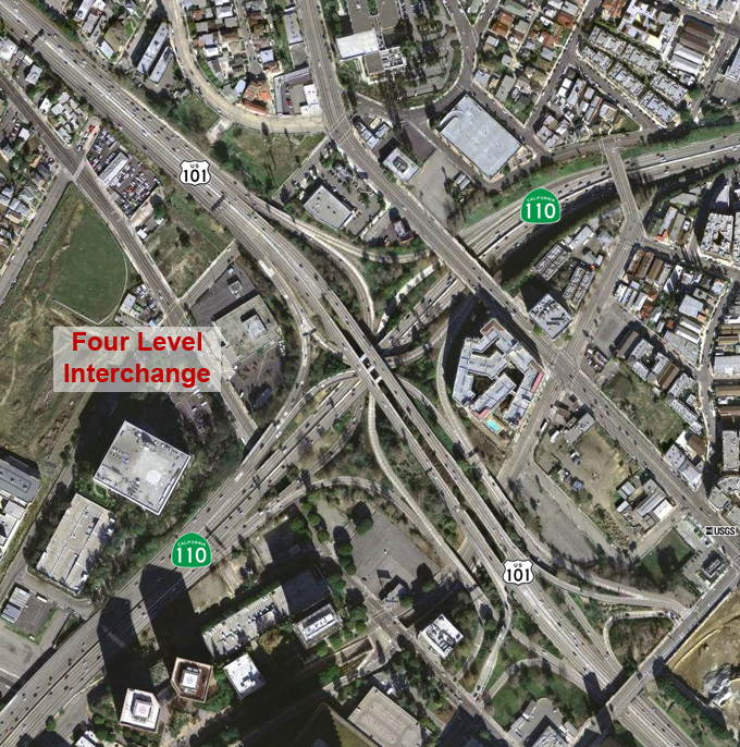
English: The Four Level Interchange. Underlying map is an aerial map obtained from the USGS
The overlying work (freeway number shields, city labels, etc.) are by me. |
| Source | |
| Author |
Licensing
[edit]
This image is in the public domain in the United States because it only contains materials that originally came from the United States Geological Survey, an agency of the United States Department of the Interior. For more information, see the official USGS copyright policy.
|
Original upload log
[edit]
The original description page was here. All following user names refer to en.wikipedia.
| Date/Time | Dimensions | User | Comment |
|---|---|---|---|
| 2005-12-26 07:37 | 680×686× (542669 bytes) | Mikeetc | The Four Level Interchange. Underlying map is an aerial map obtained from the USGS The overlying work (freeway number shields, city labels, etc.) are by me. |
File history
Click on a date/time to view the file as it appeared at that time.
| Date/Time | Thumbnail | Dimensions | User | Comment | |
|---|---|---|---|---|---|
| current | 03:46, 24 April 2017 | | 680 × 686 (530 KB) | Rschen7754 (talk | contribs) | Transferred from en.wikipedia |
You cannot overwrite this file.
File usage on Commons
There are no pages that use this file.
File usage on other wikis
The following other wikis use this file:
- Usage on en.wikipedia.org