File:Found! (51928348630).jpg

Original file (5,472 × 3,648 pixels, file size: 4.57 MB, MIME type: image/jpeg)
Captions
Captions
Summary
[edit].jpg&action=edit§ion=1)
| Description |
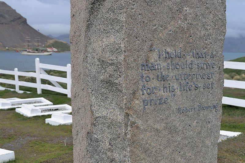
After all the miserable news of recent times, I was genuinely touched by the rediscovery of Shackleton's "Endurance", earlier this week, 100 Years after Shackleton's death. Endurance was found at a depth of 3,008 metres and approximately four miles south of the position originally recorded by the ship’s captain, Frank Worsley. I've always been a nut for (ant)arctic exploration. And Shackleton (15 February 1874 – 5 January 1922) is one of my heroes. This photograph shows the rear of Earnest Shackleton's grave at Grytviken, South Georgia. Beautiful words, wonderful peaceful place. The imagery of the wreck is fantastic: <a href="https://www.nytimes.com/2022/03/09/climate/endurance-wreck-found-shackleton.html?referringSource=articleShare" rel="noreferrer nofollow">www.nytimes.com/2022/03/09/climate/endurance-wreck-found-...</a> |
| Date | |
| Source | Found! |
| Author | Rob Oo from NL |
| Camera location | | View this and other nearby images on: OpenStreetMap |
|---|
.jpg¶ms=-54.284956_N_-036.507228_E_globe:Earth_type:camera_source:Flickr_&language=en)
Licensing
[edit].jpg&action=edit§ion=2)
- You are free:
- to share – to copy, distribute and transmit the work
- to remix – to adapt the work
- Under the following conditions:
- attribution – You must give appropriate credit, provide a link to the license, and indicate if changes were made. You may do so in any reasonable manner, but not in any way that suggests the licensor endorses you or your use.
| This image was originally posted to Flickr by Rob Oo at https://flickr.com/photos/105105658@N03/51928348630. It was reviewed on 9 March 2022 by FlickreviewR 2 and was confirmed to be licensed under the terms of the cc-by-2.0. |
File history
Click on a date/time to view the file as it appeared at that time.
| Date/Time | Thumbnail | Dimensions | User | Comment | |
|---|---|---|---|---|---|
| current | 21:39, 9 March 2022 | | 5,472 × 3,648 (4.57 MB) | BugWarp (talk | contribs) | Transferred from Flickr via #flickr2commons |
You cannot overwrite this file.
File usage on Commons
The following 2 pages use this file:
.jpg&oldid=842302048)