File:Fosse Arenberg début 1900.jpg

Original file (2,825 × 1,798 pixels, file size: 1.73 MB, MIME type: image/jpeg)
Captions
Captions
Summary
[edit]| Description |
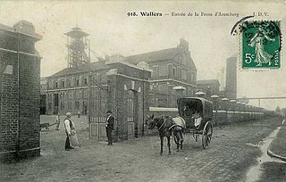
Français : La fosse Arenberg de la Compagnie des mines d'Anzin était un charbonnage du bassin minier du Nord-Pas-de-Calais constitué de trois puits (dont un double compartimenté) situé à Wallers, Nord, Nord-Pas-de-Calais, France. La fosse Arenberg est classée aux monuments historiques le 22 février 2010, le périmètre de classement et d'inscription datant de 1992 ayant été étendu. Elle est également inscrite sur la liste du patrimoine mondial de l'Unesco le 30 juin 2012 et y constitue en partie le site no 15. |
||||
| Date | circa 1900 | ||||
| Source |
Français : Carte postale ancienne |
||||
| Author | Unknown author | ||||
| Permission (Reusing this file) |
|
||||

| Object location | | View this and other nearby images on: OpenStreetMap |
|---|
File history
Click on a date/time to view the file as it appeared at that time.
| Date/Time | Thumbnail | Dimensions | User | Comment | |
|---|---|---|---|---|---|
| current | 14:25, 13 November 2011 | | 2,825 × 1,798 (1.73 MB) | Jérémy-Günther-Heinz Jähnick (talk | contribs) | Meilleure résolution. |
| 10:45, 1 October 2011 |  | 935 × 595 (90 KB) | Autrot (talk | contribs) |
You cannot overwrite this file.
File usage on Commons
There are no pages that use this file.