File:Forth Railway Bridge - geograph.org.uk - 245180.jpg
Jump to navigation
Jump to search
No higher resolution available.
Forth_Railway_Bridge_-_geograph.org.uk_-_245180.jpg (640 × 426 pixels, file size: 94 KB, MIME type: image/jpeg)
Captions
Captions
Add a one-line explanation of what this file represents
Summary
[edit]
| Description |
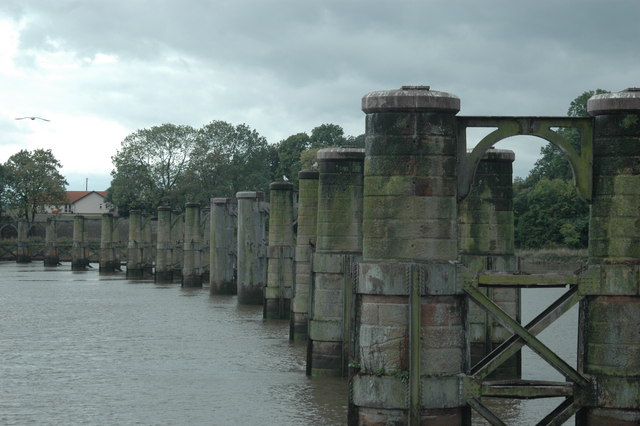
English: Forth Railway Bridge. The railway between Throsk and Alloa was authorised in 1879 as a branch from the Caledonian Railway's South Alloa branch, the CR absorbed the line in 1884 and it was closed from 6 May 1968. The photograph is from the middle of the river, we are passing through where the swing span was, and shows the southern part of the bridge. This bridge, until the opening of the Forth Bridge at Queensferry, was the most downstream bridge on the Forth. Latterly it was a somewhat rickety affair with a 10mph speed restriction and was used by a shuttle service between Larbert and Alloa operated by a 4 wheel diesel railbus although, in earlier years, there had been through Glasgow - Perth services via the Devon Valley. The bridge, by the way, is not shown on the OS 1/50000 map (!) but is on the Admiralty Charts, fortunately.
Français : Forth Railway Bridge. La construction de la voie ferrée entre Throsk et Alloa a été décidée en 1879 en tant que une branche de la section South Alloa du Caledonian Railway. Le CR a absorbé la ligne en 1884 et celle-ci fut fermée le 6 mai 1968. La photographie est prise du milieu de la rivière, à l'endroit où se trouvait la travée pivotante, et montre la partie sud du pont. Ce pont était le pont le plus en aval sur le Forth, jusqu'à l'ouverture du pont du Forth à Queensferry. |
| Date | |
| Source | From geograph.org.uk |
| Author | Gareth Foster |
| Attribution (required by the license) | Gareth Foster / Forth Railway Bridge / |
| Object location | | View this and other nearby images on: OpenStreetMap |
|---|
_&language=en)
Licensing
[edit]

|
This image was taken from the Geograph project collection. See this photograph's page on the Geograph website for the photographer's contact details. The copyright on this image is owned by Gareth Foster and is licensed for reuse under the Creative Commons Attribution-ShareAlike 2.0 license.
|
This file is licensed under the Creative Commons Attribution-Share Alike 2.0 Generic license.
Attribution: Gareth Foster
- You are free:
- to share – to copy, distribute and transmit the work
- to remix – to adapt the work
- Under the following conditions:
- attribution – You must give appropriate credit, provide a link to the license, and indicate if changes were made. You may do so in any reasonable manner, but not in any way that suggests the licensor endorses you or your use.
- share alike – If you remix, transform, or build upon the material, you must distribute your contributions under the same or compatible license as the original.
File history
Click on a date/time to view the file as it appeared at that time.
| Date/Time | Thumbnail | Dimensions | User | Comment | |
|---|---|---|---|---|---|
| current | 15:25, 1 February 2010 | | 640 × 426 (94 KB) | GeographBot (talk | contribs) | == {{int:filedesc}} == {{Information |description={{en|1=Forth Railway Bridge. The railway between Throsk and Alloa was authorised in 1879 as a branch from the Caledonian Railway's South Alloa branch, the CR absorbed the line in 1884 and it was closed fro |
You cannot overwrite this file.
File usage on Commons
The following page uses this file:
File usage on other wikis
The following other wikis use this file:
- Usage on arz.wikipedia.org
- Usage on en.wikipedia.org
- Usage on www.wikidata.org