File:Former Morriston West Station (Clase Road) (geograph 2733089).jpg
Jump to navigation
Jump to search
Size of this preview: 750 × 600 pixels. Other resolutions: 300 × 240 pixels | 600 × 480 pixels | 960 × 768 pixels | 1,280 × 1,024 pixels.
Original file (1,280 × 1,024 pixels, file size: 448 KB, MIME type: image/jpeg)
Captions
Captions
Add a one-line explanation of what this file represents
Summary
[edit]_(geograph_2733089).jpg&action=edit§ion=1)
| Description |
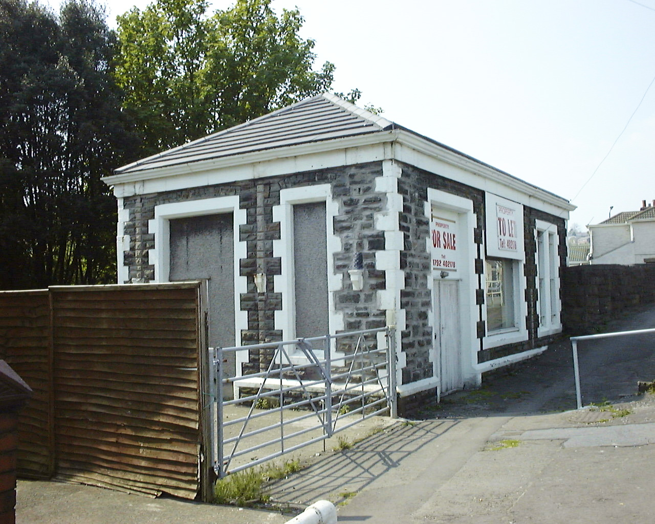
English: Former Morriston West Station (Clase Road) This building on Clase Road housed the ticket office for the Great Western Railway's Morriston West Station. It opened in May 1881 and closed to passengers in June 1956. The line closed completely in October 1965. It became a shop for a number of years after closure. The running lines ran under the road - today the station area is a car park. This view was taken in 1998 when the structure was relatively unmodified. Today, the structure still stands, although an extra storey and a side extension have been added. The grainy image quality was due to the use of an early digital camera (Fuji MX700). |
| Date | |
| Source | From geograph.org.uk |
| Author | vectorkraft |
| Permission (Reusing this file) |
Creative Commons Attribution Share-alike license 2.0 |
| Attribution (required by the license) | vectorkraft / Former Morriston West Station (Clase Road) / |
| Camera location | | View this and other nearby images on: OpenStreetMap |
|---|
_(geograph_2733089).jpg¶ms=051.664413_N_-003.921390_E_globe:Earth_type:camera_source:geograph-osgb36(SS67219793)_heading:270.00&language=en)
| Object location | | View this and other nearby images on: OpenStreetMap |
|---|
_(geograph_2733089).jpg¶ms=051.664410_N_-003.921680_E_globe:Earth_class:object_type:object_source:geograph-osgb36(SS67199793)_heading:270.00&language=en)
Licensing
[edit]_(geograph_2733089).jpg&action=edit§ion=2)

|
This image was taken from the Geograph project collection. See this photograph's page on the Geograph website for the photographer's contact details. The copyright on this image is owned by vectorkraft and is licensed for reuse under the Creative Commons Attribution-ShareAlike 2.0 license.
|
This file is licensed under the Creative Commons Attribution-Share Alike 2.0 Generic license.
Attribution: vectorkraft
- You are free:
- to share – to copy, distribute and transmit the work
- to remix – to adapt the work
- Under the following conditions:
- attribution – You must give appropriate credit, provide a link to the license, and indicate if changes were made. You may do so in any reasonable manner, but not in any way that suggests the licensor endorses you or your use.
- share alike – If you remix, transform, or build upon the material, you must distribute your contributions under the same or compatible license as the original.
File history
Click on a date/time to view the file as it appeared at that time.
| Date/Time | Thumbnail | Dimensions | User | Comment | |
|---|---|---|---|---|---|
| current | 18:50, 9 January 2021 | | 1,280 × 1,024 (448 KB) | Lamberhurst (talk | contribs) | Transferred from geograph.co.uk using [https://tools.wmflabs.org/geograph2commons/ geograph2commons] |
You cannot overwrite this file.
File usage on Commons
The following page uses this file:
File usage on other wikis
The following other wikis use this file:
- Usage on en.wikipedia.org
_(geograph_2733089).jpg&oldid=637236071)