File:Former Foundling Home of Malaga 01.jpg
Jump to navigation
Jump to search
Size of this preview: 800 × 600 pixels. Other resolutions: 320 × 240 pixels | 640 × 480 pixels | 1,024 × 768 pixels | 1,280 × 960 pixels | 2,560 × 1,920 pixels | 4,000 × 3,000 pixels.
Original file (4,000 × 3,000 pixels, file size: 2.17 MB, MIME type: image/jpeg)
Captions
Captions
Add a one-line explanation of what this file represents
Summary
[edit]| Description |
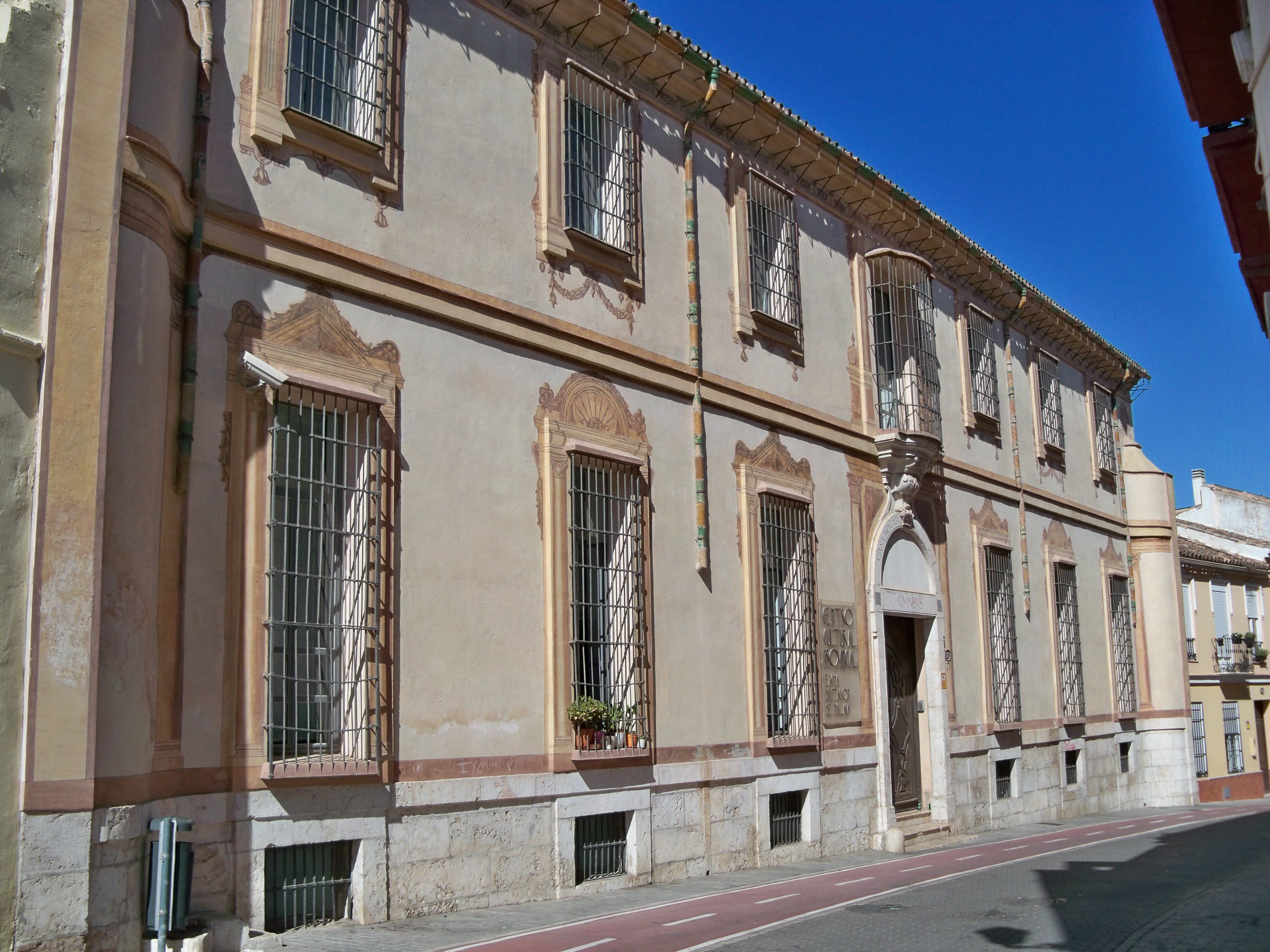
Español: Antigua Casa de Expósitos, también conocida como Casa Cuna de San José o Casa Hogar de San José (no confundir con la Gota de Leche, de titularidad municipal), en el número 17 de la calle Parras, Málaga, España, actual sede del Centro Cultural Provincial María Victoria Atencia y del Centro de la Generación del 27 de la Diputación de Málaga. La Casa Cuna de San José estaba destinada a la acogida de niños huérfanos o abandonados, a menudo dejados junto a su puerta de entrada. Tenía dos puertas, una daba a la calle Parras y la otra a la calle Ollerías. Los menores permanecían en este hogar de expósitos hasta que cumplían siete años. A partir de esa edad eran trasladados a la Casa de la Misericordia (hoy Centro Cívico), donde estaban hasta que cumplían 18 años aprendiendo un oficio. La Diputación asumía el mantenimiento de ambos centros. La Casa Cuna abandonó estas instalaciones en 1950 para trasladarse a un edificio erigido en la Huerta de Godino (junto al solar donde luego se hizo el Hospital Materno Infantil). [1] Se trata de un edificio barroco con aires neoclásicos, construido en el siglo XVIII y ampliado en el XIX. Su ejecución correspondió Ventura Rodríguez a partir de un proyecto del arquitecto granadino José Bada y bajo la dirección posiblemente de Martín de Aldehuela. Consta de semizótano, planta baja y primer piso, con un zócalo de sillería en su fachada y decoración pictórica exterior al fresco. |
| Date | |
| Source | Own work |
| Author | Daniel Capilla |
| Other versions |
|

| Object location | | View this and other nearby images on: OpenStreetMap |
|---|
| Camera location | | View this and other nearby images on: OpenStreetMap |
|---|
Licensing
[edit]
Daniel Capilla, the copyright holder of this work, hereby publishes it under the following license:
This file is licensed under the Creative Commons Attribution-Share Alike 4.0 International license.
Attribution: Daniel Capilla
- You are free:
- to share – to copy, distribute and transmit the work
- to remix – to adapt the work
- Under the following conditions:
- attribution – You must give appropriate credit, provide a link to the license, and indicate if changes were made. You may do so in any reasonable manner, but not in any way that suggests the licensor endorses you or your use.
- share alike – If you remix, transform, or build upon the material, you must distribute your contributions under the same or compatible license as the original.
File history
Click on a date/time to view the file as it appeared at that time.
| Date/Time | Thumbnail | Dimensions | User | Comment | |
|---|---|---|---|---|---|
| current | 17:32, 22 August 2022 | | 4,000 × 3,000 (2.17 MB) | Dcapillae (talk | contribs) | Uploaded own work with UploadWizard |
You cannot overwrite this file.
File usage on Commons
The following 2 pages use this file: