File:Ford Green & Smallthorne station site geograph-3523726-by-Ben-Brooksbank.jpg
Jump to navigation
Jump to search

Size of this preview: 800 × 437 pixels. Other resolutions: 320 × 175 pixels | 640 × 349 pixels | 1,024 × 559 pixels | 1,280 × 699 pixels | 2,391 × 1,305 pixels.
Original file (2,391 × 1,305 pixels, file size: 3.13 MB, MIME type: image/jpeg)
Captions
Captions
Add a one-line explanation of what this file represents
Summary
[edit]
| Description |
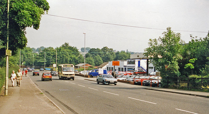
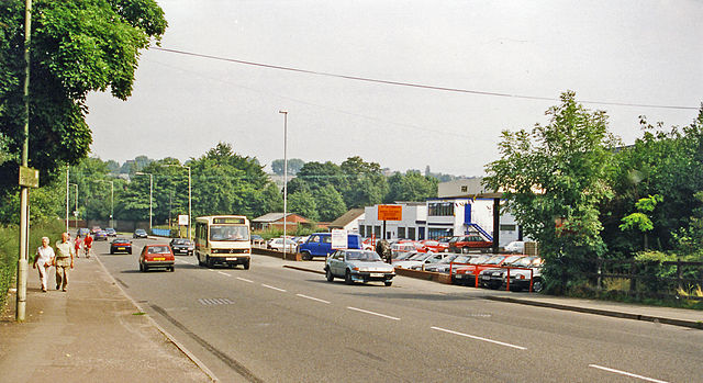
English: Site of Ford Green & Smallthorne station, 1999. View NE on the B5051 Burslem - Endon road. The station, which closed to passengers 11/7/27 (goods 6/1/64), had been on the right: ex-North Stafford Stoke-on-Trent - Biddulph - Congleton line: this (closed north of Biddulph 1/4/68) ran underneath the road and last bore a train in February 1989. The White Valley Nature Reserve on the Biddulph River is on the left. |
| Date | |
| Source | From geograph.org.uk |
| Author | Ben Brooksbank |
| Permission (Reusing this file) |
Creative Commons Attribution Share-alike license 2.0 |
| Attribution (required by the license) | Ben Brooksbank / Site of Ford Green & Smallthorne station, 1999 / |
| Camera location | | View this and other nearby images on: OpenStreetMap |
|---|
Licensing
[edit]

|
This image was taken from the Geograph project collection. See this photograph's page on the Geograph website for the photographer's contact details. The copyright on this image is owned by Ben Brooksbank and is licensed for reuse under the Creative Commons Attribution-ShareAlike 2.0 license.
|
This file is licensed under the Creative Commons Attribution-Share Alike 2.0 Generic license.
Attribution: Ben Brooksbank
- You are free:
- to share – to copy, distribute and transmit the work
- to remix – to adapt the work
- Under the following conditions:
- attribution – You must give appropriate credit, provide a link to the license, and indicate if changes were made. You may do so in any reasonable manner, but not in any way that suggests the licensor endorses you or your use.
- share alike – If you remix, transform, or build upon the material, you must distribute your contributions under the same or compatible license as the original.
File history
Click on a date/time to view the file as it appeared at that time.
| Date/Time | Thumbnail | Dimensions | User | Comment | |
|---|---|---|---|---|---|
| current | 09:31, 3 August 2013 | | 2,391 × 1,305 (3.13 MB) | Chevin (talk | contribs) | == {{int:filedesc}} == {{Information |Description={{en|1='''Site of Ford Green & Smallthorne station, 1999.'''<br/> View NE on the B5051 Burslem - Endon road. The station, which closed to passengers 11/7/27 (goods 6/1/64), had been on the right: ex-Nor... |
You cannot overwrite this file.
File usage on Commons
The following page uses this file:
File usage on other wikis
The following other wikis use this file:
- Usage on en.wikipedia.org