File:Forarc Region.png
Jump to navigation
Jump to search
No higher resolution available.
Forarc_Region.png (499 × 310 pixels, file size: 132 KB, MIME type: image/png)
Captions
Captions
Add a one-line explanation of what this file represents
Summary
[edit]
| Description |
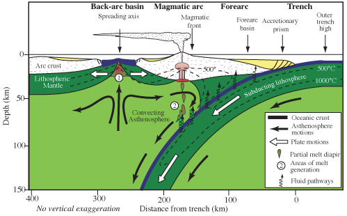
English: The basin in the forearc region is located on the subduction zone side of the volcanic arc |
| Date | |
| Source | Own work |
| Author | Stridersword |
Licensing
[edit]
I, the copyright holder of this work, hereby publish it under the following license:
This file is licensed under the Creative Commons Attribution-Share Alike 4.0 International license.
- You are free:
- to share – to copy, distribute and transmit the work
- to remix – to adapt the work
- Under the following conditions:
- attribution – You must give appropriate credit, provide a link to the license, and indicate if changes were made. You may do so in any reasonable manner, but not in any way that suggests the licensor endorses you or your use.
- share alike – If you remix, transform, or build upon the material, you must distribute your contributions under the same or compatible license as the original.
File history
Click on a date/time to view the file as it appeared at that time.
| Date/Time | Thumbnail | Dimensions | User | Comment | |
|---|---|---|---|---|---|
| current | 03:15, 28 September 2023 | | 499 × 310 (132 KB) | Stridersword (talk | contribs) | Uploaded while editing "Forearc" on en.wikipedia.org |
You cannot overwrite this file.
File usage on Commons
There are no pages that use this file.