File:Footpath to Huggetts Furnace Farm by Dave Spicer.jpg
Jump to navigation
Jump to search

Size of this preview: 800 × 600 pixels. Other resolutions: 320 × 240 pixels | 640 × 480 pixels | 1,024 × 768 pixels | 1,280 × 960 pixels | 1,600 × 1,200 pixels.
Original file (1,600 × 1,200 pixels, file size: 754 KB, MIME type: image/jpeg)
Captions
Captions
Add a one-line explanation of what this file represents
| Description |
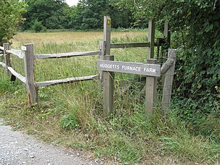
English: "Footpath to Huggetts Furnace Farm," by Dave Spicer, geograph.org. The photograph shows the footpath to the farm once owned by Ralph Huggett (or Ralph Hogge), who began his career as an English iron-master and gunstone-maker to the Rev. William Levett, a Sussex vicar. Huggetts Farm was the site of a blast furnace operated by Ralph Huggett, and is located on a stream between the villages of Buxted and Hadlow Down.[1] |
||||||||||||||||
| Date | |||||||||||||||||
| Source | geograph.org | ||||||||||||||||
| Author | Dave Spicer | ||||||||||||||||
| Permission (Reusing this file) |
== Summary ==
This file is licensed under the Creative Commons Attribution-Share Alike 2.0 Generic license. Attribution: Dave Spicer
|

File history
Click on a date/time to view the file as it appeared at that time.
| Date/Time | Thumbnail | Dimensions | User | Comment | |
|---|---|---|---|---|---|
| current | 15:52, 10 September 2017 | | 1,600 × 1,200 (754 KB) | Geograph Update Bot (talk | contribs) | Higher-resolution version from Geograph. |
| 21:37, 1 May 2011 |  | 640 × 480 (132 KB) | MarmadukePercy (talk | contribs) | {{Information |Description ={{en|1="Footpath to Huggetts Furnace Farm," by Dave Spicer, geograph.org. The photograph shows the footpath to the farm once owned by Ralph Huggett (or Ralph Hogge), who began his career as an English iron-master and gunston |
You cannot overwrite this file.
File usage on Commons
There are no pages that use this file.