File:Footpath through the maize towards Treen - geograph.org.uk - 230342.jpg
Jump to navigation
Jump to search

Size of this preview: 450 × 600 pixels. Other resolutions: 180 × 240 pixels | 480 × 640 pixels.
Original file (480 × 640 pixels, file size: 108 KB, MIME type: image/jpeg)
Captions
Captions
Add a one-line explanation of what this file represents
Summary
[edit]
| Description |
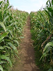
English: Footpath through the maize towards Treen. This footpath through the maize crop links the iron-age promontory castle at Treryn Dinas with the hamlet of Treen. In the usual Cornish way the hamlet is literally named after the nearby cliff castle. In 1478 it was written "Trethyn"... "Tre" meaning 'farm/settlement' and "din" meaning 'fort'. The d/th part has been lost over the years. Confusingly enough there is another hamlet called Treen on the north coast, near the iron age cliff castle on the Gurnard's Head peninsula. |
| Date | |
| Source | From geograph.org.uk |
| Author | Jim Champion |
| Attribution (required by the license) | Jim Champion / Footpath through the maize towards Treen / |
| Object location | | View this and other nearby images on: OpenStreetMap |
|---|
_heading:337.00&language=en)
Licensing
[edit]

|
This image was taken from the Geograph project collection. See this photograph's page on the Geograph website for the photographer's contact details. The copyright on this image is owned by Jim Champion and is licensed for reuse under the Creative Commons Attribution-ShareAlike 2.0 license.
|
This file is licensed under the Creative Commons Attribution-Share Alike 2.0 Generic license.
Attribution: Jim Champion
- You are free:
- to share – to copy, distribute and transmit the work
- to remix – to adapt the work
- Under the following conditions:
- attribution – You must give appropriate credit, provide a link to the license, and indicate if changes were made. You may do so in any reasonable manner, but not in any way that suggests the licensor endorses you or your use.
- share alike – If you remix, transform, or build upon the material, you must distribute your contributions under the same or compatible license as the original.
File history
Click on a date/time to view the file as it appeared at that time.
| Date/Time | Thumbnail | Dimensions | User | Comment | |
|---|---|---|---|---|---|
| current | 00:14, 1 February 2010 | | 480 × 640 (108 KB) | GeographBot (talk | contribs) | == {{int:filedesc}} == {{Information |description={{en|1=Footpath through the maize towards Treen. This footpath through the maize crop links the iron-age promontory castle at Treryn Dinas with the hamlet of Treen. In the usual Cornish way the hamlet is l |
You cannot overwrite this file.
File usage on Commons
There are no pages that use this file.