File:Footpath alongside the site of the former Merton Park station (geograph 5289810).jpg

Original file (4,000 × 3,000 pixels, file size: 4.58 MB, MIME type: image/jpeg)
Captions
Captions
Summary
[edit].jpg&action=edit§ion=1)
| Description |
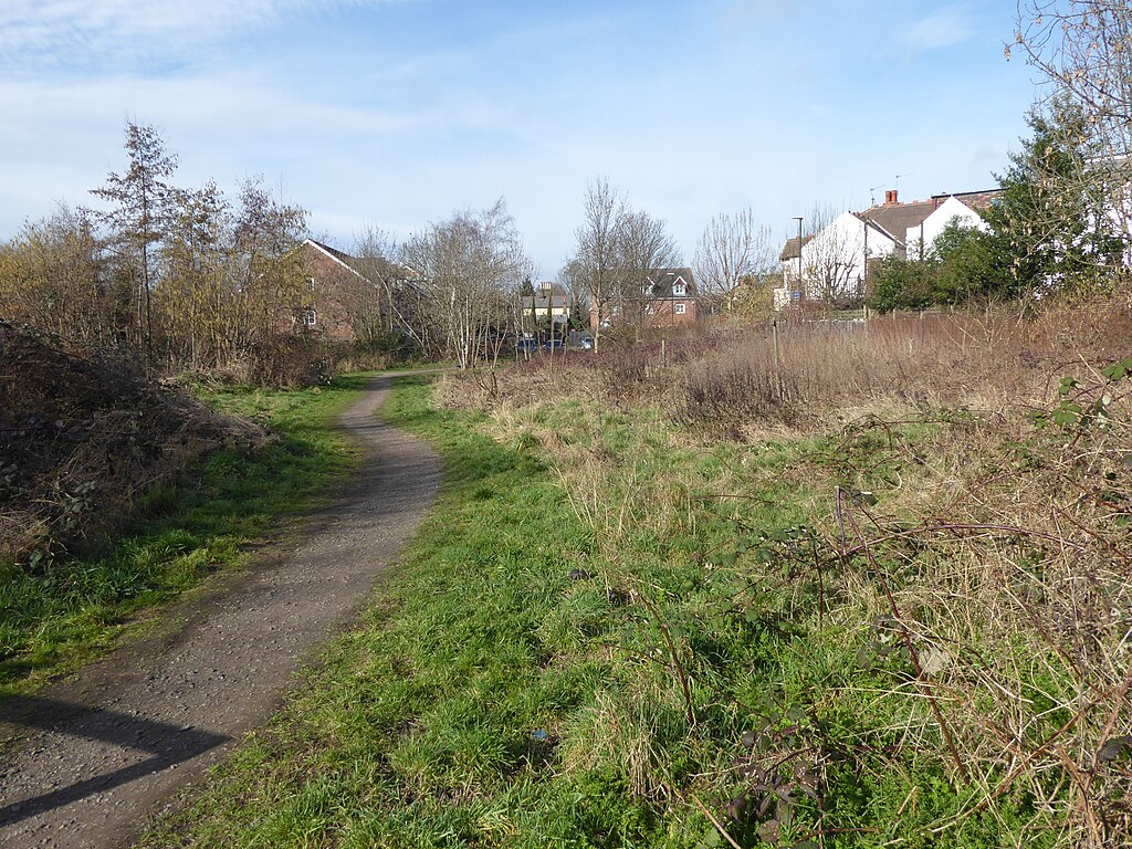
English: Footpath alongside the site of the former Merton Park station The Wimbledon to West Croydon Line was opened in 1855. In 1868, the Tooting, Wimbledon & Sutton line was opened, and a branch from Tooting via Merton Abbey to the Wimbledon to West Croydon line at Merton Park was also opened. Initially a station was only provided on the Tooting line called Lower Merton which opened on 1st October 1868. This had a stationmaster's house incorporating a booking office on the down platform. This building still exists, but is now a private house called Station House. It is the yellow house in the far distance in the centre of the photograph. A new platform was opened on the Mitcham line on 1st November 1870 and the station which then served both lines was called Merton Park from 1st September 1887. The last passenger train on the Tooting to Merton Park line ran on 2nd March 1929, and after that only steam freight trains and the occasional excursion used the line. The junction at the Tooting end was severed in 1934 so that the line was worked as a long siding from Merton Park. All traffic finally ceased in May 1975 and the tracks between Merton Park and Tooting were removed soon afterwards. Passengers for Merton Park station on the Wimbledon to West Croydon line then had to cross two disused platforms until that line closed in 1997, to be replaced from May 2000 by Tramlink. Part of the old trackbed of the Tooting branch has been preserved. A small section of the down Tooting branch platform survives but whereas ten years ago this could easily be seen it is now almost unrecognisable through brambles. The former station was ahead here and the line to Tooting swung round to the right of the photograph. The Mitcham branch platform has been removed and no trace remains - the new Merton Park Tramlink stop is further towards Wimbledon, just before Morden Road. |
| Date | |
| Source | From geograph.org.uk |
| Author | Marathon |
| Permission (Reusing this file) |
Creative Commons Attribution Share-alike license 2.0 |
| Attribution (required by the license) | Marathon / Footpath alongside the site of the former Merton Park station / |
| Camera location | | View this and other nearby images on: OpenStreetMap |
|---|
.jpg¶ms=051.412579_N_-000.199965_E_globe:Earth_type:camera_source:geograph-osgb36(TQ25286971)_heading:315.00&language=en)
| Object location | | View this and other nearby images on: OpenStreetMap |
|---|
.jpg¶ms=051.413310_N_-000.200940_E_globe:Earth_class:object_type:object_source:geograph-osgb36(TQ25216979)_heading:315.00&language=en)
Licensing
[edit].jpg&action=edit§ion=2)

|
This image was taken from the Geograph project collection. See this photograph's page on the Geograph website for the photographer's contact details. The copyright on this image is owned by Marathon and is licensed for reuse under the Creative Commons Attribution-ShareAlike 2.0 license.
|
- You are free:
- to share – to copy, distribute and transmit the work
- to remix – to adapt the work
- Under the following conditions:
- attribution – You must give appropriate credit, provide a link to the license, and indicate if changes were made. You may do so in any reasonable manner, but not in any way that suggests the licensor endorses you or your use.
- share alike – If you remix, transform, or build upon the material, you must distribute your contributions under the same or compatible license as the original.
File history
Click on a date/time to view the file as it appeared at that time.
| Date/Time | Thumbnail | Dimensions | User | Comment | |
|---|---|---|---|---|---|
| current | 21:27, 8 November 2020 | | 4,000 × 3,000 (4.58 MB) | Lamberhurst (talk | contribs) | Transferred from geograph.co.uk using [https://tools.wmflabs.org/geograph2commons/ geograph2commons] |
You cannot overwrite this file.
File usage on Commons
The following page uses this file:
.jpg&oldid=860894973)