File:Flugroute von Mathias Rust.svg
Jump to navigation
Jump to search

Size of this PNG preview of this SVG file: 800 × 580 pixels. Other resolutions: 320 × 232 pixels | 640 × 464 pixels | 1,024 × 743 pixels | 1,280 × 928 pixels | 2,560 × 1,857 pixels | 1,125 × 816 pixels.
Original file (SVG file, nominally 1,125 × 816 pixels, file size: 1.39 MB)
Captions
Captions
Add a one-line explanation of what this file represents
| Description |
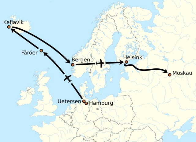
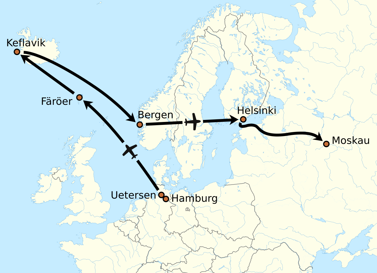
Deutsch: ungefähre Flugroute von Mathias Rust im Mai 1987 |
| Date | (UTC) |
| Source | |
| Author |
|
| Other versions |
[]
|


I, the copyright holder of this work, hereby publish it under the following license:
This file is licensed under the Creative Commons Attribution-Share Alike 3.0 Unported license.
- You are free:
- to share – to copy, distribute and transmit the work
- to remix – to adapt the work
- Under the following conditions:
- attribution – You must give appropriate credit, provide a link to the license, and indicate if changes were made. You may do so in any reasonable manner, but not in any way that suggests the licensor endorses you or your use.
- share alike – If you remix, transform, or build upon the material, you must distribute your contributions under the same or compatible license as the original.
Original upload log
[edit]
This image is a derivative work of the following images:
- File:Europe_laea_location_map.svg licensed with Cc-by-sa-3.0
- 2010-03-10T19:40:39Z Alexrk2 1401x1198 (2313185 Bytes) +San Marino, enh. coastline & countries
- 2010-03-10T18:44:00Z Alexrk2 1401x1198 (1521812 Bytes) == Summary == {{Information |Description= {{de|Positionskarte [[:de:Europa|Europa]]; Politisch mit Staatsgrenzen, Inlandgewässer; Flächentreue Azimutalprojektion}} {{en|Location map [[:en:Europe|Europe]]; Political with sta

|
This map has been made or improved in the German Kartenwerkstatt (Map Lab). You can propose maps to improve as well.
|
File history
Click on a date/time to view the file as it appeared at that time.
| Date/Time | Thumbnail | Dimensions | User | Comment | |
|---|---|---|---|---|---|
| current | 20:01, 25 July 2011 | | 1,125 × 816 (1.39 MB) | NordNordWest (talk | contribs) | c |
| 18:22, 25 July 2011 |  | 1,125 × 816 (1.39 MB) | NordNordWest (talk | contribs) | c | |
| 18:15, 25 July 2011 |  | 1,125 × 816 (1.39 MB) | NordNordWest (talk | contribs) | {{Information |Description={{de|ungefähre Flugroute von Mathias Rust im Mai 1987}} |Source=*File:Europe_laea_location_map.svg |Date=2011-07-25 18:13 (UTC) |Author=*File:Europe_laea_location_map.svg: Alexrk2 *derivative work: |
You cannot overwrite this file.
File usage on Commons
The following 5 pages use this file:
File usage on other wikis
The following other wikis use this file:
- Usage on ar.wikipedia.org
- Usage on be.wikipedia.org
- Usage on cs.wikipedia.org
- Usage on cv.wikipedia.org
- Usage on da.wikipedia.org
- Usage on de.wikipedia.org
- Usage on eo.wikipedia.org
- Usage on es.wikipedia.org
- Usage on et.wikipedia.org
- Usage on eu.wikipedia.org
- Usage on fr.wikipedia.org
- Usage on gl.wikipedia.org
- Usage on hr.wikipedia.org
- Usage on it.wikipedia.org
- Usage on ja.wikipedia.org
- Usage on lmo.wikipedia.org
- Usage on nl.wikipedia.org
- Usage on nn.wikipedia.org
- Usage on no.wikipedia.org
- Usage on pl.wikipedia.org
- Usage on ro.wikipedia.org
- Usage on sh.wikipedia.org
- Usage on sv.wikipedia.org
- Usage on uk.wikipedia.org
- Usage on vi.wikipedia.org
- Usage on zh.wikipedia.org