File:Floridae Americae provinciae recens & exactissima descriptio auctorè Iacobo le Moyne cui cognomen de Morgues, qui Laudōnierum, altera Gallorum in eam prouinciam nauigatione comitat est, atque LOC 2003623393.jpg
Jump to navigation
Jump to search

Size of this preview: 756 × 599 pixels. Other resolutions: 303 × 240 pixels | 606 × 480 pixels | 969 × 768 pixels | 1,280 × 1,015 pixels | 2,560 × 2,030 pixels | 5,644 × 4,475 pixels.
Original file (5,644 × 4,475 pixels, file size: 3.83 MB, MIME type: image/jpeg)
Captions
Captions
Add a one-line explanation of what this file represents
Summary
[edit]| Description |
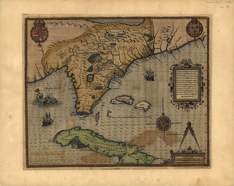
English: Relief shown pictorially. Shows Florida region, northeastern coastline, Port Royal, Fort Caroline, Cuba, rivers, cities, and other geographical entities. Mounted on cloth backing. Published in Le Moyne's Brevis narratio eorum quae in Florida Americae provincia Gallis acciderunt ... 1591, pt. 2 of Théodore de Bry's Great voyages. Accompanied by a reduced reproduction, with missing medallion and part of title and scale bar cut-off. (1 map ; 18 x 20 cm.). Copy annotated in pencil. Available also through the Library of Congress Web site as a raster image. |
||
| Title | Floridae Americae provinciae recens & exactissima descriptio auctorè Iacobo le Moyne cui cognomen de Morgues, qui Laudōnierum, altera Gallorum in eam prouinciam nauigatione comitat est, atque adhibitis aliquot militibus ob pericula, regionis illius interiora & maritima diligentissimè lustrauit, & exactissimè dimensus est, obseruata etiam singulorum fluminum inter se distantia, ut ipsemet redux Carolo .IX. Galliarum regi, demonstrauit. | ||
| Shelf ID | G3930 1591 .L4 | ||
| Date | |||
| Source | https://www.loc.gov/item/2003623393/ | ||
| Author | Le Moyne De Morgues, Jacques | ||
| Permission (Reusing this file) |
|
||
| Other versions |
|
||
| Location | United States · Florida · Cuba | ||
| Part of | American Memory · General Maps · Catalog · Geography And Map Division | ||
| Subject | United States · Maps · Early Works To 1800 · Florida · Cuba |


Licensing
[edit]
|
This is a faithful photographic reproduction of a two-dimensional, public domain work of art. The work of art itself is in the public domain for the following reason:
The official position taken by the Wikimedia Foundation is that "faithful reproductions of two-dimensional public domain works of art are public domain".
This photographic reproduction is therefore also considered to be in the public domain in the United States. In other jurisdictions, re-use of this content may be restricted; see Reuse of PD-Art photographs for details. | ||||
File history
Click on a date/time to view the file as it appeared at that time.
| Date/Time | Thumbnail | Dimensions | User | Comment | |
|---|---|---|---|---|---|
| current | 01:57, 15 May 2018 | | 5,644 × 4,475 (3.83 MB) | Fæ (talk | contribs) | LOC Maps https://www.loc.gov/item/2003623393/ #220 |
You cannot overwrite this file.
File usage on Commons
The following page uses this file: