File:Florence Falls Bridge on The Gunsight Pass Trail as the Florence Falls Creek rapidly drains downhill into the calm Saint Mary River and Valley beginning its unique journey north to the Artic Ocean, Glacier National Park - panoramio.jpg
Jump to navigation
Jump to search

Size of this preview: 800 × 600 pixels. Other resolutions: 320 × 240 pixels | 640 × 480 pixels | 1,024 × 768 pixels | 1,280 × 960 pixels | 1,600 × 1,200 pixels.
Original file (1,600 × 1,200 pixels, file size: 648 KB, MIME type: image/jpeg)
Captions
Captions
Add a one-line explanation of what this file represents
Summary
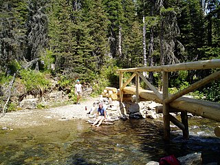
[edit]| Description | Florence Falls Bridge on The Gunsight Pass Trail as the Florence Falls Creek rapidly drains downhill into the calm Saint Mary River and Valley beginning its unique journey north to the Artic Ocean, Glacier National Park, MT July 23rd, 2007 | ||
| Date | Taken on 23 July 2007 | ||
| Source | https://web.archive.org/web/20161014025730/http://www.panoramio.com/photo/29902531 | ||
| Author | Gary Miotla | ||
| Permission (Reusing this file) |
This file is licensed under the Creative Commons Attribution 3.0 Unported license. Attribution: Gary Miotla
|
||
| Tags (from Panoramio photo page) | Glacier County, Florence Falls Bridge, Glacier National Park, Mapped Photos Not Selected For Google Earth, Montana, The Saint Mary River Valley |
| Camera location | | View this and other nearby images on: OpenStreetMap |
|---|

File history
Click on a date/time to view the file as it appeared at that time.
| Date/Time | Thumbnail | Dimensions | User | Comment | |
|---|---|---|---|---|---|
| current | 16:11, 9 December 2016 | | 1,600 × 1,200 (648 KB) | Panoramio upload bot (talk | contribs) | == {{int:filedesc}} == {{Information |description=Florence Falls Bridge on The Gunsight Pass Trail as the Florence Falls Creek rapidly drains downhill into the calm Saint Mary River and Valley beginning its unique journey north to the Artic Ocean, Glac... |
You cannot overwrite this file.
File usage on Commons
There are no pages that use this file.